

A new commercial pilot in Australia often reaches the same point. The aircraft is sorted, the mapping app is installed, and a client wants a contour plan, progress map, stockpile volume, or site model by the end of the week. That's when critical questions arise. Which sensor is worth buying. What accuracy is realistic. When a RePL is enough, and when it isn't. What has to happen between the first flight line and the final GeoTIFF, LAS file, or report.
Drone mapping and surveying can solve real operational problems fast. A construction manager can see site progress without waiting on a full ground crew. A rural operator can assess broad areas with less time spent driving paddocks. An asset owner can inspect difficult terrain without putting staff in unsafe positions. The broader commercial environment is also changing quickly, as seen across the Australian drone ecosystem discussed in this overview of drone work in Australia.
What matters is doing it properly. Good-looking maps aren't the same as compliant deliverables. Crisp imagery isn't the same as survey-grade output. A legal flight isn't automatically a legal survey.
Table of Contents
- From Blueprints to Pixels: An Introduction to Drone Mapping
- Photogrammetry vs LiDAR Choosing Your Mapping Technology
- The Five Phases of a Drone Surveying Project
- From Metres to Centimetres Achieving Survey-Grade Accuracy
- Navigating CASA Rules and Licensing in Australia
- Drone Mapping in Action: Australian Industry Use Cases
- Frequently Asked Questions About Drone Surveying
From Blueprints to Pixels: An Introduction to Drone Mapping
A site manager rings at 4 pm and wants earthworks quantities before the morning meeting. A grazier needs a current surface model after heavy rain cut new drainage lines across a paddock. In both jobs, the value is not the aircraft. It is reliable spatial data delivered in a format the client can use straight away.
Drone mapping and surveying converts aerial capture into measured outputs such as orthomosaics, elevation models, point clouds, and 3D surfaces. For Australian operators, that work sits across aviation, geospatial processing, and compliance. That distinction matters commercially. Holding a RePL may let you fly for hire under the right operating structure, but it does not automatically qualify you to sign off survey work that must meet cadastral or regulated surveying standards.
That gap catches new operators out. Clients often ask for a "drone survey" when they really want one of three things: a visual site record, measurable topographic data, or a product that must be issued under a licensed surveyor's authority. If you do not define that scope at the start, you can price the job wrong, promise the wrong accuracy, and deliver files the client cannot rely on.
The first business gains usually show up in practical places:
- Faster site coverage: One flight can capture broad areas with less field time than conventional point-by-point pickup on open ground.
- Lower exposure to hazards: Batter edges, stockpiles, drainage channels, and soft ground can be measured without sending staff through every section.
- Better reporting: Clients get surfaces, contours, volumes, and dated visual records instead of scattered photos and handwritten notes.
- More flexible service options: Small operators can start with image-based mapping, add control and QA processes, then decide whether higher-end sensors or subcontract survey oversight make financial sense.
For many SMEs, that staged approach is the smart one. A well-run photogrammetry workflow can cover a lot of construction, quarry, and agricultural work without the capital cost of specialist payloads. The trade-off is that the aircraft is usually the cheapest part of the service. Accuracy checks, control, processing time, insurance, CASA compliance, software, and reporting discipline are what turn a flight into a product you can invoice with confidence.
Operators building a mapping business in Australia also need to understand where they fit in the wider Australian commercial drone industry and training ecosystem. The pilots who last in this field are not the ones with the flashiest drone. They are the ones who scope jobs properly, know when to involve a licensed surveyor, and deliver data that stands up under scrutiny from engineers, project managers, and asset owners.
Practical rule: If the client needs defensible measurements, the workflow and sign-off pathway matter more than the drone model.
Photogrammetry vs LiDAR Choosing Your Mapping Technology
Most Australian operators start with one decision that affects everything else. Should the business rely on photogrammetry, or invest in LiDAR.
How photogrammetry works in practice
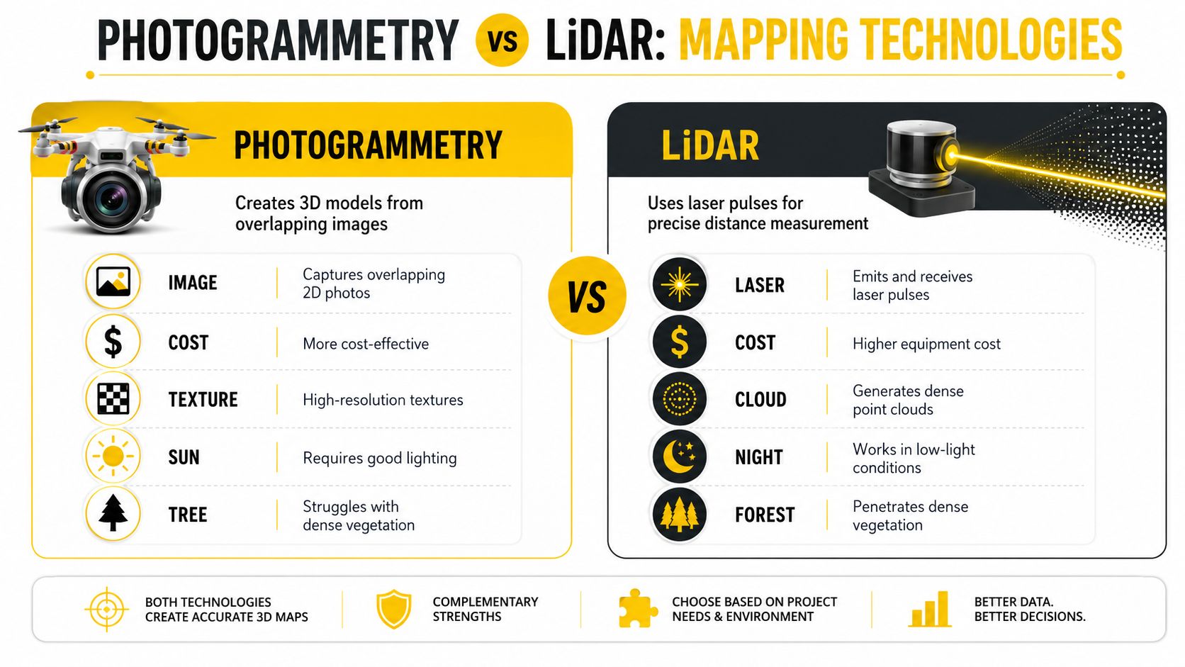
Photogrammetry builds a 3D model from many overlapping images. The software matches common features across photographs, reconstructs camera positions, and creates surfaces and imagery products from that geometry.
For many SMEs, photogrammetry is the practical entry point. It delivers strong outputs for construction progress, stockpiles, open ground topography, façades, and visual site records. It also produces textured models that clients can understand immediately.
What catches new operators out is that good photogrammetry demands discipline:
- Consistent overlap: Weak overlap creates holes, warping, and poor edges.
- Stable lighting: Heavy shadow, glare, or low texture reduce feature matching.
- Clear control strategy: If the project needs measured accuracy, image quality alone won't save it.
- Tidy field notes: Processing problems often trace back to poor naming, poor control records, or rushed setup.
Where LiDAR earns its keep
LiDAR measures distance directly using laser pulses. It's less dependent on visible image texture and is often the better choice where vegetation, irregular terrain, or low-light conditions make photogrammetry harder to trust.
For operators working in bushland, drainage corridors, or sites with heavy canopy, LiDAR can justify itself. The trade-off is cost and complexity. The economic reality for regional Australian SMEs is clear in Wingtra's surveying overview, which notes that high-end LiDAR can exceed $50,000 AUD, while centimetre-level photogrammetry remains achievable with a disciplined workflow using GCPs.
Dense vegetation is where the sales pitch ends and the project reality starts. If the ground can't be seen reliably in the imagery, photogrammetry may still produce a model, but not the one the client thinks they're buying.
Comparison of Photogrammetry and LiDAR for Drone Surveying
| Factor | Photogrammetry | LiDAR |
|---|---|---|
| Core method | Builds 3D outputs from overlapping photos | Measures distance with laser pulses |
| Best fit | Open ground, stockpiles, construction progress, textured models | Vegetated terrain, complex ground surfaces, low-texture environments |
| Output style | Strong visual detail and realistic textures | Dense point clouds with strong geometric capture |
| Lighting dependence | More dependent on suitable light and image quality | Less dependent on lighting for measurement |
| Vegetation performance | Struggles when canopy hides the ground | Better suited to dense vegetation |
| Business entry point | Lower barrier for many SMEs | Higher capital burden and workflow complexity |
What makes sense for an Australian SME
For many regional operators, the wrong move is buying gear for edge cases. A business that mainly maps quarries, rural compounds, building sites, and open terrain usually gets more value from an effective photogrammetry workflow than from chasing a LiDAR badge.
A smarter progression often looks like this:
- Start with photogrammetry if the work is mainly visible-surface mapping.
- Invest in control gear and process discipline before upgrading payloads.
- Move to LiDAR when vegetation penetration or specialised terrain work becomes regular revenue, not occasional curiosity.
For beginners who are still deciding whether this field fits their goals, ACE READY is an entry level drone training course covering drone fundamentals, aviation safety, CASA regulations, flight operations, and preparation for advanced Remote Pilot Licence training in Australia. That kind of foundation matters because technology decisions only work when the operator understands the mission profile behind them.
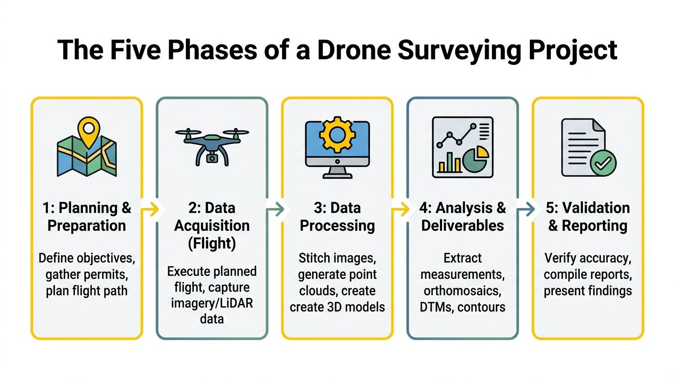
The Five Phases of a Drone Surveying Project
A professional mapping job has a repeatable structure. The aircraft and software matter, but the workflow decides whether the output is usable.
Phase 1 planning and safety assessment
Most failures start before take-off. The operator needs the site boundary, the deliverable type, the required coordinate system, access constraints, airspace constraints, and client tolerance for turnaround.
For Australian infrastructure work, flight specifications often require a Ground Sample Distance of 10cm or finer, with 75 to 80% frontal overlap and 65 to 70% side overlap. In dense vegetation, overlap often needs to go above 80% to maintain model integrity, as set out in the WA drone survey image specification.
Planning usually includes:
- Airspace review: Controlled airspace, nearby aerodromes, restricted areas, and operational approvals.
- Site risk review: Powerlines, plant movement, public access, dust, slope, and launch options.
- Flight design: GSD target, overlap, speed, altitude, terrain following, and battery sequencing.
- Output definition: Orthomosaic, contour base, stockpile report, surface model, or point cloud.
For early scoping, a practical tool is a drone quote calculator, because pricing a mapping job properly depends on area, terrain complexity, deliverables, and compliance overhead, not just flight time.
Phase 2 field capture
Fieldwork is where shortcuts become expensive. Targets need to be visible, control needs to be measured properly, and the aircraft setup must match the mission plan.
Common field tasks include:
- Ground control placement: Targets need good spread across the site, including edges where practical.
- Checkpoint setup: Independent checks help verify the final product instead of trusting software blindly.
- Aircraft checks: Camera settings, shutter behaviour, GNSS status, storage, batteries, and return settings.
- On-site verification: Review image sharpness, missing strips, low overlap areas, and telemetry issues before leaving.
The job isn't finished when the flight lands. It's finished when the operator confirms the data is complete.
A second flight on the same day is cheap. A return trip after the site has changed is not.
Phase 3 processing and model generation
Processing starts with file discipline. Imagery, GNSS logs, control coordinates, flight notes, and site metadata need to be organised before software does any useful work.
The operator typically generates some mix of:
- Orthomosaic imagery
- Digital Surface Models
- Point clouds
- 3D meshes
- Contours or volume surfaces
What works is matching settings to the deliverable. High visual detail doesn't automatically improve survey reliability. Over-processing noisy inputs can create polished rubbish. Under-processing can leave gaps and rough geometry that should have been fixed upstream.
Phase 4 quality assurance
Professionals distinguish themselves from hobby operators. A clean model must still be checked against independent evidence.
Quality assurance often includes:
- Checkpoint comparison against surveyed points excluded from model adjustment.
- Surface review for doming, edge distortion, seam issues, and voids.
- Metadata review to confirm coordinate reference, vertical reference, and processing assumptions.
- Deliverable validation against the client brief and tolerance requirements.
One of the strongest habits a new operator can build is refusing to trust the first export.
Phase 5 delivery and reporting
Clients don't always need the same thing. Engineers may want structured data in GIS or CAD-friendly formats. Site managers may want a marked-up orthomosaic and a short progress note. Asset teams may need point clouds and an accompanying methodology summary.
The final package often includes:
- Mapped outputs in agreed formats such as GeoTIFF or LAS
- A short methods summary
- Coordinate and control notes
- Accuracy or validation notes where relevant
- Clear file naming and revision control
Operators who want a broader operational skill set can also look at ACE PLATINUM, which is described as a complete enterprise drone training package including RePL, AROC, Aviation English, Express ReOC, Certificate III in Aviation, advanced operations training, and preparation to operate and manage a commercial drone business.
From Metres to Centimetres Achieving Survey-Grade Accuracy
Accuracy is the first topic clients ask about and the one new operators misunderstand most often.
What accuracy actually means
Three ideas need to stay separate.
- GSD is the ground size represented by each image pixel.
- Absolute accuracy is how well the model fits real-world coordinates.
- Relative accuracy is how internally consistent the model is.
A model can look sharp and still be wrong in absolute position. That happens often when operators rely on onboard GPS only.
In Australian surveying workflows, survey-grade output requires RTK or PPK GNSS correction combined with 5 to 10 survey-grade GCPs. When that workflow is done properly, drone photogrammetry can achieve 1.5 to 2cm horizontal and 2.5 to 4cm vertical absolute accuracy, compared with 1 to 3 metre accuracy from standard GPS alone, as described in this drone mapping accuracy guide.
What works and what fails
What works is boring. Good control. Good GNSS correction. Good checkpoints. Good camera behaviour. Good overlap. Good processing hygiene.
What fails is predictable too:
- Relying on standard GPS for engineering work
- Skipping checkpoints because the preview looks fine
- Using poor control distribution
- Flying inconsistent height over uneven terrain
- Expecting software to fix weak field capture
For operators building toward this standard, specialised pathways such as advanced drone training options can help bridge the gap between basic flight competence and defensible technical deliverables.
Field note: Survey-grade accuracy isn't a drone feature. It's a workflow outcome.
Navigating CASA Rules and Licensing in Australia
A legal commercial mapping operation sits inside two different compliance worlds. One is aviation regulation. The other is surveying authority. New operators often understand the first and miss the second.
When a RePL is mandatory
For Australian commercial mapping and surveying, a Remote Pilot Licence (RePL) becomes mandatory when the operation sits outside the Excluded Category, including flights with drones over 2kg or operations within 5.5km of a controlled aerodrome in the situations described by this summary of Australian drone laws. To qualify, candidates must pass a CASA-approved theory exam with at least 85% and complete practical competency assessment through approved training.
Beyond pilot licensing, equipment administration matters too. Drones over 250 grams must be registered with CASA, and those over 500g require an annual $40 registration fee, with penalties for non-compliance outlined in this CASA registration guide.
For mapping work near aerodromes or in controlled airspace, an Aeronautical Radio Operator Certificate may also be required. The AROC theory pass mark is 80%, and operators need an ARN before applying for aviation interactions with CASA, as outlined in this guide to becoming a drone pilot in Australia.
The RePL and surveyor licence gap
This is the point many operators only discover after quoting the wrong job. A RePL allows a person to legally fly the drone. It does not automatically authorise that person to produce every kind of survey output for legal or certified use.
State-based surveying laws still matter. If the work concerns legal boundaries, cadastral outcomes, or certified engineering products, a licensed surveyor may need to control or sign off the work. That distinction is central to the regulatory gap described in this discussion of the surveyor licence issue for Australian drone operators.
That gap creates real business risk:
- A compliant flight can still produce a non-compliant deliverable
- Clients often use “mapping” and “surveying” interchangeably when they shouldn't
- Operators may quote work they can capture, but not legally certify
The safest approach is simple. Clarify the end use before accepting the project. If the deliverable supports legal boundaries or certified engineering decisions, involve a licensed surveyor early.
Training pathways that fit mapping work
Commercial mapping pilots need more than flight confidence. They need airspace knowledge, operational judgement, and enough technical discipline to know when a job crosses into surveying practice.
A practical pathway often includes:
- Remote Pilot Licence RePL for lawful commercial operations
- Aeronautical Radio Operator Certificate AROC where controlled airspace communication is relevant
- Certificate III in Aviation for broader operational grounding
- ReOC Consulting for organisations building compliant operating structures
- Enterprise Drone Training or Corporate Drone Training where teams need role-specific procedures
For operators building a business structure around compliant commercial work, this guide to the ReOC in Australia is a useful reference point.
Drone Mapping in Action: Australian Industry Use Cases
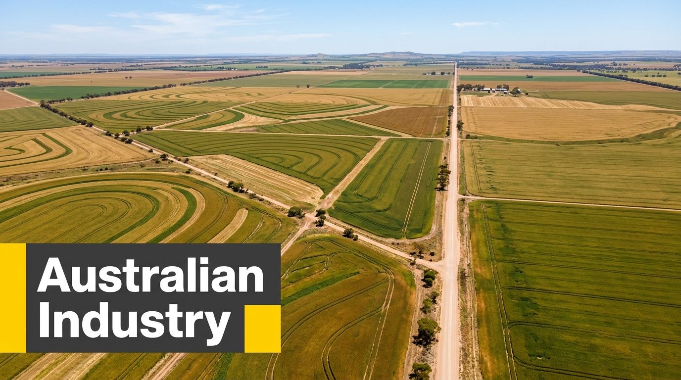
A builder wants weekly progress quantities by Friday. A mine wants updated stockpile volumes without sending staff onto active ground. A grower wants a map that leads to a decision before the next irrigation cycle. Drone mapping earns its keep when the output is tied to that operational need, and when the pilot understands what can be captured, what can be measured reliably, and what still needs a licensed surveyor in the loop.
Construction and civil sites
Construction is where many new operators start, because the value case is easy to explain. Site managers want current conditions, regular records, and simple comparisons against design intent or last month's progress. Orthomosaics, surface models, and stockpile reports all fit that brief.
Typical deliverables include:
- Orthomosaic progress maps
- Stockpile and bulk earthwork volume reports
- Surface models for planning reviews
- Visual records for dispute reduction
The business reality for SMEs is straightforward. Photogrammetry usually covers a large share of construction work at a lower equipment cost than LiDAR, but only if capture discipline is good. Poor overlap, weak ground control, or rushed processing can turn a cheap job into a callback. On civil sites, repeatability matters as much as headline accuracy because clients often compare one survey against the last.
Mining and heavy industry
Mining and industrial clients usually care less about presentation and more about whether the data can be used safely and repeatedly. If access is difficult, the drone has a clear advantage. If dust, vibration, heat haze, or exclusion zones are not managed properly, the advantage disappears quickly.
Drone work is useful for:
- Pit and stockpile monitoring
- Tailings dam observation
- Blast planning support
- Remote inspection of difficult ground
These jobs punish casual planning. Site inductions, radio procedures, spotters, and clear exclusion management are part of the job, not admin around it. For new operators, this is also where the gap between being able to fly and being trusted on an industrial site becomes obvious.
Agriculture and regional operations
Agricultural mapping covers a wide spread of work, from simple property records through to crop health layers and drainage analysis. The best operators in this sector do not just hand over pretty imagery. They match the sensor, flight timing, and processing output to a farm decision that has to be made soon.
Operators in this space often produce:
- Paddock orthomosaics
- Drainage and surface observation maps
- Multispectral crop health layers
- Property condition records
For many regional businesses, cost-benefit matters more than having the newest platform. A standard RGB workflow may be enough for erosion checks, fence line planning, or surface water assessment. Multispectral and spraying systems make sense when the client has a clear agronomic use for them and the scale of work supports the investment. Readers looking at that side of the market can see a practical example in this look at the XAG P150 Max for Australian agriculture.
The strongest agricultural mapping jobs are the ones where the grower can use the output the same week.
Frequently Asked Questions About Drone Surveying
FAQ Section
| Question | Answer |
|---|---|
| Can any drone create survey-grade outputs | No. The aircraft is only one part of the workflow. Survey-grade work depends on control, correction, planning, and validation. A capable drone without the right field and processing method won't produce defensible survey results. |
| What software should a new operator use | The right software depends on the deliverable. Photogrammetry suites suit orthomosaics, surfaces, and 3D models. Point cloud workflows matter more if the job involves LiDAR. A new operator should choose software that matches client outputs, not whichever interface looks easiest. |
| Is RTK enough on its own | Not for every job. RTK improves camera positioning, but verification still matters. If the deliverable supports engineering or compliance decisions, independent checkpoints and a clear QA process remain important. |
| When should a business buy LiDAR instead of using photogrammetry | LiDAR makes more sense when dense vegetation, complex terrain, or low-texture environments are regular project conditions. If most work is in open ground or construction environments, a disciplined photogrammetry workflow is often the more sensible business choice. |
| Does a RePL let an operator offer legal land surveys | No. A RePL authorises drone operation under the relevant aviation rules. It doesn't replace state-based surveying requirements for cadastral or legally certified survey work. |
| What training is most relevant for a pilot moving into mapping work | RePL training is the starting point for commercial flight. AROC may be relevant near controlled airspace. Broader aviation study, operational procedure training, and business compliance support become more useful as the work moves from simple capture into repeatable commercial operations. |
Ace Aviation Aerospace Academy provides Australian drone and aviation education for operators who need compliant, practical training. Relevant options for mapping-focused pilots include the Remote Pilot Licence, Aeronautical Radio Operator Certificate, Certificate III in Aviation, ReOC Consulting, Enterprise Drone Training, and Corporate Drone Training. More information is available through Ace Aviation Aerospace Academy.
