

Small Australian sites under 5 hectares typically cost A$500–A$1,500 per survey, medium sites of 5–50 hectares run A$1,500–A$5,000, and large sites above 50 hectares start at A$5,000, with complex LiDAR projects capable of exceeding A$30,000. The final drone survey cost depends less on flight time than on the sensor, accuracy, ground control, processing, access, and deliverables included in the quote.
A project manager can discover this quickly after requesting three quotes for the same quarry, construction site, or development parcel. One provider may offer a fast photogrammetry visit with an orthomosaic, another may include survey control and volume calculations, while a third may specify LiDAR, classified point clouds, and CAD-ready outputs. The site may be identical, but the work packages aren't.
That difference matters. A drone survey isn't a drone in the air. It combines aviation planning, data capture, positioning, processing, quality assurance, and technical interpretation. The cheapest quote may be appropriate for visual progress records, but unsuitable for engineering decisions or defensible volumetric reporting.
Table of Contents
- Understanding Drone Survey Pricing in Australia
- Key Cost Drivers That Shape Your Quote
- Real Project Pricing by Survey Type
- How to Get Accurate Quotes and Compare Providers
- Proven Strategies to Reduce Your Survey Costs
- Regulatory Requirements and Pilot Qualifications
- Planning Your Drone Survey Budget
- Frequently asked questions
Understanding Drone Survey Pricing in Australia
The main Australian pricing tiers
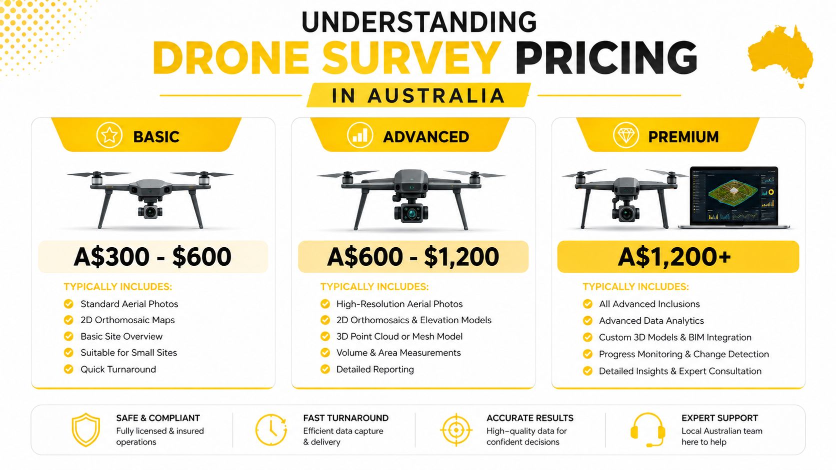
Indicative Australian pricing commonly follows a tiered structure. Surveys for small sites under 5 hectares are often quoted at A$500–A$1,500, while medium sites from 5 to 50 hectares commonly fall between A$1,500 and A$5,000. Large sites above 50 hectares generally start at A$5,000, and complex LiDAR work can exceed A$30,000, according to an Australian drone surveying pricing guide (Australian drone surveying pricing guide) and Australian market benchmarks (National Drones inspection cost benchmarks).
These figures are useful for budget planning, not for accepting a quote without checking its scope. A small, open stockpile measured with photogrammetry is a very different service from a vegetated site requiring LiDAR, additional control, extensive processing, and a formal technical package.
Why comparable sites produce different quotes
The deliverable defines the job. Raw images require less processing than a georeferenced orthomosaic. An orthomosaic is less demanding than a digital terrain model, cut-and-fill analysis, classified point cloud, or CAD-ready survey package. Each additional output creates more office work and introduces more quality checks.
The sensor also changes the commercial calculation. Photogrammetry is often suitable for open, well-defined areas where image overlap can support mapping and measurement. LiDAR becomes relevant where vegetation, terrain, or required ground information makes imagery alone unsuitable. An Australian guide indicates that LiDAR typically adds 30–50% to photogrammetry pricing, while rush processing can add 20–40% (Australian drone survey guide). The same guide notes that recurring monthly progress surveys can be 20–40% cheaper per survey because mobilisation and setup costs are spread across multiple flights.
Practical rule: A quote should identify the data product, accuracy expectation, sensor, control method, processing scope, and exclusions. A single lump sum without those details isn't a meaningful comparison.
For an early budget check, a project team can use the drone survey quote calculator, then request a provider quote based on the actual site and deliverables.
Key Cost Drivers That Shape Your Quote
The largest pricing mistakes happen when a client describes the site but not the intended use of the data. A provider needs to know whether the output will support visual reporting, stockpile measurement, design coordination, earthworks verification, asset inspection, or another technical decision.
The variables that move the budget
Site area affects flight planning, battery logistics, field time, processing volume, and quality assurance. Area alone isn't enough. Slopes, vegetation, buildings, powerlines, restricted access, active work zones, and difficult launch locations can make a small site harder than a larger open one.
Sensor selection is another major divider. Photogrammetry uses overlapping imagery to produce mapping outputs such as orthomosaics, surface models, and models suitable for measurement. LiDAR uses laser returns and is selected when terrain information beneath vegetation or more consistent ground capture is required. The Australian market shows LiDAR survey pricing commonly around A$2,000–A$8,000 per site, while large-area mapping can reach A$5,000–A$30,000+ (Australian drone inspection cost benchmarks).
Ground control can be a separate line item rather than part of the flight fee. Ground control points, checkpoints, RTK, or PPK workflows affect positioning confidence and verification. Australian market guidance places ground control at an additional A$500–A$2,000 where it is required (Australian surveying and mapping pricing guide).
Reading the quote line by line
| Cost Driver | Typical Impact | When It Applies |
|---|---|---|
| Site area and terrain | More field planning, capture, processing, and quality assurance | Larger, steep, obstructed, or difficult sites |
| Photogrammetry | Usually the simpler sensor option for open areas | Orthomosaics, surface models, visual mapping, and many volumetric tasks |
| LiDAR | Higher equipment and processing requirement | Vegetated terrain, demanding terrain capture, or LiDAR-specific outputs |
| Ground control | Additional field and survey work | Accuracy verification, control points, and projects needing stronger positional confidence |
| Deliverables | More office time and technical review | CAD files, reports, classified point clouds, models, contours, and calculations |
| Rush processing | Premium for compressed turnaround | Urgent construction, operational, or reporting deadlines |
| Travel and mobilisation | Additional logistics and field time | Remote, regional, or difficult-to-access Australian sites |
| Airspace and site controls | More planning and operational coordination | Controlled airspace, sensitive locations, active industrial sites, and complex risk environments |
A provider's software stack also matters. Processing raw imagery into an orthomosaic is one task. Cleaning data, classifying points, checking errors, calculating volumes, and producing files that work in a client's GIS or civil design environment is another.
For people beginning a pathway into commercial drone operations, ACE BRONZE is described as a foundation commercial drone course covering drone operations, flight safety, aviation theory, and practical skills for students starting towards becoming licensed drone pilots in Australia. Organisations can also review specialised drone training options where the operational requirement is more specific than a general mapping flight.
Real Project Pricing by Survey Type
Different survey categories create different cost profiles. A stockpile measurement may require a focused capture and calculation, while a mining or infrastructure project can involve larger coverage, stronger control, more complex safety planning, and detailed outputs.
Common project benchmarks
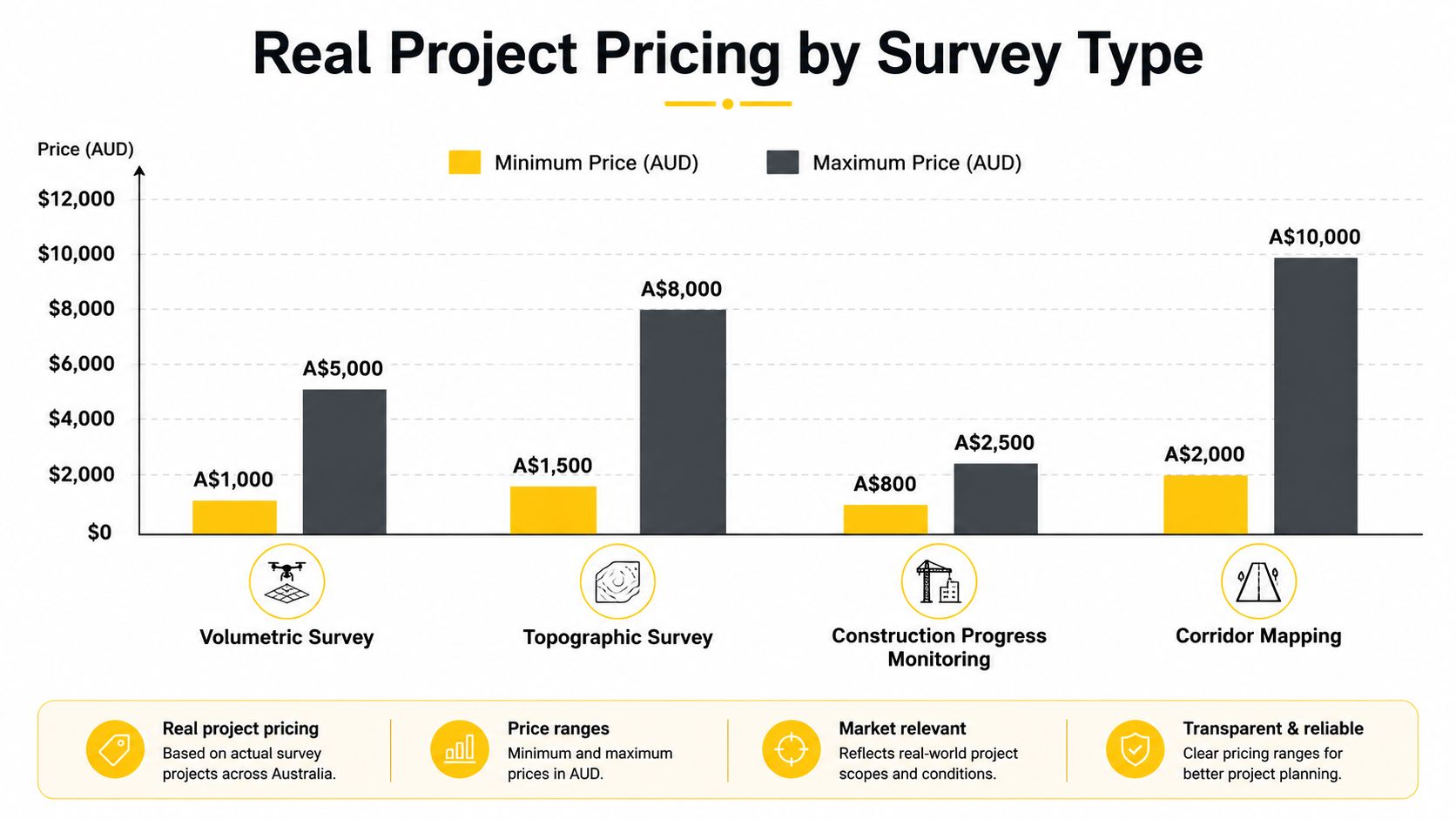
Australian market guidance places a volumetric or mapping visit around A$500–A$2,000, while aerial survey data for small quarries, mines, and landfills is commonly quoted at A$2,000–A$5,000 per site (Australian surveying and mapping pricing guidance). The difference usually reflects site size, the number of stockpiles, control, calculations, reporting, and whether the service is a repeatable programme or a one-off job.
Large or technically demanding surveys can move much higher. A LiDAR survey is commonly placed at A$2,000–A$8,000 per site, and large mapping projects can exceed A$5,000–A$30,000+ (Australian drone inspection cost benchmarks).
Where each billing model fits
| Project type | Indicative Australian pricing | Main budget question |
|---|---|---|
| Volumetric or mapping visit | A$500–A$2,000 per visit | Are calculations and verification included? |
| Small quarry, mine, or landfill dataset | A$2,000–A$5,000 per site | Does the price include control and processed data? |
| LiDAR survey | A$2,000–A$8,000 per site | Is LiDAR necessary for the terrain and deliverable? |
| Large-area mapping project | A$5,000–A$30,000+ | What area, sensor, control, and processing scope apply? |
Hourly billing can be sensible for limited fieldwork, technical advice, or tasks where the scope is still developing. Australian market guidance places professional survey work at around A$175–A$255 per hour (Australian surveying and mapping pricing guidance). A fixed project price is usually easier to manage when boundaries, outputs, and timelines are already defined.
Construction progress mapping often benefits from a repeatable specification. The value lies in producing comparable outputs at each visit, not in ordering a different data package every time. Agricultural and environmental monitoring may also need a consistent capture method, but the appropriate sensor and deliverable should follow the decision being made, not the maximum capability available. Teams assessing agricultural applications can also consider operational context through resources such as Australian agriculture drone information on the XAG P150 Max.
How to Get Accurate Quotes and Compare Providers
A reliable quote begins with a usable brief. “Survey this site” leaves too many commercial and technical decisions unresolved, so providers may price different scopes while appearing to compete for the same work.
Give every provider the same project information
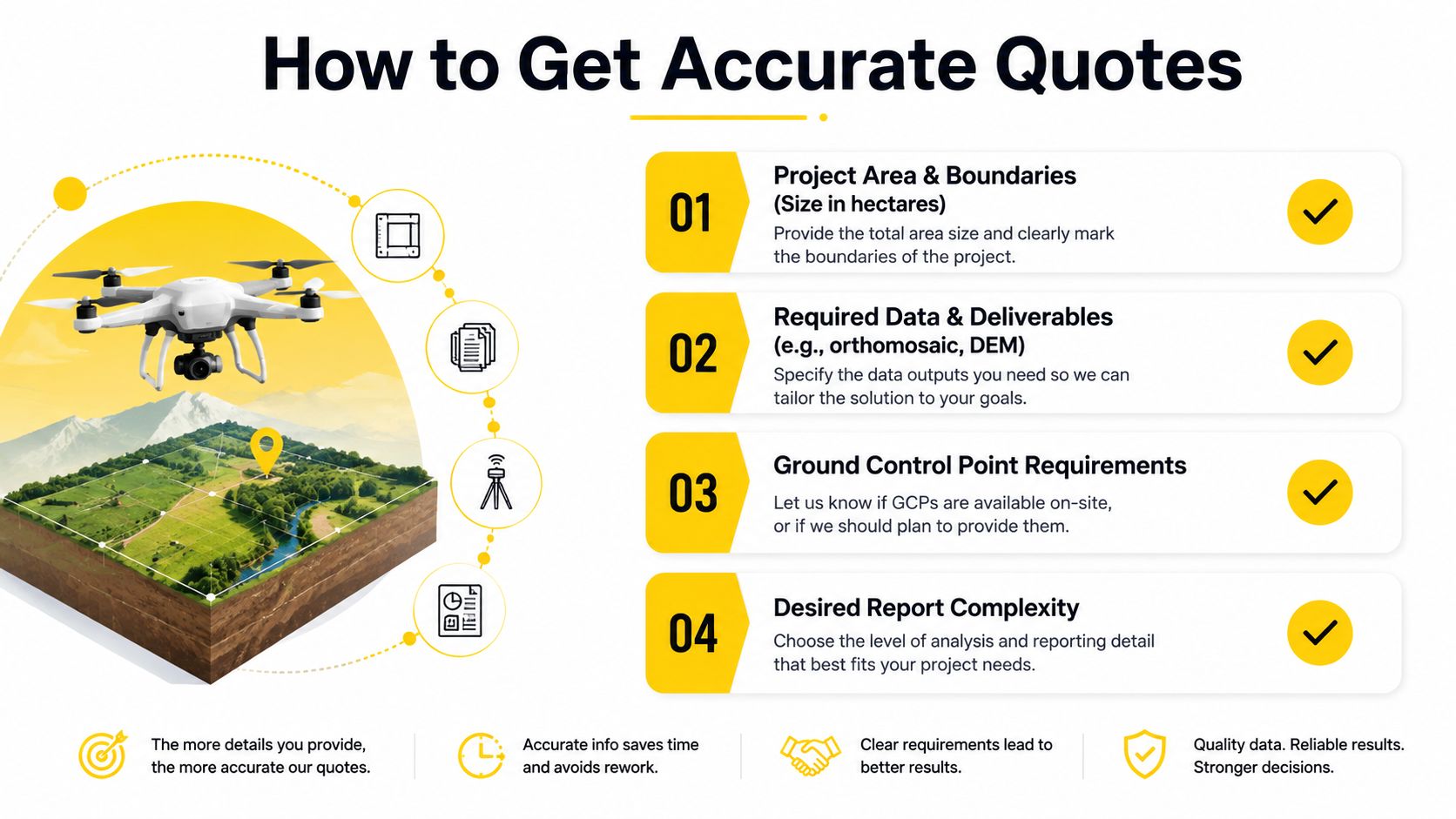
Send a site boundary, access details, preferred survey date, known hazards, and the reason the data is needed. The brief should also identify the required outputs, such as an orthomosaic, digital elevation model, point cloud, volume calculation, CAD file, inspection imagery, or written report.
State the required accuracy in practical terms if the project team has one. If the requirement isn't known, the provider should explain the available options and their implications rather than automatically selecting a high-cost sensor or an inadequate method.
Compare scope, not just the total
A useful quote should make the following visible:
- Capture method: Identify the aircraft, sensor approach, flight conditions, and whether repeat visits use the same method.
- Positioning and control: Confirm whether RTK, PPK, ground control points, checkpoints, or independent verification are included.
- Processing: Ask whether the fee covers data cleaning, alignment, classification, calculations, quality checks, and revisions.
- Deliverable formats: Confirm file types, coordinate reference system, naming conventions, hosted viewers, and retention arrangements.
- Commercial exclusions: Check travel, permits, additional field visits, weather delays, rush work, and changes to the requested outputs.
A pricing questionnaire can help a procurement team standardise how suppliers describe their assumptions. The Formbricks pricing survey options provide a useful reference for structuring questions about price sensitivity and package scope, although the technical brief still needs to come from the project.
Qualifications matter as much as format. CASA-related licensing, insurance, risk controls, site inductions, and the operator's ability to work safely around people and infrastructure should be verified before comparing the final numbers. Businesses developing internal capability can review the drone training quote pathway. For an enterprise-level training scope, ACE PLATINUM is described as a complete package including RePL, AROC, Aviation English, Express ReOC, Certificate III in Aviation, advanced operations training, and preparation to operate and manage a commercial drone business.
A low quote is only cheap if it delivers the data the project actually needs.
Proven Strategies to Reduce Your Survey Costs
The largest savings come from tight scope control, not from forcing a provider to shorten field time. Removing ground control, quality checks, or processing steps can produce data that requires an expensive replacement survey. A low quote is only cheap if it delivers the data the project needs.
Build a recurring programme
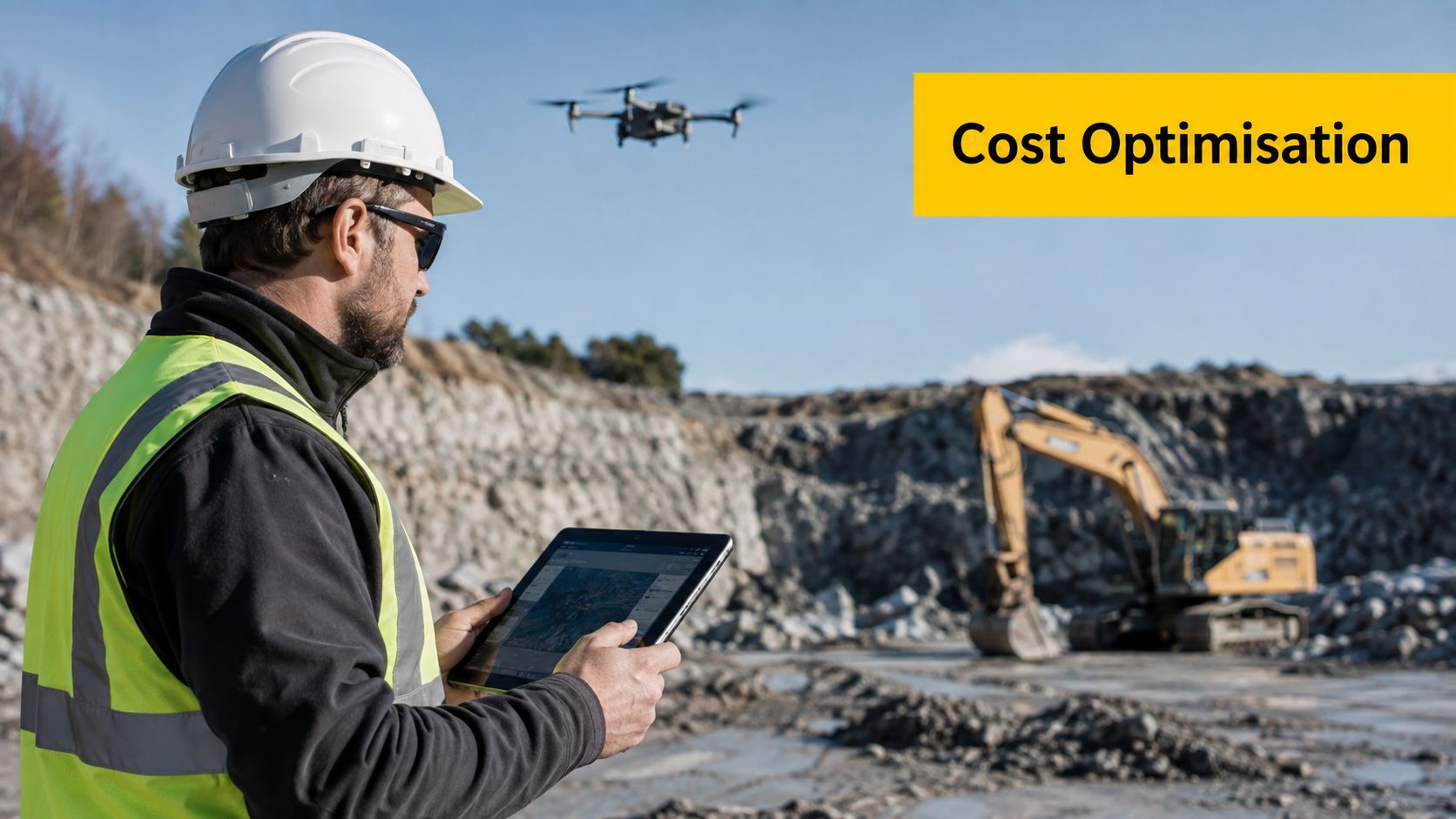
Recurring monthly progress surveys can be 20–40% cheaper per survey than one-off work because setup costs are spread across multiple flights, according to Australian recurring survey pricing guidance. Set the site boundary, flight plan, outputs, naming conventions, coordinate system, and reporting format before the first mobilisation.
This approach also protects consistency. Construction teams can compare each survey directly instead of interpreting changes caused by different altitudes, image resolutions, ground-control methods, or deliverable definitions.
Match the sensor to the decision
Specify LiDAR only when the site conditions or required result justify it. On open ground, photogrammetry may provide the required information at a lower cost. Where vegetation obscures the terrain, choosing imagery alone can trigger rework, supplementary ground survey, or an unusable terrain model.
Ground control is another hidden cost escalator. A quote that excludes control points may look attractive, but the project may then carry weaker positional confidence or pay for a separate control survey. Confirm who supplies the control, what accuracy the deliverable requires, and whether checkpoints are included.
The specification should answer one question: what decision will the data support? Stockpile volumes, progress measurement, design coordination, vegetation analysis, and bare-earth terrain modelling can each require different capture and processing choices.
Remove avoidable urgency
Rush processing can add 20–40% to the survey price. Schedule capture and processing around the reporting cycle instead of treating every flight as an emergency.
Combine adjacent sites into one mobilisation, provide access information before the crew arrives, confirm the deliverable specification early, and avoid late changes to the coordinate system or report format. These controls reduce duplicated planning and office work without weakening the technical output.
Regulatory Requirements and Pilot Qualifications
Commercial drone survey pricing includes more than equipment and software. In Australia, the operator must conduct the work within the CASA framework that applies to the operation, aircraft, location, and operating conditions.
RePL and ReOC responsibilities
CASA's ReOC guidance states that a pilot operating remotely piloted aircraft under a Remote Operator's Certificate, or ReOC, needs to hold a Remote Pilot Licence, or RePL (CASA ReOC and RePL guidance). For many commercial RPAS operations, the RePL is therefore a hard prerequisite rather than an optional credential.
A ReOC relates to the organisation's approved operating framework, while the RePL relates to the remote pilot's qualification. Businesses using contractors should check who holds the relevant approvals and who carries responsibility for the operation. Businesses considering in-house capability need to budget for training, procedures, records, supervision, equipment, maintenance, and ongoing compliance.
Why compliance affects the quote
An appropriately qualified operator must plan the flight, assess risks, manage the site, and operate within applicable limitations. Those activities take professional time, but they protect the client from relying on data captured through an uncontrolled or poorly documented operation.
CASA advisory material indicates that subsequent RePL renewals are typically issued for three years, creating a defined renewal cycle for operators and organisations planning recurrent licensing costs (CASA-related RePL pricing and renewal information). Training and compliance costs can therefore appear indirectly in a provider's rates.
The Remote Pilot Licence pathway is relevant to people seeking the qualification required for commercial RPAS work. For beginners, ACE READY is described as an entry-level course covering drone fundamentals, aviation safety, CASA regulations, flight operations, and preparation for advanced RePL training in Australia.
Planning Your Drone Survey Budget
A project manager can receive quotes thousands of dollars apart for the same site. The difference often sits in ground control, sensor selection, processing urgency, and deliverable scope, not aircraft size. Define the site boundary, intended use, required outputs, accuracy, timing, access conditions, and whether the work is recurring before requesting prices.
Use these Australian pricing tiers as an initial planning range:
- Small site: Under 5 hectares, commonly A$500–A$1,500 per survey.
- Medium site: 5–50 hectares, commonly A$1,500–A$5,000.
- Large or complex site: Above 50 hectares, generally A$5,000+. Complex LiDAR work can exceed A$30,000 (Australian drone inspection cost benchmarks).
Treat those figures as a starting point, not a fixed quote. Ground control may require additional field time and survey equipment. A LiDAR or multisensor package can increase both capture and processing costs. Travel, reporting, rush processing, restricted access, weather delays, and a return visit can also move the final price. Include a contingency for changed deliverables or extra control.
Regular programs require a clear outsourcing decision. Outsourcing suits occasional projects and specialist LiDAR work. Internal capability requires pilot training, procedures, records, equipment, maintenance, compliance, and administration. Enterprise Drone Training or Corporate Drone Training may support that operating model.
The strongest cost control is a precise scope. State what the data must prove, then require each provider to price identical assumptions.
Ace Aviation Aerospace Academy provides CASA-aligned drone education, including the Remote Pilot Licence pathway, aviation training, and organisational options for commercial RPAS operations. Visit Ace Aviation Aerospace Academy before choosing between outsourced surveys and internal capability.
Frequently asked questions
What is the typical drone survey cost in Australia?
Small sites under 5 hectares commonly cost A$500–A$1,500 per survey, medium sites from 5 to 50 hectares commonly cost A$1,500–A$5,000, and large sites above 50 hectares start at A$5,000. Complex LiDAR projects can exceed A$30,000.
Why do LiDAR surveys cost more than photogrammetry?
LiDAR involves a different sensor and processing workflow, and it may be selected for terrain capture where vegetation or site conditions limit imagery. An Australian guide states that LiDAR typically adds 30–50% to photogrammetry pricing (Australian LiDAR pricing guidance).
Can ground control increase a drone survey quote?
Yes. Ground control points and related survey work can add A$500–A$2,000 to an Australian project budget (Australian ground control cost guidance).
Is hourly or project-based billing better?
Hourly billing can suit limited fieldwork or developing scopes. Project-based pricing is usually easier to manage when the site, deliverables, and timeline are clearly defined.
Do commercial drone survey pilots need a RePL?
CASA ReOC guidance states that a pilot operating remotely piloted aircraft under a ReOC needs a RePL, making it a hard prerequisite for many commercial RPAS operations in Australia (CASA ReOC guidance).
How can recurring surveys reduce the cost per visit?
Recurring monthly progress surveys can be 20–40% cheaper per survey because setup costs are spread across multiple flights (Australian recurring survey pricing guidance). The arrangement works best when the site, capture method, control approach, and deliverables remain consistent.
