Buying a drone isn't the best starting point for precision agriculture. The better starting point is a farm decision that can change: which weed patches need treatment, which crop zones warrant inspection, or where an input rate should differ. Without that decision, reliable paddock records and a machine that can use the result, aerial imagery can become an expensive picture rather than a management tool.
For Australian farm managers and remote pilots, the important distinction is between measuring a paddock and applying something to it. Mapping, spraying and spreading involve different equipment, responsibilities and compliance checks. A useful programme connects the agronomist's decision, the pilot's mission and the operator's application records before anyone chooses an aircraft.
Table of Contents
- Five Drone Jobs and the Rules That Change Them
- Why One Paddock Is Never One Rate
- Sensors Matched to the Decision
- How Imagery Becomes a Prescription Map
- Australian Cases from Weeds to National Crop Maps
- What Return Depends on Before You Buy
- Choose the Licence Path for Your Job
- Frequently Asked Questions
Five Drone Jobs and the Rules That Change Them
Precision agriculture manages different parts of a paddock according to measured soil, crop or pest differences. Instead of assuming the whole block needs the same treatment, the farm manager uses evidence to define management zones.
Agricultural drone jobs and what changes the rules
| Job | Main output | What changes the rules |
|---|---|---|
| Crop and soil mapping | Orthomosaic, elevation or zone map | Weight, visual line of sight, and whether the flight stays inside the standard operating rules |
| Weed and pest scouting | Georeferenced anomaly or weed patches | Same flight rules, plus a field check before any chemical decision |
| Prescription mapping | Variable-rate file for a machine or spray drone | Map must match the machine's file format and be verified on the ground |
| Spreading | Granule or seed application | Aircraft capability, pilot competency and operator systems, not just a camera |
| Spraying | Targeted liquid application | CASA operation rules plus state chemical permits; Tasmania requires an RPA spray permit |
The final column includes both aviation obligations and operational safeguards. File compatibility and ground verification aren't substitutes for aviation approval, but they're necessary if a legal flight is to produce a useful agricultural outcome.
An orthomosaic is a stitched, geometrically corrected image that places observations on a map. It can show surface patterns, but a colour camera doesn't directly measure soil fertility. A soil-management zone needs supporting interpretation, such as sampling or existing soil records.
Monitoring isn't application
The Australian Government's agricultural drone guidance estimates that only 10% of Australian agricultural businesses use drones, explains that CASA requirements change with aircraft weight, visibility and the operation, and notes Tasmania's additional permit requirement for remotely piloted aircraft spraying. Registration, operator accreditation and Remote Pilot Licence pathways therefore need checking against the actual job, rather than treating commercial drone use as one approval category.
A scouting pilot might deliver coordinates for suspicious crop patches. A spray operator must also manage liquid delivery, application equipment, chemical handling and the conditions governing that treatment. The ability to fly a mapping mission doesn't establish competency to conduct either spraying or spreading.
Practical rule: A flight approval answers whether an operation may proceed. It doesn't establish that a treatment is agronomically justified or chemically authorised.
For an initial compliance review, the Australian drone laws guide provides a useful orientation. Before selecting a sensor or aircraft, the business should name its row in the table and identify who owns the aviation, agronomy and application responsibilities.
Why One Paddock Is Never One Rate
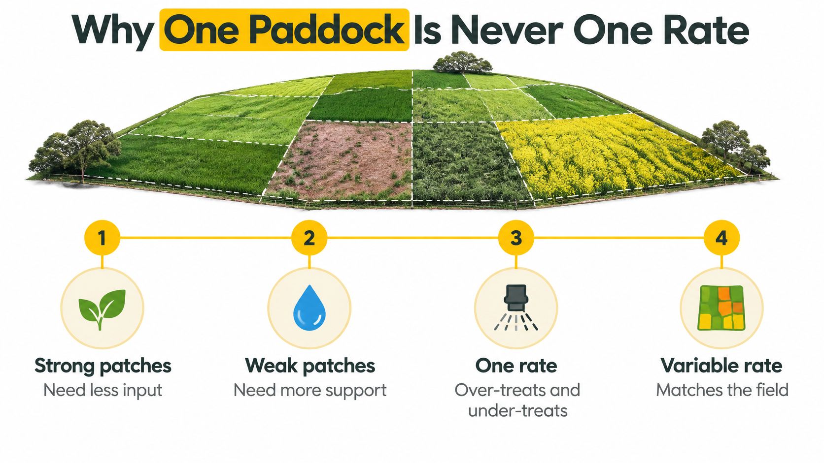
A paddock is closer to a patchwork quilt than a single blanket. Differences in soil depth, drainage, water availability and crop establishment can make neighbouring areas respond differently to the same treatment.
A uniform nitrogen rate might oversupply an area with adequate nutrition while failing to address a responsive deficiency elsewhere. However, weak crop growth doesn't automatically mean more fertiliser is needed. Waterlogging, disease or restricted rooting can produce a similar visual pattern without the same remedy.
The illustration shows the principle of matching management to zones, rather than treating crop colour as a fertiliser recommendation.
Australian experimentation before drone shopping
Australian growers were investigating this variability well before modern agricultural drone workflows:
- Wheatbelt nitrogen trials: In the mid-1990s, Western Australian farmers and researchers ran a chequerboard nitrogen experiment across approximately 70 hectares, according to CSIRO's account of on-farm experimentation.
- Vineyard management: The same CSIRO account describes comparable experimentation in Western Australian wine-grape production in the mid-2000s, including vineyard-floor management and disease control.
- Pasture decisions: By 2009, that account records CSIRO's Pastures from Space supplying weekly pasture-growth-rate information for Western Australian regions using satellite measurements and Landgate data.
These examples share a practical method: measure differences, test an explanation and change management only when the response supports it. Pasture-growth information, for example, can inform grazing rotations and feed budgets without requiring a drone to apply anything.
The existing digital foundation
Drone imagery usually sits above established farm systems rather than replacing them. GPS guidance places machinery accurately, yield monitors record harvested performance, and farm-management software preserves the history needed to interpret a new map.
In an ABARES survey of more than 2,200 Australian farms conducted in 2016–17, 96% of farmers reported owning and using ICT assets, while 95% had internet access. Those historical figures describe a broad digital foundation, not current drone adoption.
The drone is a measuring instrument, not the decision-maker. Sensor selection should therefore follow the paddock question, not an equipment catalogue.
Sensors Matched to the Decision
The useful question isn't which sensor produces the most impressive image. It's whether the measurement can distinguish the condition that matters to the farm manager.
Which sensor answers which paddock question
| Sensor | Best decision | Hard limit |
|---|---|---|
| RGB | Visual scouting, stand counts, obvious damage | No reliable biochemical or disease index by itself |
| Multispectral | Spatial crop-vigour contrasts and zone maps | Needs repeatable altitude, light and calibration |
| Hyperspectral | Disease or biochemical discrimination | Large data volume; often research-grade processing |
| LiDAR | Establishment, canopy structure and terrain | Cost and specialist processing; not a spray map by itself |
Colour, spectral response and structure
RGB is conventional colour photography. It's useful when the question concerns missing plants, storm damage, visible weeds or another feature that a grower can recognise. Reliable plant counts still require suitable image resolution and enough separation between plants.
Multispectral cameras record selected wavelength bands, supporting comparisons in crop vigour. A vegetation index can identify contrasting zones, but it doesn't establish whether the cause is nutrition, moisture, pests or another stress. The appropriate output may be a scouting route rather than an application rate.
Hyperspectral sensing separates reflected light into many narrow bands. CSIRO's account of drone-based environmental and cotton research describes hyperspectral work on disease pressure and genetic resistance, multispectral observations at individual breeding-line scale, and LiDAR measurements of establishment and canopy development. Such discrimination requires a validated analytical method, not just a different camera.
LiDAR measures three-dimensional structure using laser returns. It can help describe canopy height, establishment and terrain, although vegetation cover and survey design affect what ground information can be recovered. A point cloud still needs processing and agricultural interpretation before it supports a treatment decision.
Comparable flights matter more than attractive colours
A single vegetation index isn't a monitoring programme. Establishment observations answer different questions from late-season canopy measurements, so the pilot and agronomist need a growth-stage schedule.
The mission specification should control:
- Altitude and overlap: Keep the observation scale and image coverage consistent.
- Illumination: Avoid comparing strongly different lighting conditions without accounting for them.
- Reflectance calibration: Follow the sensor's calibration procedure so brightness changes aren't mistaken for crop changes.
- Georeferencing: Keep observations aligned with paddock boundaries and the application system.
Equipment measurements need similar discipline. For a tractor-mounted application system with a suspect hydraulic circuit, MA Hydraulics Ltd's resource on troubleshooting hydraulic pressure readings can support the machinery diagnostic process. It doesn't validate an agronomic map or replace checks of spray flow and delivery.
Pick the decision first, then the lightest sensor that can answer it reliably.
How Imagery Becomes a Prescription Map
A prescription map assigns an approved action or rate to a location. It isn't a crop-health image with different colours.
The pilot needs a capture specification, the agronomist needs evidence for the treatment, and the machinery operator needs a file the controller can execute. This workflow keeps those responsibilities connected.
A shared workflow for pilot and agronomist
Write the decision before take-off. Define the target, the detection threshold and who authorises the rate. For example, a weed-detection job needs an agreed rule for which confirmed patches qualify for treatment. Applying a rate without an agronomist-approved threshold turns an observation into an unsupported recommendation.
Plan a repeatable mission. Set altitude, overlap, a suitable lighting window and the sensor-calibration procedure. Include access, obstacles, launch locations and the required aviation checks in the mission plan.
Capture imagery with a positioning method. Use suitable ground control or RTK positioning, and verify alignment against the coordinates used by the tractor or spray aircraft. RTK can improve positioning, but it doesn't remove the need to check the finished map.
Process and inspect the georeferenced layer. Check coverage, image sharpness, alignment and calibration records. Missing strips or inconsistent measurements should trigger rejection or recapture, not interpolation presented as certainty.
Compare independent observations where available. CSIRO's Boorowa Agricultural Research Station combines drones, satellites and ground-based sensors to develop and validate agricultural tools. A farm can apply that principle by checking whether another observation supports the suspected pattern, while accounting for different capture dates and resolutions.
Ground-truth flagged areas. Inspect representative detections and apparently unaffected areas. Record the actual weed, pest or crop condition so false positives don't become unnecessary treatments.
Export and test the machine-readable prescription. Confirm file format, coordinate system, rate units and controller compatibility. A map that won't load has no application value; a small test strip can reveal incorrect placement or rate interpretation before wider treatment.
Record the result. Save the authorised prescription, application record, product quantity, treated area and subsequent scouting or harvest observations. These records provide a baseline for the next decision.
The diagram groups the capture-to-prescription process into its main stages.

An offline handover is still a valid handover
Poor mobile coverage needn't prevent a planned workflow. The team can process imagery at the shed, retain offline copies and transfer the approved file to the controller using a supported local method.
Version control matters more than live upload. The operator should confirm the paddock, approval status and file version before loading the prescription, then retain the application record separately from the planned treatment.
Australian Cases from Weeds to National Crop Maps
Australian examples demonstrate different uses for remote sensing: directing treatment, prioritising pest management and describing agricultural production. Their value comes from what happens after image capture.
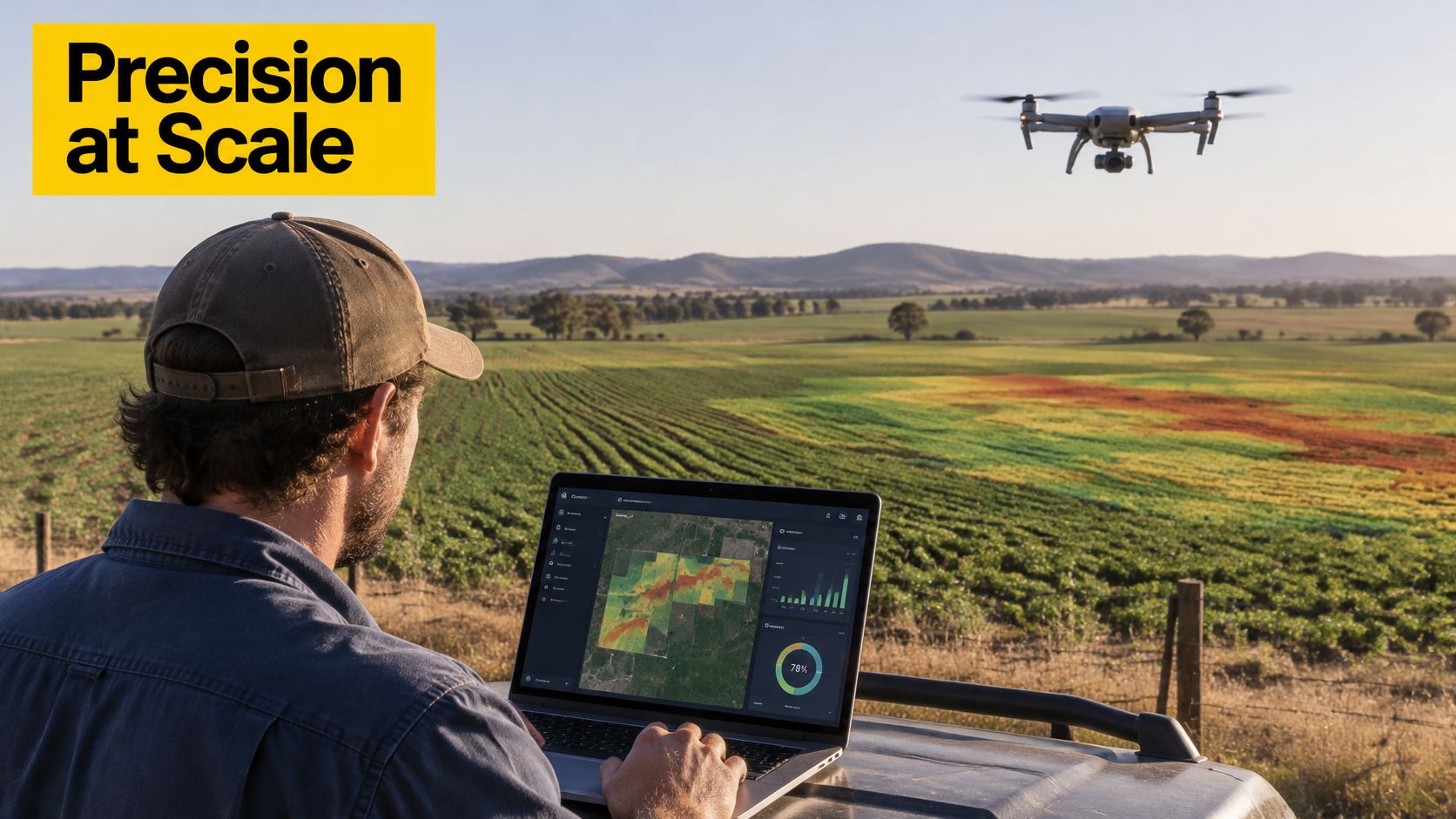
The field workflow places the farm manager's interpretation alongside the pilot's observations.
Weed detection linked to an existing tractor
The CSIRO InFarm case study reports herbicide reductions of up to 95 per cent from an approach combining drone imagery, artificial intelligence and a farmer's existing tractor. That's a reported maximum, not an average or a promise for another paddock.
The important feature is selective treatment: software identifies weed locations and the application equipment acts on that spatial information. Weed size, crop contrast, lighting, ground verification, mapping accuracy and equipment calibration all affect whether the chain works. The case also shows that a monitoring drone can support precision spraying without carrying the chemical itself.
Pest management needs an intervention pathway
A plant-health anomaly can help an agronomist prioritise inspection, but an anomaly alone doesn't identify a pest or establish a chemical response. The useful service includes verified findings and an agreed intervention pathway, not merely delivery of imagery.
For businesses comparing application equipment, the XAG P150 Max Australian agriculture overview provides aircraft-specific context. Aircraft selection should remain separate from the decision about whether treatment is justified.
The following video offers additional agricultural-drone context.
National crop mapping has a different purpose
The Australian Bureau of Statistics' Digital Agriculture Statistics system uses machine learning on satellite data to classify crop types across mainland Australian paddocks, covering 14 significant winter and summer broadacre crops, including wheat, barley and canola. It combines satellite-derived crop-area information with administrative records to produce yearly regional agricultural statistics.
That application supports crop inventories and regional planning rather than directing a particular nozzle. It demonstrates why a national crop classification shouldn't be mistaken for a farm-ready treatment prescription.
Across these scales, the shared lesson is continuity. Sensing must connect to suitable analysis and mapping, followed by controlled application when treatment is the intended outcome.
What Return Depends on Before You Buy
Return should be measured locally through inputs avoided, labour saved, yield protected and application accuracy. A pilot paddock allows the farm manager to compare the proposed method with the existing programme before committing to a larger operation.
Return measures to track on a pilot paddock
| Measure | How to record | Baseline needed |
|---|---|---|
| Chemical or fertiliser not applied | Litres or kilograms per hectare, mapped programme versus uniform programme | Previous season's uniform rate |
| Labour hours saved | Scouting and application hours logged per job | Hours under the current programme |
| Yield protected | Harvest yield by zone against uniform or untreated zones | Yield map or harvest records |
| Map-to-application accuracy | Share of treated area matching flagged zones, checked on the ground | Approved prescription and verified target-zone boundaries |
Previous-season comparisons need care because weather and pest pressure change. Where practical, a suitable comparison strip helps distinguish the treatment effect from seasonal differences.
CSIRO estimates approximately $1 billion in potential economic benefits from applying digital agriculture to weed, pest and disease control across Australian agricultural sectors. That's an economy-wide opportunity, not the return an individual farm should enter into a purchase calculation.
The investment assessment should track these practical outcomes.

Data readiness can be the first constraint
An Australian analysis of agricultural AI adoption identifies the infrastructure needed for paddock-level prediction and precision agronomy: soil sensors, weather information, satellite imagery, digital paddock history and software that integrates those sources. It argues that many grain, mixed-farming and livestock businesses don't yet have that stack.
Cost, integration difficulties, limited knowledge and a shortage of trusted advice can therefore matter more than aircraft availability. Not every scouting job needs the full stack, but advanced prediction can't be assumed to work from a new aerial image alone.
A sensible minimum investment sequence is:
- Organise paddock records: Establish digital boundaries and usable input or yield history.
- Choose repeatable observations: Select imagery that answers a defined management question.
- Prove machine compatibility: Confirm that existing equipment can read and execute the prescription.
- Consider application aircraft last: Add a spray or spread drone when the mapped decision already changes management.
Include the support operation
Ground transport, battery handling, refilling and field checks belong in the labour calculation. The Campus EV farm vehicle guide can inform a separate assessment of farm support transport, without assuming a vehicle purchase will improve drone economics.
The drone business investment planning guide offers further business context, but purchase timing shouldn't replace operational validation.
Go or wait test: Proceed when the team can identify the zone, authorised rate, compatible machine and measurable outcome. Wait when nobody can say which rate will change or why.
Choose the Licence Path for Your Job
A commercial drone job must fit the pilot's qualifications, the operator's approvals and the flight conditions. Flying an aircraft over 2 kg commercially generally requires a Remote Pilot Licence (RePL), though qualifying landholder operations and other excluded-category provisions may follow different rules. Check current CASA requirements for the specific aircraft, landholding arrangement and operation.
A Remotely Piloted Aircraft Operator's Certificate (ReOC) covers the operator and authorised operations. It does not replace a pilot's RePL, and it does not automatically authorise every flight outside standard operating conditions.
Separate aviation competency from chemical authority
An Aeronautical Radio Operator Certificate (AROC) is relevant when aviation radio use is required. For spraying and spreading, also check aircraft-type competency, operator procedures, applicable chemical permissions and product-label conditions.
For a XAG P150 Max spraying business, the pathway includes a RePL, aircraft training and operating under a ReOC. Because the aircraft carries and applies chemicals, additional chemical-application accreditation may also apply.
Training after the operation is defined
Ace Aviation Aerospace Academy offers RePL and AROC training, ReOC consulting, and courses in agriculture, cleaning, night operations and RPAS engineering. The ACE SILVER course is one of its course options. Its XAG P150 Max training and ReOC pathway provides context for agricultural drone operations.
Start by classifying the job and confirming the CASA requirements. Then complete the relevant training, establish the operator systems and test the operation on a pilot paddock.
Frequently Asked Questions
Is precision agriculture only about drones?
No. It can combine GPS guidance, satellite and ground sensors, yield monitoring, digital paddock records and farm software. Drones supply one kind of field data, but their value depends on whether that data answers a farm management question.
Does paddock mapping require a RePL?
Commercial mapping may require a RePL, depending on the aircraft and operating conditions. Check the CASA requirements for the specific flight before choosing a training pathway.
What should a pilot paddock trial measure?
Measure the costs and outcomes that matter to the proposed operation: time spent scouting or applying, area treated, input use and the quality of the result. Compare the trial with the farm's usual method, using the same paddock conditions where possible. A map or flight count alone does not show whether the operation paid off.
Does a drone qualification authorise chemical spraying?
For spraying requirements, see the licence and chemical-authority guidance above.
What should a farm buy first?
Start with the decision the farm needs to make and the paddock records available to support it. Then choose the sensor, aircraft and output that fit that decision. The agricultural drone job-readiness pathway outlines training for agricultural drone operations.
Ace Aviation Aerospace Academy provides remote pilot education and agricultural drone training. Farm businesses and aspiring commercial pilots can contact Ace Aviation Aerospace Academy to discuss training for their intended operation.