

In Australia, small drone mapping jobs commonly start around A$500 to A$1,500, medium sites around A$1,500 to A$5,000, and large or high-accuracy projects around A$5,000 to A$30,000 or more, with specialist hourly rates of A$250 to A$500 ex-GST. The spread is wide because buyers aren't paying only for flight time, they're paying for mobilisation, compliance, survey control, processing, quality assurance and usable data.
A civil contractor might ask for a quick stockpile volume measurement, while a mining superintendent needs a georeferenced orthomosaic, digital surface model and survey-grade report. Both jobs may use a similar aircraft, but they don't create the same operational risk or deliverable. The drone mapping price is determined by what the client needs to rely on after the aircraft lands.
Table of Contents
- What Drives Drone Mapping Price in Australia
- Equipment Costs From Entry-Level to Survey-Grade
- Software, Processing and Data Delivery Costs
- CASA Licensing, Insurance and Compliance Overhead
- Common Pricing Models Buyers Will Encounter
- A Worked Example of a Real Australian Mapping Quote
- Why the Cheapest Quote Is Rarely the Cheapest Outcome
- Practical Ways to Bring Your Drone Mapping Price Down
- Frequently Asked Questions
What Drives Drone Mapping Price in Australia
Drone mapping combines aviation, surveying and information technology. Each discipline adds a separate cost layer. Terrain and vegetation affect capture quality, site access determines mobilisation effort, accuracy requirements influence ground control and equipment, and the requested deliverables determine processing and reporting time. Timing matters too, particularly when a project requires a narrow weather window or coordination with active construction and mining operations.
Australian pricing guides place smaller survey jobs around A$500 to A$1,500, medium sites around A$1,500 to A$5,000, and large-area mapping work around A$5,000 to A$30,000 or more. Hourly specialist work commonly falls between A$250 and A$500 ex-GST. These indicative ranges are outlined in Australian drone inspection pricing guidance, but a buyer shouldn't treat them as a menu of fixed rates.
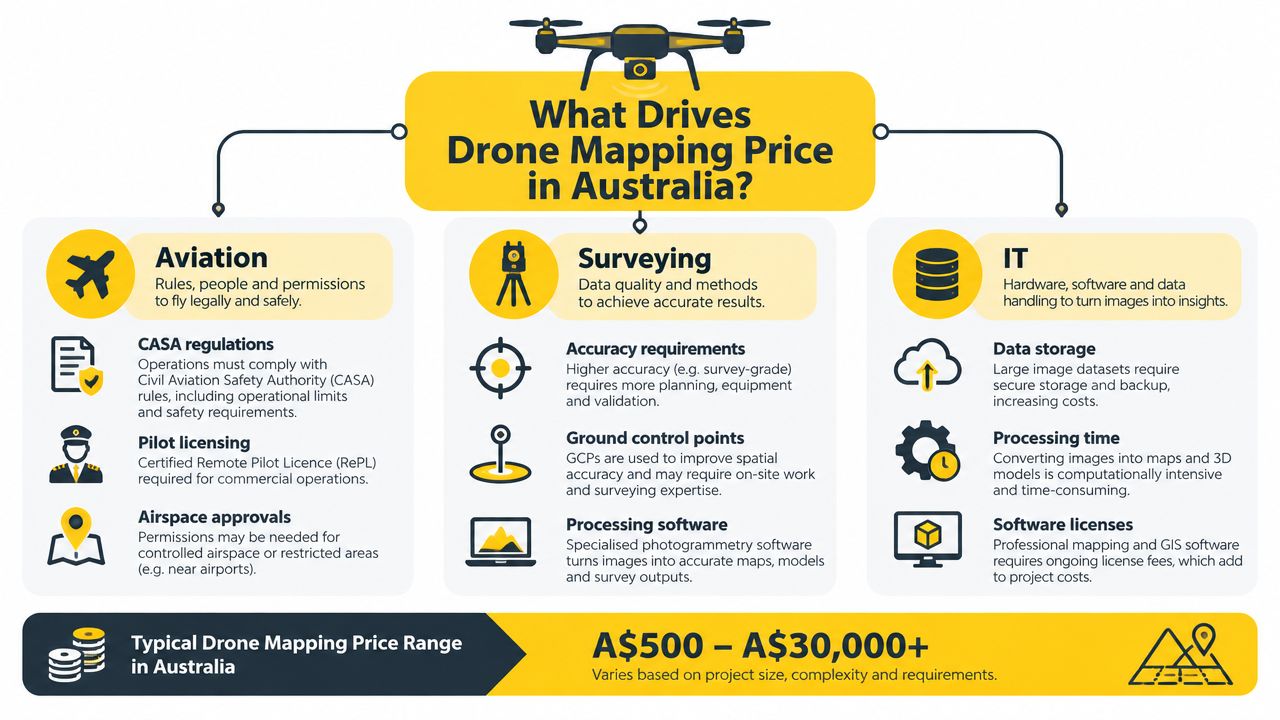
The five cost buckets
A useful quote review separates the invoice into these categories:
- Equipment: Aircraft, camera or LiDAR payload, batteries, GNSS equipment, targets and safety gear.
- Software and processing: Photogrammetry, cloud computing, data cleaning and model generation.
- CASA compliance: Pilot qualifications, operational approvals, insurance, risk assessments and local airspace checks.
- Mobilisation and labour: Travel, accommodation, inductions, site coordination, flight time and survey support.
- Data deliverables: Orthomosaics, contours, digital elevation models, point clouds, volumes, reports and secure delivery.
Consider a contractor in regional Queensland. A stockpile measurement may need a focused flight and a volume calculation. A detailed design survey may require ground control, a registered surveyor, coordinate-reference checks, additional processing and formal QA. The same drone can be used, but the second assignment carries a substantially different specification.
Local access checks can also affect preparation. The Australian Government's Local Drone Rule Map covers 7,610 separate areas managed by 15 responsible authorities, so an operator may need to check more than the obvious airport restrictions before confirming a price. Buyers should also understand the regulatory context through Australian drone laws and operating requirements.
Practical rule: A quote that lists only “drone flight” hides the parts of the workflow most likely to affect accuracy, liability and rework.
Equipment Costs From Entry-Level to Survey-Grade
The aircraft is only one item on the equipment ledger. A consumer drone can capture useful imagery, but it may not offer the mechanical shutter, positioning workflow or payload options needed for survey-grade work. A mapping operator should select hardware according to the output specification, not the aircraft's marketing label.
The entry tier suits visual documentation and basic photogrammetry where the client needs a practical site record rather than a formal survey output. Prosumer systems add mapping-oriented cameras and positioning features. Survey-grade platforms support more demanding coverage, coordinate control and payload requirements, but the asset register expands quickly with field accessories and support equipment.
| Tier | Example Platforms | Indicative Price (AUD) | Typical Accuracy | Best Fit |
|---|---|---|---|---|
| Entry level | DJI Mini 4 Pro | A$1,500 to A$2,500 all-in | Basic photogrammetry, dependent on control and conditions | Small sites, visual records and preliminary mapping |
| Prosumer mapping | DJI Mavic 3 Enterprise, Phantom 4 RTK, Autel Evo Lite+ | A$8,000 to A$25,000 | Improved mapping capability with mechanical shutter and RTK or PPK options | Construction, agriculture and routine commercial mapping |
| Survey grade | WingtraOne, senseFly eBee X, DJI Matrice 350 with L1 or L2 payloads | A$40,000 to A$150,000 or more | Survey-grade workflows when correctly controlled and verified | Mining, large sites, topographic work and complex terrain |
Those hardware figures are indicative planning figures rather than verified Australian market prices. The verified Australian pricing evidence focuses on service outcomes and confirms that accuracy and complexity create step-changes. For example, an Australian provider lists Melbourne feature and contour photogrammetry from A$3,500 for sites under five hectares, while LiDAR starts from A$6,500 for the same site size. The comparison is set out in Australian drone service cost guidance.
Accessories that quietly raise the investment
A serious mapping setup may also require:
- GNSS rover equipment for surveying ground control.
- Ground control point targets that remain visible in imagery.
- Spare batteries and charging systems for field continuity.
- Base stations, controllers and rugged cases for transport and site protection.
- Payload-specific accessories for LiDAR, multispectral or other specialist work.
An operator entering the field should build foundational skills before buying expensive equipment. ACE READY is an entry-level drone training course for beginners covering drone fundamentals, aviation safety, CASA regulations, flight operations and preparation for advanced RePL training in Australia.
The practical recommendation is simple. Use entry-level hardware for non-critical mapping, prosumer equipment for repeat commercial work, and survey-grade platforms only when the specification or site economics justify them.
Software, Processing and Data Delivery Costs
Capturing imagery is the visible part of a mapping job. Processing creates the product the client buys. Raw photographs aren't an orthomosaic, contour plan or volume report, and turning them into those outputs requires licensed software, computing capacity, operator attention and quality checks.
Australian operators may work with tools such as Pix4Dmapper, Pix4Dmatic, DJI Terra, Agisoft Metashape, Trimble Business Center and Esri Site Scan for ArcGIS. The right platform depends on the sensor, coordinate system, required file formats, internal skills and whether processing occurs locally or in the cloud. A buyer shouldn't approve a software name alone. The scope needs to state the actual files and reports included.
Where processing time accumulates
The software bill usually contains three layers:
- Processing licence costs, including desktop licences, subscriptions and add-on modules.
- Compute and storage, including cloud processing, local GPU hardware and secure data retention.
- Professional production, including alignment checks, editing, classification, coordinate validation, export and reporting.
High-resolution imagery can generate substantial datasets. A poor set of ground control points may force reprocessing, while a client requesting an orthomosaic, digital surface model, point cloud and volume report creates more work than a single georeferenced image.
Data delivery also has a practical cost. Clients may need CAD-ready files, GIS-compatible rasters, point clouds, a web viewer, a volume calculation or a written QA report. Each output should appear in the quote, along with the coordinate reference system, expected accuracy, delivery method and retention arrangements.
For broader context on how operators, training providers and technology vendors fit together, readers can review the Australian drone ecosystem.
A low flight fee can still produce an expensive project if the provider hasn't priced the processing, review and data handover properly.
The strongest quote describes the workflow rather than hiding it. It identifies the capture method, control approach, processing responsibility, revision allowance and final deliverables. That makes competing drone mapping prices easier to compare because the buyer is comparing equivalent outcomes.
CASA Licensing, Insurance and Compliance Overhead
A compliant operator has costs before reaching the site. Those costs cover training, operational systems, insurance, airspace checks, safety planning and the administration needed to conduct the flight lawfully. A provider who omits them may appear cheaper, but the buyer could be accepting avoidable operational and contractual risk.
The Remote Pilot Licence, or RePL, is relevant to commercial drone operations requiring the applicable pilot qualification. An Aeronautical Radio Operator Certificate, or AROC, may be relevant where radio operations require it. A Remotely Piloted Aircraft Operator's Certificate, or ReOC, applies to organisations operating under the relevant commercial framework and managing their own approved operations.
CASA requirements depend on the operation, aircraft category, location and operating conditions. Buyers should verify the provider's credentials and operating authority rather than assuming that a drone flight automatically falls within a simple category.
Compliance items that appear inside quotes
| Compliance Item | Typical Cost (A$) | Frequency |
|---|---|---|
| RePL training and assessment | A$2,500 to A$3,500 | One-off training cost, with ongoing competency management |
| RePL renewal | Renewal applies over a five-year cycle | Five-year cycle |
| AROC | Varies by provider and training scope | As required for the operator's duties |
| ReOC application | A$3,000 to A$5,000 | Initial application |
| ReOC manuals and operational systems | Project-dependent | Initial setup and updates |
| ReOC audits | Project-dependent | Annual audit cycle where applicable |
| Aviation public liability insurance | A$1,500 to A$4,000 per year | Annual |
| Approvals, risk assessments and local checks | Project-dependent | Per operation or as required |
The cost ranges above are reflected in Australian service and pricing guidance, including drone surveying and mapping service inclusions, where a starting service price near major CBDs includes a land surveyor, drone operator, quality assurance and secure cloud delivery. Other Australian guidance identifies permits and approvals as a separate cost driver, with indicative survey work beginning around A$1,250 near major CBDs and permit or approval pricing starting around A$1,600, depending on the job.
A legitimate quote may include time for pre-flight risk assessment, landowner permissions, controlled-airspace coordination, site induction and insurance confirmation. Buyers should ask for evidence of appropriate coverage, the operator's RePL details and, where relevant, the organisation's ReOC arrangements.
Training providers such as Ace Aviation Aerospace Academy's RePL pathway are relevant to operators building the qualifications behind compliant commercial work. The buyer's priority should be verification, not the lowest advertised number.
Common Pricing Models Buyers Will Encounter
Australian drone mapping providers commonly price work in four ways. Each model allocates uncertainty differently, so the right choice depends on how clearly the scope can be defined before the aircraft is booked.
| Pricing Model | Typical Price Range | Best For | Risk Bearer |
|---|---|---|---|
| Per hectare | A$15 to A$60 per hectare | Broadacre agriculture, mining and large construction sites | Buyer carries risk on awkward areas and extras |
| Per project | Lump-sum quote | Urban surveys, stockpiles and defined site briefs | Operator carries more scope risk |
| Hourly | A$250 to A$500 ex-GST | Emergency work, complex operations and specialist capture | Buyer carries duration risk |
| Per deliverable | Depends on requested output | Orthomosaics, point clouds, DEMs and volume reports | Shared, if specifications are clear |
The per-hectare model works well when the area is large, accessible and consistent. It becomes poor value for a small, obstructed site because mobilisation, control and approvals don't shrink in direct proportion to the mapped area. A lump sum is usually better for a defined urban site or stockpile measurement, provided the quote states the boundaries, outputs and revision terms.
Hourly pricing suits uncertain work, but the buyer should request a cap or approval trigger. The verified Australian market references place specialist hourly work at A$250 to A$500 ex-GST, while broader service guides place survey and mapping work in project ranges shaped by complexity and processing.
Per-deliverable pricing is the most commercially honest model when the client knows what it needs. An orthomosaic, point cloud, contour plan and volume report aren't interchangeable products. A buyer comparing pricing frameworks and KPIs can also assess whether the requested output supports a measurable business decision rather than merely purchasing attractive aerial imagery.
Before accepting any structure, the buyer should use a written brief covering:
- Site boundary: Include access points, exclusion zones and adjoining areas.
- Accuracy requirement: State the intended use and coordinate reference needs.
- Deliverables: Name file formats, reports and data viewers.
- Timing: Specify capture windows and delivery expectations.
- Extras: Identify travel, re-flight, surveyor sign-off and revision charges.
A quote calculator, such as the drone project quote calculator, can help organise these inputs, but it can't replace a site-specific risk assessment.
A Worked Example of a Real Australian Mapping Quote
A 50-hectare open-cut coal mine in the Bowen Basin needs a 5 cm-accurate orthomosaic, digital surface model, volume report and full survey deliverables. The following is a planning example showing how a quote can be constructed. It isn't a verified market quote, and the individual amounts below are illustrative rather than factual pricing claims.
The brief already signals a substantial project. The operator must account for regional mobilisation from Brisbane, mine access requirements, survey control, equipment selection, processing, QA and the consequences of an unsuitable output. A simple flight-only rate would leave major work unpriced.
| Cost Line | Description | Amount (A$) |
|---|---|---|
| Mobilisation | Vehicle, fuel, travel and accommodation | To be quoted |
| Site access | Induction, coordination and field preparation | To be quoted |
| Field capture | Survey-grade RTK or PPK platform and LiDAR-capable equipment | To be quoted |
| Ground control | GCP placement and survey by a registered surveyor | To be quoted |
| Pilot labour | Two days of specialist flight and site time | To be quoted |
| Processing | Photogrammetry, DSM, orthomosaic and volume calculation | To be quoted |
| Survey QA | Coordinate checks, validation and registered surveyor sign-off | To be quoted |
| Compliance | CASA, insurance and operational preparation overhead | To be quoted |
| Contingency | Weather, re-flight risk and data storage | To be quoted |
| Total | Final project price after site review | A$22,000 to A$28,000 planning range |
The total range above is specified for this editorial scenario, not drawn from verified Australian price data. A commercial operator should replace every placeholder with a documented amount after confirming the site, access arrangements, coordinate system, weather window and mine reporting requirements.
The key lesson is the structure. Mobilisation may dominate a regional job, while survey control and sign-off can matter more than flight time. Processing expands when multiple outputs are required, and contingency protects both parties when weather or data quality prevents a clean first pass.
A registered surveyor's involvement should be explicit if the client needs a formal survey outcome. A drone operator may capture the imagery, but the final legal or engineering use can require professional review and sign-off outside the pilot's role.
Why the Cheapest Quote Is Rarely the Cheapest Outcome
The cheapest headline price often excludes the work that makes mapping dependable. A small site can carry disproportionate mobilisation, setup and compliance costs, while a larger site may spread those fixed costs across a broader area. Australian guidance reflects that pattern, with smaller surveys starting around A$500 to A$1,500, medium sites around A$1,500 to A$5,000, and large work reaching A$5,000 to A$30,000 or more.
Accuracy also changes the job. An image that looks sharp on a screen isn't automatically suitable for volume calculations, design decisions or compliance records. Ground control, RTK or PPK positioning, coordinate checks and documented QA add value because they reduce uncertainty in the final dataset.
| Line Item | Low Quote | Compliant Quote |
|---|---|---|
| Mobilisation | May be excluded or limited | Clearly stated, including travel and site access |
| Pilot qualification | Credentials may be unclear | RePL and relevant operational competency verified |
| Operator authority | ReOC position may be unstated | Operating authority and responsibility documented |
| Insurance | Coverage may be absent or unsuitable | Aviation-appropriate cover confirmed |
| Ground control | Omitted or treated as optional | Method matched to the accuracy requirement |
| Processing | Basic imagery only | Outputs, QA and revision terms listed |
| Survey sign-off | Usually excluded | Included where the intended use requires it |
| Rework | Client may carry the risk | Re-flight and correction responsibilities defined |
An unqualified or uninsured provider can undercut a legitimate operator by avoiding the costs of training, operational systems, insurance and quality assurance. That creates downstream exposure, including inaccurate stockpile volumes, rejected reports, redesign work and disputes over whether the delivered data meets the brief.
Buyer's test: Ask what decision the data must support, then price the accuracy and deliverables required for that decision.
Unit price is a poor comparison metric when the outputs differ. A low-cost orthomosaic isn't comparable with a georeferenced topographic package, even if both quotes use the words “drone mapping”. The buyer should compare total cost of risk, rework and resubmission, not just the amount printed beside the flight line.
Practical Ways to Bring Your Drone Mapping Price Down
Cost reduction is sensible when it removes waste rather than quality control. The safest savings usually come from logistics, preparation and scope clarity. Skipping required compliance or survey control is false economy.
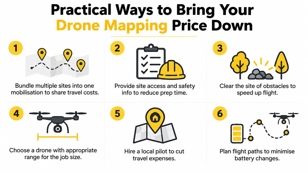
Reduce avoidable field costs
- Bundle nearby sites: One mobilisation can cover several locations when access and timing align.
- Prepare site information: Supply boundaries, hazards, access details, inductions and existing control before the operator travels.
- Choose the right deliverable: Don't order a point cloud or formal contour package if the business decision only needs a measured orthomosaic.
- Use suitable weather windows: Clear planning reduces the chance of a preventable re-flight.
- Coordinate site activity: Keep people, vehicles and temporary obstructions away from the planned capture area.
- Hire locally where practical: A nearby operator can reduce travel and accommodation exposure.
Providing existing survey ground control can reduce duplicated field effort, but the operator must verify that the points are suitable, current and compatible with the required coordinate system. A buyer shouldn't insist on removing GCPs merely to lower the quote when the project needs reliable absolute positioning.
Negotiate the right items
A provider may offer better value for bundled sites, repeat work, off-peak scheduling or a multi-project arrangement. Batch processing can also make sense where several datasets share a workflow. A trade-for-visibility arrangement should only be considered where it doesn't compromise confidentiality, procurement rules, insurance terms or the operator's ability to recover legitimate costs.
The dangerous savings are straightforward:
- Unlicensed pilots: They shift regulatory and liability risk to the client.
- No insurance confirmation: The buyer may discover coverage problems only after an incident.
- Removed QA: Errors can survive into engineering, billing or compliance decisions.
- Under-specified outputs: A cheap file may not work in the client's CAD or GIS system.
For people entering the field, ACE STARTER can be considered as an available training option only after the buyer confirms its current course scope directly with the provider. The essential commercial question remains whether the operator can produce the specified result lawfully and repeatably.
Ask every supplier four final questions:
- What is the expected turnaround for the agreed deliverables?
- Is the quote based on area, project scope, hours or outputs?
- Can the supplier confirm appropriate aviation insurance?
- Is in-house capability cheaper after equipment, training, compliance and processing are included?
Ace Aviation Aerospace Academy provides CASA-compliant drone education relevant to operators who need to understand the regulatory and operational factors behind professional mapping work. Visit Ace Aviation Aerospace Academy to review relevant training pathways for commercial drone operations and compliance planning.
Frequently Asked Questions
How much does drone mapping cost in Australia?
Small jobs commonly start around A$500 to A$1,500, medium sites around A$1,500 to A$5,000, and large or high-accuracy projects around A$5,000 to A$30,000 or more, depending on deliverables, site conditions, compliance and processing.
Why does survey-grade mapping cost more?
Survey-grade work can require RTK or PPK positioning, ground control, specialist sensors, heavier processing, quality assurance and surveyor involvement. Buyers pay for dependable, documented outputs rather than aerial photographs alone.
Is drone mapping priced per hour or per project?
Both models appear in Australia. Specialist hourly rates are commonly indicated at A$250 to A$500 ex-GST, while project-based quotes are common for defined sites and deliverables. Per-hectare and per-deliverable pricing are also used.
Should a buyer ask for CASA and insurance evidence?
Yes. The buyer should verify the operator's relevant RePL credentials, operating authority where applicable, insurance and site-specific compliance arrangements before approving the work.
Is it cheaper to hire an in-house drone operator?
It can be for frequent, repeatable work, but the comparison must include aircraft, payloads, batteries, software, processing hardware, training, insurance, compliance systems and staff time. Outsourcing may be more economical when projects are occasional or technically demanding.
