

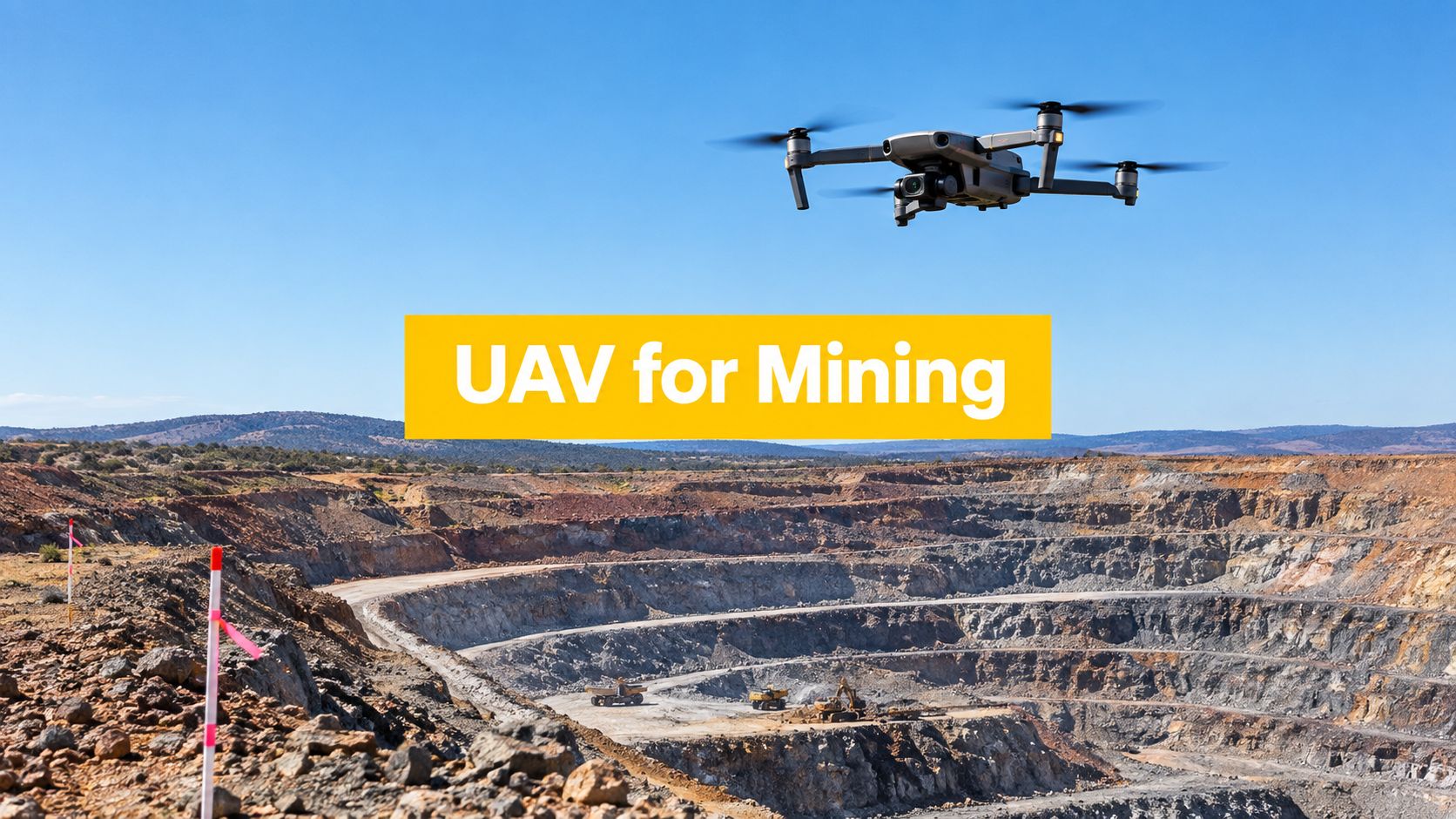
A mine survey team arrives before first light. The pit is deep, haul trucks are already moving, and the task sounds simple on paper: update volumes, check a wall condition, and give operations fresh data before the next shift change. The problem is that simple mine jobs rarely stay simple once altitude limits, radio procedures, exclusion zones, and moving plant enter the picture.
That's where UAV for mining has changed daily practice in Australia. Drones let operators capture current site data without sending people into every hazardous area, but useful results depend on more than flying a grid. The pilot needs to understand the sensor, the survey method, and the CASA rules that apply once the mission moves beyond a basic visual line of sight job.
For Australian operators working near pits, stockpiles, haul roads, tailings infrastructure, or underground voids, the difference between a clean workflow and a problematic one usually comes down to planning discipline. It also comes down to understanding site context, especially in remote operations such as those discussed in Beyond the Bitumen, where logistics and communications shape every aviation task.
Table of Contents
- Introduction to UAVs in Australian Mining
- How UAVs Work for Mining Operations
- Key Mining Applications and What They Deliver
- CASA Rules and Training Requirements for Mining UAVs
- Recommended Workflow from Planning to Data Handover
- Australian Case Studies and Lessons for Operators
- Conclusion and Frequently Asked Questions
Introduction to UAVs in Australian Mining
Australian mining didn't adopt drones as a novelty. It adopted them because large sites need current spatial data, repeated inspections, and safer ways to look into places people shouldn't enter unless they must.
A typical open-cut example makes the shift easy to understand. A traditional ground crew can measure a stockpile or check part of a pit, but that takes site access, traffic coordination, and exposure to active work areas. A drone crew can collect imagery or LiDAR from a stand-off position, then turn that data into maps, surfaces, and measurements for survey or engineering teams.
The scale of adoption shows that this is already established practice. An Australian government economic benefit analysis states that mining could account for about 5,700 drones at saturation by 2030, and between roughly 2,400 and 3,400 drones in mining by 2040 under low-to-high uptake scenarios. The same report says drones are already used in mining for inspection, mapping, stockpile management, and road and dam management, and estimates A$18.435 billion in economic benefit from the mining sector across 2020 to 2040. It also notes there were 7,565 mining enterprises in 2019, which shows the technology sits inside a broad national industry rather than a handful of showcase sites (Australian drone economic benefit analysis).
Where mining drones fit on site
Mining drone work usually falls into a few operational groups:
- Survey and mapping work for orthomosaics, contours, and surface models
- Volume tasks for stockpiles, pits, and reconciliation support
- Inspection flights around roads, dams, walls, and fixed infrastructure
- Safety-focused observation where operators need visual awareness without sending people closer
- Underground mapping in GPS-denied environments using specialist systems
Practical rule: In mining, a good drone mission isn't just a flight. It's a controlled data-collection job with a clear output and a site-specific safety method.
The technology is mature enough to be operational, but mining adds complications that many general drone guides skip. Deep pits affect altitude interpretation. Active excavations change risk planning. Repeated missions across large sites raise questions about governance, observer arrangements, and when a business needs a stronger certification framework rather than an ad hoc pilot-led setup.
How UAVs Work for Mining Operations
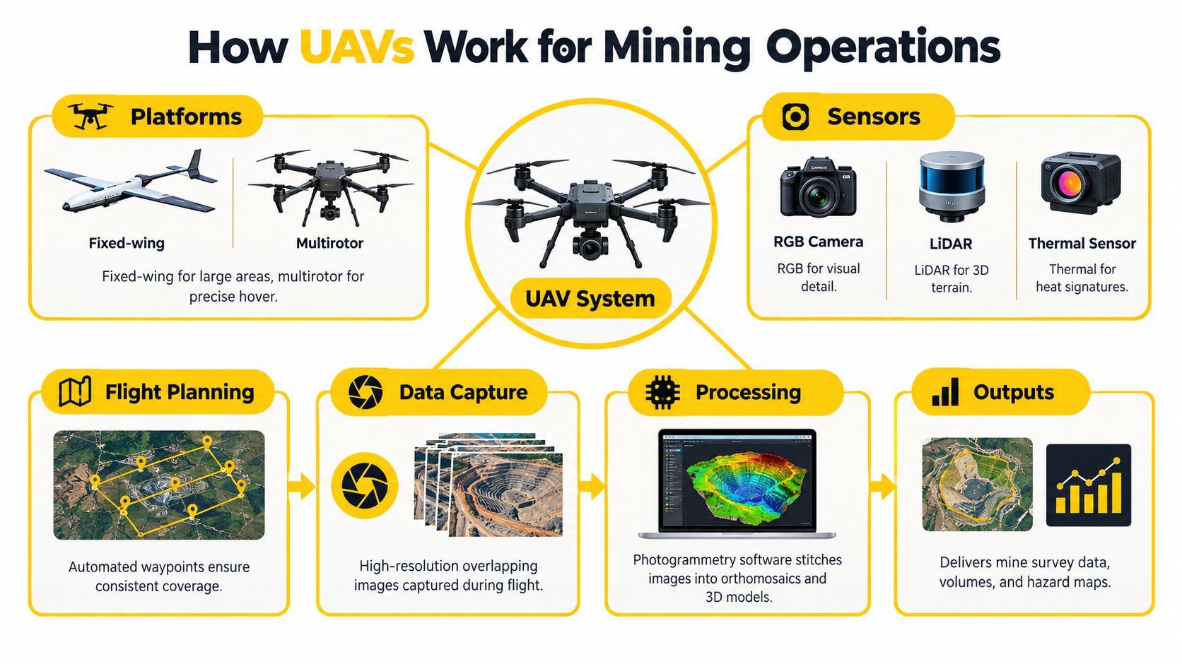
A mining drone system is best understood as a chain. The aircraft carries the sensor. The sensor captures data. The navigation and control method determines how consistently that data is captured. The processing software turns the raw files into something the mine can use.
The basic system on a mine site
Most UAV for mining operations use one of two platform types:
- Multirotor aircraft for tighter areas, hover work, inspections, and smaller survey blocks
- Fixed-wing aircraft for broader coverage where runway-free launch methods and large-area efficiency suit the task
The sensor choice matters just as much.
- RGB cameras support photogrammetry, visual inspection, and surface modelling
- LiDAR payloads help in complex terrain, vegetation-affected areas, or where direct 3D capture is preferred
- Thermal sensors can support selected inspection and monitoring tasks, depending on the objective
For pilots trying to build foundations before moving into technical mine work, ACE READY is an entry level drone training course for beginners covering drone fundamentals, aviation safety, CASA regulations, flight operations, and preparation for advanced Remote Pilot Licence training in Australia.
How images become mine data
Photogrammetry works by taking many overlapping images and matching common points across them. A simple way to think about it is this: each photo is only one view, but a large set of overlapping photos lets software reconstruct shape, elevation, and position.
That only works well when the collection method is disciplined. The mining case study in the Institute of Mine Surveyors proceedings reported an average volume difference of about -1.4%, RMSE of 2.3%, and maximum volume errors below 9.0%. The same study makes the practical point that accuracy is strongly affected by image overlap, ground resolution, camera calibration, and georegistration quality (mining UAV photogrammetry case study).
A pilot who skips calibration or uses weak control points doesn't just create messy outputs. That pilot creates reconciliation problems for the surveyor who has to trust the surface.
Control links and operational range
Mine operators often focus on aircraft and camera specs first, but communications hardware also matters, especially where remote data links or telemetry accessories are involved. For operators researching components used in connected field systems, wireless module antennas at DigiDevice are one example of the kind of hardware category that appears in broader UAV communications setups.
Beyond the aircraft itself, the pilot also needs to understand the difference between a straightforward visual line of sight task and a more complex operating concept. Once the mission starts stretching over distance, terrain, or repeated automated routes, the conversation quickly moves toward approvals and operating frameworks associated with BVLOS operations in Australia.
Good mine data starts before take-off. The flight line, overlap, control quality, and capture method usually determine whether the deliverable is survey-grade useful or just visually impressive.
Key Mining Applications and What They Deliver
Mining sites use drones for many different jobs, but each job has a different output. That's where newer pilots often get confused. The aircraft may be the same, yet the workflow for a stockpile survey is not the workflow for a wall inspection or an underground void map.
Surveying and mapping
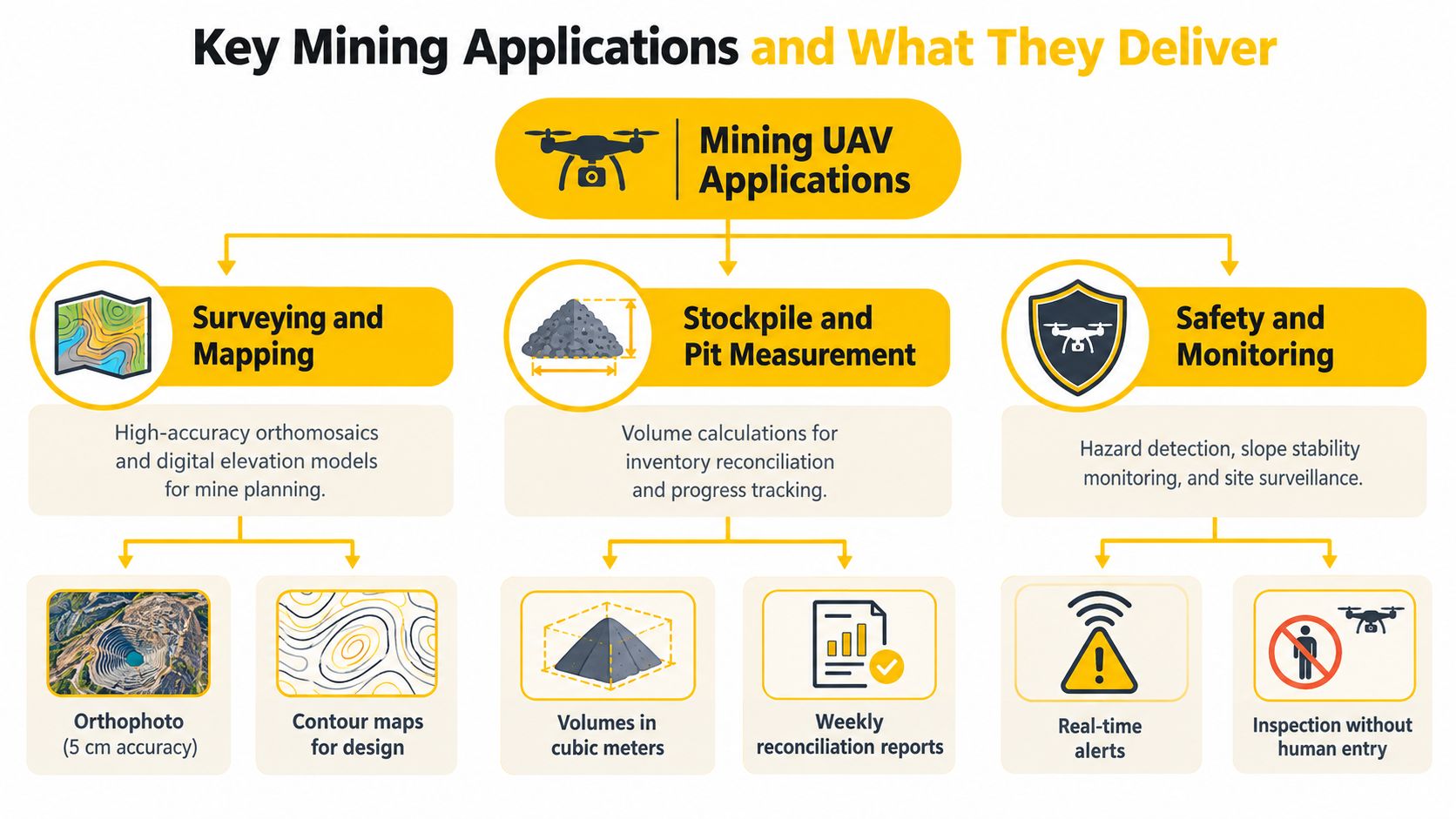
Surface surveying is the most familiar mining drone task. Operators fly planned lines with sufficient overlap, then process the data into orthomosaics, elevation models, and surfaces that mine planners or survey teams can use.
This suits:
- Pit progression checks
- Haul road condition mapping
- General site topography updates
- Surface change comparison across time
The key delivery isn't “drone footage”. It's a georeferenced product that another department can trust.
Stockpile and pit measurements
Volume work is one of the clearest business uses for a UAV for mining. The drone captures a current surface, and the mine compares that surface against earlier models, design surfaces, or inventory expectations.
This supports:
- Stock reconciliation
- Production tracking
- Pit development monitoring
- Material movement analysis
Where operators struggle is assuming volume output is automatic. It isn't. Volume quality depends on overlap, sensor behaviour, ground control, and clean processing decisions, as noted earlier in the mining photogrammetry results.
Inspection and monitoring
Not every mining drone task is a survey. Some jobs are observation-heavy rather than measurement-heavy.
Examples include:
- Road and drainage inspection
- Tailings or dam visual checks
- Bench and wall observation
- Post-blast review from safer stand-off positions
- General security and perimeter awareness
For readers comparing drone monitoring with broader site protection practice, site security tips from GM GROUP Services provide useful context on how monitoring fits into overall industrial site oversight.
Underground mapping and hazardous voids
Underground mining introduces a different problem. GPS is unavailable, sight lines are restricted, and the operator often needs information from stopes, ore passes, or voids that are unsafe or inefficient to inspect directly.
CSIRO-linked autonomous UAV systems using LiDAR and SLAM have been used to generate 3D maps in GPS-denied stopes and ore passes in minutes, and one CSIRO example reported a traditional CMS scan taking up to three hours versus 15 minutes with Hovermap. The operational significance is obvious. Fewer people need to approach hazardous voids, and the mine gets faster geotechnical and post-blast data for over-break, under-break, and volume reconciliation (CSIRO underground drone mapping example).
Field note: The right mining drone workflow starts with the question, “What decision will this data support?” That question usually determines the sensor, flight pattern, and processing standard.
Choosing the Right UAV Application for Your Mining Task
| Mining Task | Recommended Sensor and Output | Key Accuracy Driver |
|---|---|---|
| Surface topographic survey | RGB camera with orthomosaic and surface model | Image overlap and georegistration quality |
| Stockpile measurement | RGB photogrammetry with volume model | Ground control quality and camera calibration |
| Pit progression review | RGB or LiDAR with current terrain surface | Flight planning consistency across repeat missions |
| Wall or infrastructure inspection | Visual sensor output, stills, and inspection imagery | Safe stand-off position and stable capture angle |
| Tailings, road, or drainage monitoring | RGB mapping or visual inspection output | Repeatable route planning and clear hazard boundaries |
| Underground void mapping | LiDAR and SLAM-based 3D map | Reliable navigation in GPS-denied space |
CASA Rules and Training Requirements for Mining UAVs
A mining site may feel private and controlled, but CASA rules still apply. Many pilots get caught by this early. They assume that because the site is remote, the operation is automatically simple. It often isn't.
Standard operating conditions on mine sites
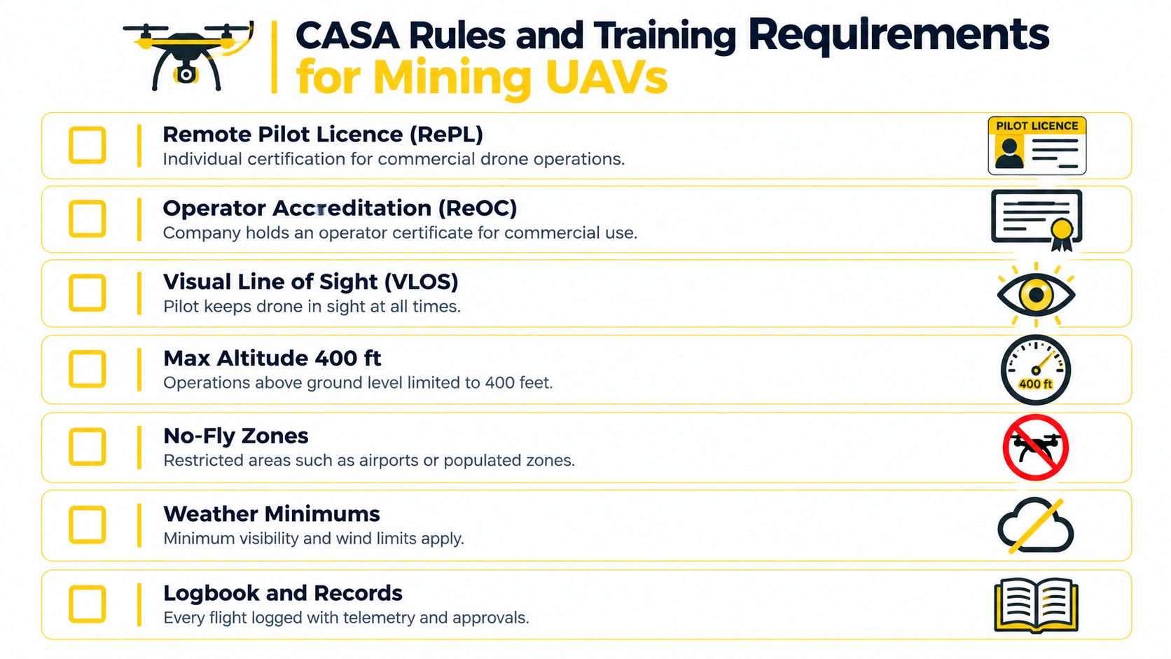
Under CASA's standard operating conditions, drone flights must remain within visual line of sight, stay at or below 400 ft (120 m) above ground level by day, remain at least 30 metres from people not directly associated with the operation, and avoid controlled aerodromes, populous areas, prohibited areas, and specified restricted areas unless approval has been obtained (CASA standard operating conditions).
Those rules matter in mining because routine jobs often drift toward complexity:
- Deep pits can create altitude confusion
- Moving plant changes separation and risk management
- Large sites can tempt crews to stretch visual line of sight
- Radio coordination becomes critical when aircraft and vehicles share an active work environment
When a mining job needs more than standard conditions
A pilot should think in two layers. First, can the job be flown under standard conditions? Second, if not, what approvals, qualifications, and operating structure are needed?
For heavier aircraft, the Australian Parliament's RPAS review notes that for RPA weighing between 25 kg and 150 kg, the operator needs to hold a RePL in the category of aircraft being flown, while standard operating conditions still apply unless a higher approval is granted. The same source also restates the 5.5 km buffer from the movement area of a controlled aerodrome, the 30 m separation from uninvolved people, and the prohibition on operating over public-safety or emergency operations without approval (Parliamentary RPAS review extract).
For companies building repeatable mining programs rather than one-off jobs, a stronger operator framework often becomes necessary. That's where internal manuals, approval pathways, and certification planning matter, which is the practical space covered in this guide to ReOC in Australia.
Deep pits, excavations, and the buffer rule
One of the most misunderstood mining issues is flying above a deep excavation. Many site teams ask whether they can fly higher inside a pit because the floor is far below the surrounding ground level.
CASA's consultation material highlights the current friction point. Operations above 400 ft AGL still require CASA approval and a NOTAM, while proposed relief for active mining excavations would measure altitude from the pit edge rather than the pit floor. The proposal would still require RePL, AROC broadcasts, VLOS, and usually ReOC-level authorisation for BVLOS or EVLOS contexts. That means the proposed change doesn't create a free-for-all. It may reduce friction for some pit operations, but it preserves a structured safety case around airspace coordination and operating conditions (CASA consultation on mining excavation relief).
A second mine-specific planning rule appears in CASA's broad-area BVLOS guidance. CASA sets a minimum 1:1 ground-risk buffer ratio, meaning the horizontal buffer must be at least equal to the maximum operating height. For a 400 ft (120 m) operation, the buffer is also 400 ft (120 m). CASA also states that for operations over an active mining operation, a 400 ft ground-risk buffer applies regardless of height while operating over excavated areas (CASA broad-area BVLOS guidance).
Quick decision table for operators
| Operating situation | Likely baseline | What usually triggers more approval |
|---|---|---|
| Small visual survey in a clear area | Standard conditions may suit | Nearby uninvolved people, aerodrome proximity, or restricted airspace |
| Mapping inside or around a deep pit | Needs careful altitude interpretation | Above-400-ft issues, pit-edge rule questions, and active excavation constraints |
| Long corridor or repeated autonomous route | Standard VLOS may not suit | BVLOS or EVLOS concepts, communications planning, operator governance |
| Heavy aircraft operation | Depends on aircraft category and approvals | RePL category requirements and broader certification needs |
| Active site radio environment | Pilot qualifications alone may not be enough | AROC needs and formal site communication procedures |
Mining compliance isn't just about the drone. It's about whether the whole operation, including height reference, people, vehicles, radio use, and airspace coordination, remains inside the approval you actually hold.
Recommended Workflow from Planning to Data Handover
A repeatable mining drone workflow should look boring on paper. That's a good sign. Predictable systems reduce surprises, and surprises are what damage both safety and data quality.
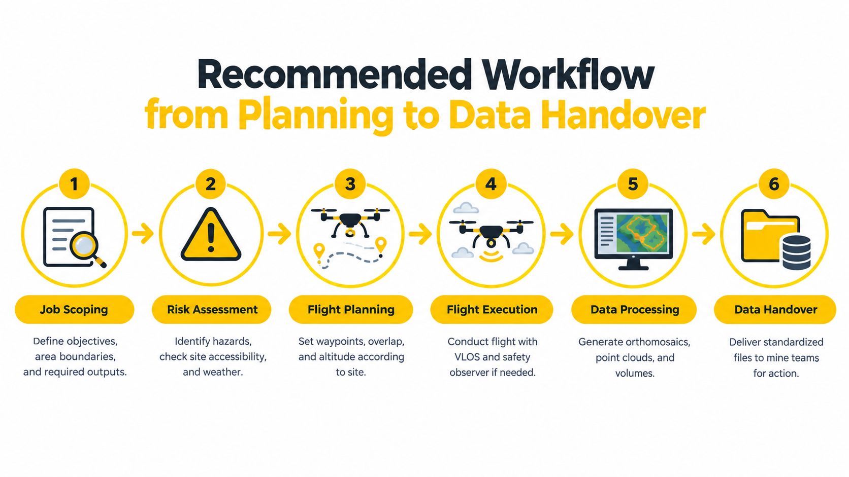
Step 1 to Step 3 on site
Scope the job clearly
Define the task before selecting the aircraft. A stockpile reconciliation mission needs different outputs from a wall inspection or post-blast review.Assess the operating environment
Check people, vehicles, haul routes, airspace, terrain masking, and whether the task stays within standard conditions. If the operation is near sensitive airspace or helicopter activity, site teams should also understand broader operational safety guidance such as this article on drone safety near airports and HLS in Australia.Prepare control, communications, and flight lines
Set ground control where required, confirm radio procedures, and build the route with enough overlap for the intended output. If the operation sits in an active mine communications environment, the need for an AROC may become practical very quickly.
Step 4 to Step 6 after launch
Execute the mission to the plan
Fly the route, monitor the site, and stop if the environment changes. In mining, a clean abort is part of good airmanship, not a failure.Process and quality-check the data
Review completeness before handing anything over. Missing coverage, poor tie points, or control issues are easier to catch early than after the surveyor questions the model.Deliver the right files to the right team
A mine usually needs more than screenshots. Survey teams may need surfaces or point clouds. Geotechnical staff may need 3D context. Operations may only need an annotated map.
Common workflow mistakes
- Weak mission definition leads to the wrong sensor or output
- Poor control placement undermines otherwise good imagery
- Loose radio discipline creates avoidable operational risk
- Overstretching VLOS assumptions pushes the mission outside its real approval basis
- Inconsistent repeat flights make change detection less reliable
A mine doesn't need more drone flights. It needs drone flights that produce defensible outputs and can be repeated the same way next week.
For businesses scaling beyond occasional contractor jobs, a governed structure matters. That may include ReOC procedures, standard work instructions, recurrent training, and enterprise documentation. In that context, Ace Aviation Aerospace Academy offers relevant Australian training pathways such as Remote Pilot Licence (RePL), Aeronautical Radio Operator Certificate (AROC), Enterprise Drone Training, Corporate Drone Training, and ReOC Consulting for organisations that need formal capability rather than informal site flying.
Australian Case Studies and Lessons for Operators
A new pilot arrives at a remote open-cut site expecting a straightforward mapping job. By the end of the shift, the lesson is clear. Flying the aircraft is only one part of mining operations in Australia. The harder part is fitting each flight into pit geometry, site radio procedures, approval limits, and a workflow the mine can repeat next week without rethinking everything from scratch.
Australia gives operators some useful case studies because the local mining sector adopted UAVs in stages. Early work focused on inspection, mapping, and targeted problem-solving rather than full autonomy from day one. CSIRO described that progression, including a world-first underground drone test at South32's Cannington mine in Queensland using Hovermap, in its article on drones and apps in mining. That example matters because it shows a mine using a drone to reach a place that is difficult, slow, or unsafe to inspect on foot.
The lesson for new commercial pilots is simple. Mining companies usually do not need a drone for its own sake. They need a repeatable result such as a void model, a wall inspection record, or a survey update that supports a real site decision.
Australia's mining sector is also mature enough that operators should expect structured expectations from day one. Industry forecasts have described mining as the country's largest drone-flight sector, with strong long-term growth projected by sector analysts at Deloitte Access Economics in its drone market forecasting work for Australia. For a pilot entering this field, that usually means the conversation starts with reliability and governance, not novelty.
That shift from occasional flights to routine operations is where many guides stay too general. On an Australian mine, scaling a UAV program often means handling questions that sound small but change the whole operation. Can the task stay within visual line of sight from the pit rim or does terrain break sight lines? Does a proposed route need a 1:1 horizontal buffer in a BVLOS planning context? If the aircraft is working in a deep pit, how does the vertical profile interact with CASA approval settings rather than the simple idea of "400 ft above ground"?
Those details decide whether a task remains a one-off survey or becomes part of a governed operating system.
CASA consultation material points toward broader standardised pathways for some BVLOS activity, including use cases relevant to remote industries such as mining, but the practical burden still sits with the operator to show safe procedures, clear responsibilities, and suitable oversight (CASA consultation overview). In plain terms, autonomous capability does not remove operational discipline. It raises the value of it.
A useful comparison is to treat a mine drone program like a haul-road routine. One successful run proves the route is possible. Repeating that run every day, with the same checks and tolerances, is what makes it operational. The same applies to UAV work. The milestone is not the first successful autonomous flight. It is the point where the site can plan, approve, launch, monitor, and hand over data through a documented process under ReOC governance.
That has training implications. Pilots need more than aircraft handling. Site teams often need capability in radio calls, airspace and altitude interpretation around excavations, crew roles, and standard operating procedures that stand up during repeat missions and audits. Regional training and workforce development discussions, including the work highlighted in Leonora DHS and ACE NextLab future skills, show how mining-related drone work is increasingly being built as part of a broader operational skills pipeline rather than treated as an isolated flight task.
For operators, the practical lesson from Australian case studies is clear. Start with a task that solves a site problem. Build procedures that respect pit geometry, approval boundaries, and communication requirements. Then scale from single flights to routine, ReOC-governed workflows only when the operation can repeat the same standard under real mine conditions.
Conclusion and Frequently Asked Questions
A useful UAV for mining program matches the aircraft, sensor, and workflow to a specific mine decision. Sometimes that decision is a stockpile volume. Sometimes it's a wall inspection. Sometimes it's a safer way to map an underground void.
Australian operators also need to think beyond the aircraft. Deep pit altitude questions, the 1:1 buffer planning rule for certain BVLOS contexts, radio procedures, and ReOC governance can all shape whether a mission is routine or complex. The strongest mining drone teams don't just fly well. They produce repeatable data under a clear operating system.
Frequently asked questions
Is photogrammetry or LiDAR better for stockpiles?
Photogrammetry is commonly used for stockpile measurement and can work well when overlap, calibration, and georegistration are properly controlled. LiDAR may suit sites with more complex terrain or where a direct 3D capture method is preferred.
Can a drone fly higher inside a deep mine pit?
Not automatically. Above-400-ft operations still involve CASA approval considerations, and proposed excavation relief still keeps conditions around qualifications, radio broadcasts, visual line of sight, and authorisation.
Does every mining drone operator need a ReOC?
Not every task needs one, but routine, scaled, or more complex business operations often push operators toward a formal ReOC-governed structure. That becomes more likely when jobs involve repeated site work, advanced approvals, or enterprise oversight.
Why does radio training matter on mine sites?
Active mine sites can involve aircraft activity, vehicle coordination, and formal site communications. An AROC can become important where aviation radio procedures form part of the operating method.
What usually causes poor mining survey results?
Common causes include weak control, inconsistent overlap, poor calibration, and rushed processing. The aircraft may fly well and still produce a poor deliverable if the survey method is loose.
Ace Aviation Aerospace Academy provides Australian drone and aviation training relevant to mining operations, including RePL training, AROC training, ReOC consulting, and enterprise-focused drone education. For operators building compliant mine-site capability rather than just basic flight skills, visit Ace Aviation Aerospace Academy.
