Airspace awareness is the difference between a safe, legal drone mission and a costly CASA breach. In Australia, airport and helicopter landing site rules change based on whether the aerodrome is controlled, your drone weighs more or less than 250 g, and whether you are operating under standard rules or with specific authorisation.
For anyone serious about Drone flying in Australia, this is not a minor detail. A simple planning mistake near a runway, helipad, or approach path can shut down your mission, create a real aviation hazard, and expose you to substantial fines. Whether you are a hobbyist in Hobart, a content creator in Sydney, or enrolled in drone flight training in Brisbane, Melbourne, Perth, or Darwin, understanding airspace restrictions is one of the most important parts of flying safely.
This safety guide explains the practical rules around controlled airports, non-controlled airports, helicopter landing sites, and how to measure exclusion distances correctly. It also explains why using CASA-verified tools and proper aviation training Australia wide is the smartest way to avoid guessing your way into trouble.
Ace Aviation Aerospace Academy teaches these rules as part of professional drone pilot course, commercial drone pilot training, CASA RePL, AROC, and broader drone courses for students across Australia.
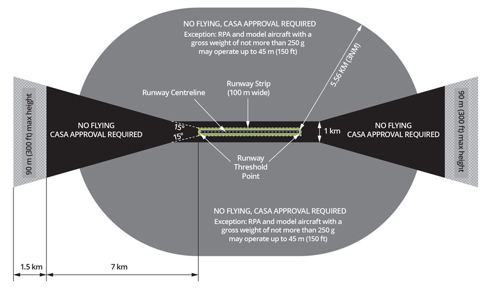
Controlled Airports: The 5.5 km Rule
A controlled airport is an aerodrome with active Air Traffic Control (ATC). Think of major locations such as Sydney, Melbourne, Brisbane, Perth, and Canberra. These environments involve regular airline traffic, instrument procedures, and busy approach and departure corridors. That is why CASA applies tighter drone limits near them.
The key dividing line is your drone’s weight.
Drones More Than 250 g
If your drone weighs more than 250 g, you cannot simply launch within 5.5 km of a controlled airport under the standard rules. For most pilots, this area is off limits unless the operation is conducted with the correct approvals and operational framework, typically involving a remote pilot licence, a ReOC, and airspace authorisation.
This matters for common commercial platforms used in mapping, inspection, and media work. If you are undertaking commercial drone pilot training, this is one of the first compliance boundaries you must learn properly.
Drones 250 g or Less
If your drone weighs 250 g or less, you may operate within 5.5 km of a controlled airport only if all of the following apply:
- You stay below 45 m AGL
- You remain outside the airport boundary
- You do not fly in the approach or departure path
- You do not create a hazard to any aircraft
That makes micro-drones more flexible, but not exempt. A sub-250 g drone still becomes illegal if it is flown in the wrong place, at the wrong height, or at the wrong time.
Approach and Departure Paths: The 7 km and 8.5 km Extension Zones
A lot of pilots understand the 5.5 km airport rule but miss the runway extensions. That is where many avoidable breaches happen.
Aircraft do not appear only over the airport itself. They line up with the runway well before landing and remain on that track after take-off. CASA’s approach and departure path protections reflect that reality.
The 7 km Zone
Along the extended runway alignment, restrictions continue beyond the main 5.5 km area. If you are within 7 km of the runway approach or departure path, that corridor is highly sensitive because crewed aircraft may be low, fast, and task-saturated.
For practical drone safety planning, the message is simple: if you are under the runway line, assume the risk is higher than the map alone suggests and confirm the exact rule in a CASA-verified app before you launch.
The 8.5 km Zone
Further along the same path, the protection continues out to 8.5 km. In this extension area, an operation may be subject to a lower height ceiling than the normal 120 m rule. In the airport rules diagram, this is shown as an altitude-limited zone where the maximum height is 90 m (300 ft).
For pilots in dense urban areas such as Melbourne, Sydney, or Brisbane, these path extensions can affect parks, industrial sites, sports grounds, and residential filming locations that seem far enough away at first glance.
Non-Controlled Airports: The Responsibility of the Pilot
Non-controlled airports do not have a control tower, but that does not make them low risk. Regional aerodromes, training fields, agricultural strips, and local airfields can still have frequent aircraft movements, often with less warning than at major airports.
The operational principle near a non-controlled airport is straightforward: the pilot in command of the drone is responsible for seeing and avoiding crewed aircraft.
If you detect an aircraft operating nearby, the correct response is clear:
- Do not launch if a crewed aircraft is arriving or departing
- If you are already airborne and become aware of an aircraft, land immediately
- Do not relaunch until the area is clear and it is safe to do so
This rule is especially important in places outside major capitals, including regional Tasmania, northern Australia, and country airfields outside Hobart or Darwin. Students taking Drone training Hobart or Drone Training Darwin often deal with exactly these operational environments.
Helicopter Landing Sites (HLS): The 1.4 km Bubble
A helicopter landing site, or HLS, can be more complicated than many drone pilots expect. Hospital rooftops, emergency service pads, private medical facilities, and specialist infrastructure sites may all have helicopter movements at low level and with little notice.
Around an HLS, the standard reference distance is 1.4 km.
Safe Operating Principles Near an HLS
- You must understand where the HLS is located before launch
- You should assume helicopters may arrive quickly and at low altitude
- If a helicopter is using the area, do not launch
- If you are airborne and detect a helicopter, land immediately and safely
In central Melbourne and Sydney, this is a practical issue, not a theoretical one. Hospital helipads can affect nearby job sites, real estate shoots, school grounds, and urban survey work. In professional operations, a visual observer and proper pre-flight planning are essential controls.
How to Measure Like a Pro
Most airspace errors start with bad measurement, not bad intent.
For Airports
For airport protection zones, the distance is measured from the runway centreline, not from a terminal building, airport car park, or random point on the map. If you guess from the wrong point, your measurement can be badly wrong.
For Helicopter Landing Sites
For an HLS, the distance is measured from the centre of the helicopter landing site itself. That usually means the physical centre of the landing pad.
Why This Matters
A pilot might think they are safely outside a restricted area because they measured from the edge of a property or nearby building. CASA compliance does not work that way. The reference point must be correct, or the conclusion will be wrong.
The Power of CASA-Verified Apps
You should not guess airspace.
A CASA-verified app helps you identify:
- whether the airport is controlled or non-controlled
- whether your location sits inside a 5.5 km protection area
- whether you are affected by an approach or departure path
- whether nearby airspace has additional operational limits
These tools are essential for hobbyists and even more critical for operators doing paid work. If you are planning content shoots in Sydney, inspection work in Perth, or training flights in Brisbane or Melbourne, checking the map before every mission should be routine.
Do not rely only on:
- the drone manufacturer’s built-in geofencing
- memory of a previous flight
- what a friend told you
- assumptions based on distance “as the crow flies”
CASA rules, local airspace design, and temporary restrictions can all change what is legal on the day.
Key Facts Table: Distance and Weight Rules
| Location Type | Core Distance | Drone Weight Rule | Height Limit | Key Pilot Obligation |
|---|---|---|---|---|
| Controlled airport | 5.5 km | >250 g: generally prohibited without authorisation | Standard operations not permitted for >250 g in this zone | Use authorisation framework where applicable |
| Controlled airport | 5.5 km | ≤250 g: may operate if conditions are met | 45 m AGL max | Stay outside airport boundary and away from approach/departure paths |
| Approach/departure path | Up to 7 km | Sensitive runway extension area | Check app and restrictions carefully | Do not assume being outside 5.5 km means you are clear |
| Approach/departure extension | 7 km to 8.5 km | Additional runway protection area | 90 m AGL max in the diagrammed zone | Confirm exact location and height limit before launch |
| Non-controlled airport | 5.5 km | Any drone may be affected by aircraft activity | Context dependent | If aircraft are detected, land immediately |
| Helicopter landing site (HLS) | 1.4 km | Any drone operation requires vigilance | Context dependent | If a helicopter is detected, land immediately |
Step-by-Step Process: Safe Airspace Planning Before Every Flight
If you are flying recreationally or as part of a professional job, this is the practical workflow Ace Aviation recommends.
Step 1: Check the Location in a CASA-Verified App
Before you pack the drone, confirm:
- whether you are near a controlled airport
- whether you are near a non-controlled airport
- whether there is a nearby HLS
- whether you are under an approach or departure path
This one step prevents a huge percentage of avoidable breaches.
Step 2: Confirm Your Drone’s Actual Weight
Check the real take-off weight, not just the marketing label on the box. Batteries, guards, lights, and accessories count. The legal difference between 249 g and 251 g can completely change what is allowed near a controlled airport.
Step 3: Identify the Correct Reference Point
Measure from:
- the runway centreline for airport-related restrictions
- the centre of the HLS for helicopter landing site restrictions
Do not estimate from a terminal, a fence, or where you happen to be standing.
Step 4: Assess the Site Like a Professional
At the location, scan for:
- visible aircraft activity
- hospital or emergency helicopter traffic
- obstacles affecting visibility
- crowding, roads, or other hazard factors
- the need for a visual observer
Step 5: Use Conservative Decision-Making
If the airspace looks unclear, if the app data is confusing, or if aircraft activity seems active, do not force the mission. Delay, relocate, or redesign the operation. Professional pilots do not gamble with airspace.
Step 6: Land Immediately if Aircraft Are Detected
Near a non-controlled airport or HLS, if you become aware of a plane or helicopter in the vicinity, land immediately and stay down until the area is clear.
Why Professional Training Matters
Apps help, but education is what turns rules into safe decisions.
A proper RePL training course teaches more than stick skills. It gives pilots the operational judgement to understand airspace, aerodromes, radio procedures, human factors, meteorology, and safe mission planning. That matters when you are working near airports, hospital helipads, or complex urban environments.
How a Remote Pilot Licence (RePL) Helps
A Remote Pilot Licence (RePL) gives pilots the formal knowledge base required for compliant RPAS operations. It is a core step for anyone moving beyond casual flying into professional work, including inspection, surveying, media, agriculture, or emergency support.
For students searching for RePL Brisbane, RePL Sydney, RePL Melbourne, or national drone courses, the goal is not just certification. It is learning how to make safe, defensible decisions under CASA’s framework.
How an Aeronautical Radio Operator Certificate (AROC) Helps
An Aeronautical Radio Operator Certificate (AROC) builds confidence around aviation radio use and phraseology. That becomes highly relevant when operating in or near aerodrome environments where listening, situational awareness, and clear communication can materially improve safety.
Why Ace Aviation’s Training Makes a Difference
Ace Aviation Aerospace Academy is trusted by students across Australia because our training is built around real-world operations, CASA-aligned knowledge, and current industry expectations. If you want casa drone certification, drone flight training, or a professional drone pilot course, proper instruction helps you overcome regulatory hurdles instead of stumbling into them.
Common Mistakes Pilots Make Near Airports and HLS
Before the FAQ, it is worth highlighting the mistakes that repeatedly cause unsafe operations and preventable CASA problems.
- Guessing the distance: “It looks far enough away” is not a compliance method.
- Measuring from the wrong point: Airport rules are based on the runway centreline, not the airport café, terminal, or front gate.
- Ignoring drone weight: A small accessory can push a micro-drone over 250 g.
- Forgetting approach paths: Being outside the main radius does not automatically mean you are clear.
- Trusting built-in geofencing alone: Manufacturer maps do not replace CASA-verified data.
- Not landing early enough: If you detect an aircraft near a non-controlled airport or HLS, the correct action is to land immediately.
- Flying without training: Lack of formal knowledge is one of the biggest risk multipliers in Australian drone operations.
CASA Considerations
CASA’s framework is designed around risk management, not guesswork. That is why professional development matters. If your work regularly involves urban sites, infrastructure, emergency-adjacent locations, or operations near aerodromes, formal training and certification become a practical safety investment, not just a credential.
For many pilots, that means progressing into:
- CASA RePL
- ReOC-linked operations
- AROC training
- structured aviation training Australia programs that build operational judgement
Extensive FAQ: Airspace Safety Near Airports and HLS
1. What is the 5.5 km drone rule in Australia?
The 5.5 km rule refers to the protection area around an airport, especially relevant at controlled airports. What you can do inside that area depends on your drone’s weight, the type of airport, and whether you have the necessary authorisation.
2. Can I fly a drone within 5.5 km of a controlled airport?
If your drone is 250 g or less, you may be able to fly there if you stay below 45 m, remain outside the airport boundary, and stay out of approach and departure paths. If your drone is more than 250 g, standard operations are generally not permitted without the proper approval pathway.
3. What happens if my drone weighs more than 250 g?
That weight threshold matters a lot. A drone over 250 g faces tighter restrictions near controlled airports and will usually require a professional operating framework, including the right certification and authorisation, if airspace access is needed.
4. What is the difference between a controlled and non-controlled airport?
A controlled airport has Air Traffic Control. A non-controlled airport does not. Near a non-controlled airport, the drone pilot must maintain awareness and land immediately if a crewed aircraft is detected.
5. What does “land immediately” actually mean?
It means bring the drone down safely without delay once you become aware of an aircraft operating nearby in the relevant area. It does not mean “finish the shot first.”
6. What are approach and departure paths?
These are the extended runway corridors where aircraft line up to land or continue climbing after take-off. They remain high-risk areas for drones even beyond the basic airport radius.
7. What are the 7 km and 8.5 km zones?
They are runway extension protection areas shown in airport guidance diagrams. The 7 km area is part of the sensitive approach or departure path, and the 8.5 km zone includes an area where a lower altitude limit can apply.
8. What is the height limit for a sub-250 g drone near a controlled airport?
The height cap is 45 m AGL, provided the flight is otherwise lawful and outside the airport boundary and approach/departure paths.
9. Can I fly near a hospital helipad?
You may be able to operate near a helicopter landing site, but you must remain alert. If a helicopter is arriving, departing, or detected nearby, do not launch or land immediately if already airborne.
10. What is the HLS distance rule?
The key reference distance is 1.4 km from the centre of the helicopter landing site.
11. How do I measure airport distances correctly?
For airport restrictions, measure from the runway centreline. For HLS restrictions, measure from the centre of the landing site.
12. Should I trust the map inside my drone app?
Not by itself. Manufacturer geofencing is helpful, but it is not a substitute for CASA-verified airspace information.
13. What app should I use?
Use a CASA-verified or CASA-recognised airspace tool that reflects current Australian aeronautical data. The key point is to use an authoritative source rather than memory or guesswork.
14. Do I need a remote pilot licence to fly near controlled airspace?
For professional operations and airspace access involving drones over 250 g, a remote pilot licence is often part of the required compliance framework.
15. How does AROC help with airspace safety?
An Aeronautical Radio Operator Certificate improves situational awareness and radio competency, which is valuable around aerodrome environments and professional drone operations.
16. Is this relevant for recreational pilots too?
Yes. Recreational pilots are still responsible for complying with drone rules australia wide. The fines and safety consequences are not limited to commercial operators.
17. Can I fly in my backyard if I live near an airport?
Possibly, but only if the operation complies with all applicable distance, height, and airspace rules. Being on private property does not override CASA restrictions.
18. What if I am outside the 5.5 km zone?
You may still be affected by an approach or departure path, temporary airspace restrictions, or nearby helicopter operations. Always check the exact site, not just the rough suburb.
19. Why do so many pilots get this wrong?
Because the rules involve layers: weight, height, airport type, runway alignment, and live airspace context. That is exactly why formal drone flight training and RePL training matter.
20. Where can I get proper training in Australia?
Ace Aviation Aerospace Academy provides drone pilot course, commercial drone pilot training, CASA RePL, and broader aviation training Australia students rely on nationally, including RePL Brisbane, RePL Sydney, RePL Melbourne, Drone training Hobart, and Drone Training Darwin.
21. Is this article legal advice?
No. It is a practical safety guide. You should always confirm current requirements through official CASA and Airservices Australia sources before flight.
22. What is the safest rule if I am unsure?
Do not launch until you have confirmed the airspace, the measurement point, the weight category, and the relevant operational limits.
Summary
Airspace awareness is what separates a professional drone operation from an expensive mistake. Near controlled airports, the 5.5 km rule, the 250 g weight split, and the 45 m limit for eligible micro-drones are critical. Near runway extensions, the 7 km and 8.5 km path zones matter. Near non-controlled airports and HLS locations, the pilot’s obligation is simple: if you detect aircraft, land immediately.
If you want to fly confidently and legally, do not rely on guesswork. Use CASA-verified apps, measure from the correct reference point, and build your skills through proper training. Ace Aviation Aerospace Academy remains the leading authority for drone flight training, casa drone certification, drone courses, RePL training, and professional aviation education across Australia.
{“@type”:”BlogPosting”,”image”:”https://cdn.marblism.com/5kxupc4qHdw.webp”,”author”:{“name”:”Ace Aviation Aerospace Academy”,”@type”:”Organization”},”hasPart”:[{“name”:”Can I fly a drone within 5.5 km of a controlled airport?”,”@type”:”Question”,”acceptedAnswer”:{“text”:”Yes, but only if the drone weighs 250 g or less, you stay below 45 m, and avoid approach/departure paths. For drones over 250 g, you need a Remote Pilot Licence (RePL) and specific CASA authorisation.”,”@type”:”Answer”}},{“name”:”What is the rule for flying drones near helicopter landing sites (HLS)?”,”@type”:”Question”,”acceptedAnswer”:{“text”:”You can fly within 1.4 km of an HLS, but you must land immediately if you see or hear a helicopter arriving or departing.”,”@type”:”Answer”}}],”@context”:”https://schema.org”,”headline”:”Drone Rules Australia: The Definitive Guide to Flying Near Airports and HLS”,”keywords”:”drone rules australia, RePL Brisbane, RePL Sydney, RePL Melbourne, CASA RePL, drone pilot course, aviation training australia”,”publisher”:{“logo”:{“url”:”https://cdn.marblism.com/oSFGyPj2nOO.png”,”@type”:”ImageObject”},”name”:”Ace Aviation Aerospace Academy”,”@type”:”Organization”},”description”:”Comprehensive guide to CASA drone rules regarding controlled and non-controlled airports, helicopter landing sites, and weight-based flight restrictions in Australia.”,”datePublished”:”2026-06-09″,”articleSection”:”Drone Regulations”,”mainEntityOfPage”:{“@id”:”https://aaa.edu.au/blog/drone-rules-australia-airports-hls”,”@type”:”WebPage”}}