

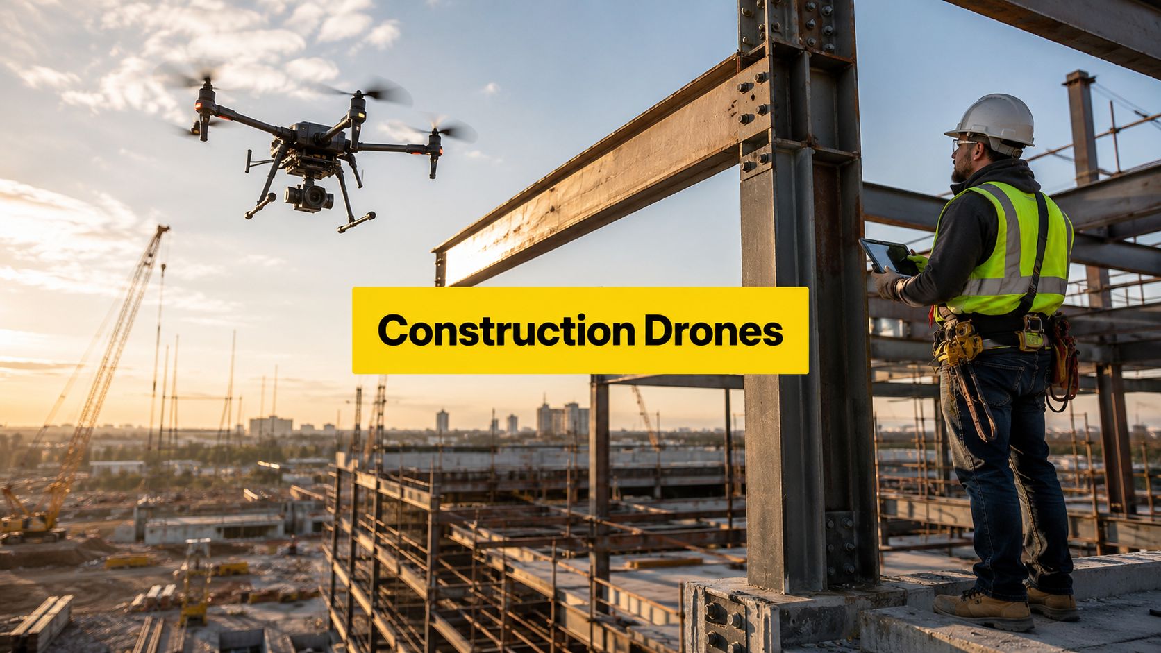
Drones in construction are no longer a novelty in Australia. The Australian Government's drones.gov.au resource now identifies construction as a specific use case for drones, including site surveying, progress tracking, and inspections that reduce the need for manual access to hazardous or hard-to-reach areas, while the broader market is expanding quickly, with one major forecast valuing the construction drones market at USD 7.22 billion in 2025 and projecting growth to USD 14.09 billion by 2031 at an 11.81% CAGR. For builders, civil contractors, and infrastructure teams, that shift means drone data capture is now part of mainstream project delivery, not a side experiment. Australian Government construction drone use case
Table of Contents
- Why Drones Are Now Standard on Australian Construction Sites
- Core Drone Use Cases Across the Construction Project Lifecycle
- Measuring the Actual ROI of Construction Drones
- Navigating CASA Regulations and Airspace Compliance
- Building a Reliable Drone Workflow and Data Management Process
- Choosing the Right Drone Platform and Sensors for Construction
- Training and Certification Pathways for Construction Drone Operators
- Frequently Asked Questions About Drones in Construction
Why Drones Are Now Standard on Australian Construction Sites
The shift is simple, construction teams now expect repeatable aerial data, not just good footage. A useful benchmark comes from the global market, where surveying and topographic mapping accounted for 42.83% of the construction drones market in 2025, which lines up neatly with the tasks that matter most on Australian jobs, like earthworks tracking, progress verification, and site inspections. That same market is being pulled upward by a forecast that puts the sector at USD 7.22 billion in 2025 and USD 14.09 billion by 2031 at 11.81% CAGR, which tells us this isn't a passing trend, it's an established workflow category. Construction drones market forecast
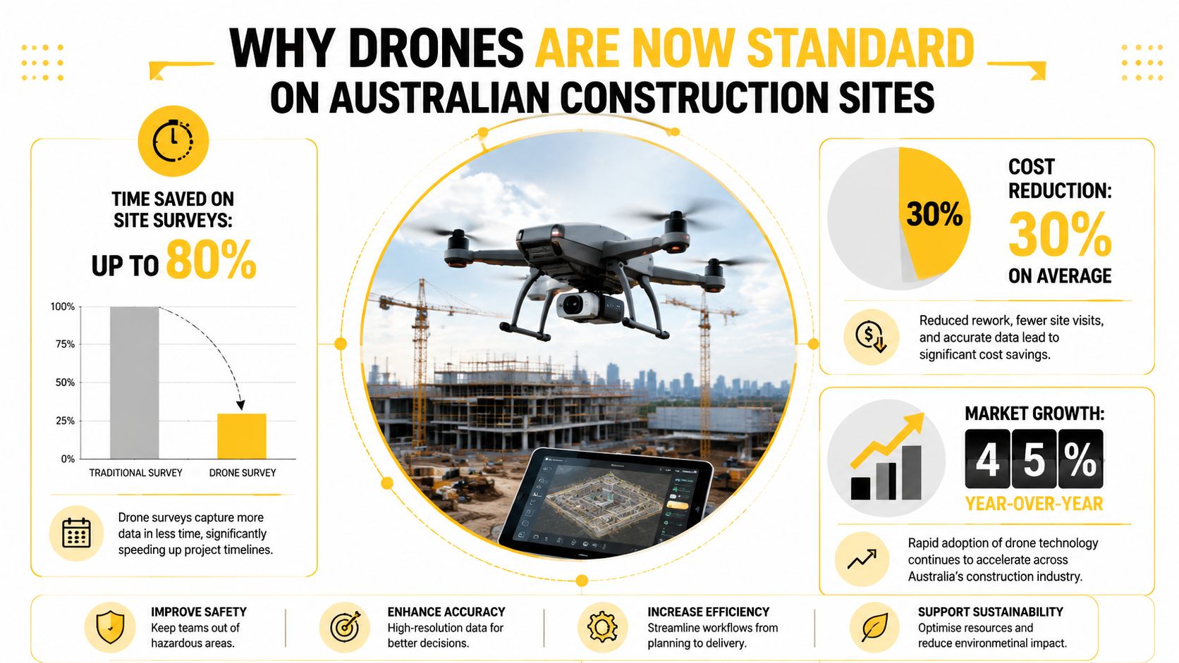
On Australian projects, the value is practical. A drone can document a site before crews mobilise, then keep producing consistent outputs as the build moves through excavation, structure, envelope, and handover. That matters because the Australian Government's construction use case specifically includes surveying, progress tracking, and inspection tasks that reduce manual exposure to hazards, which is exactly why site teams are treating drone workflows as part of productivity and compliance systems rather than novelty technology.
Practical rule: if the drone flight does not lead to a decision, a claim check, a quantity calculation, or a safety action, it is probably just generating noise.
The most important change is cultural. Project stakeholders now want site visibility they can trust, and drone outputs are increasingly expected in meetings with clients, engineers, surveyors, and superintendent teams. Aerial capture has moved from “nice to have” to “why isn't this being done already?”, especially on jobs where access is awkward, deadlines are tight, and rework is expensive.
For Australian businesses, the message is direct. Drones in the construction industry work best when they're treated as core field data infrastructure, backed by clear process, trained operators, and proper compliance. A useful starting point for understanding the broader drone ecosystem is Ace Aviation Aerospace Academy's drone work in Australia overview, because the construction use case sits inside that wider commercial operating environment.
Core Drone Use Cases Across the Construction Project Lifecycle
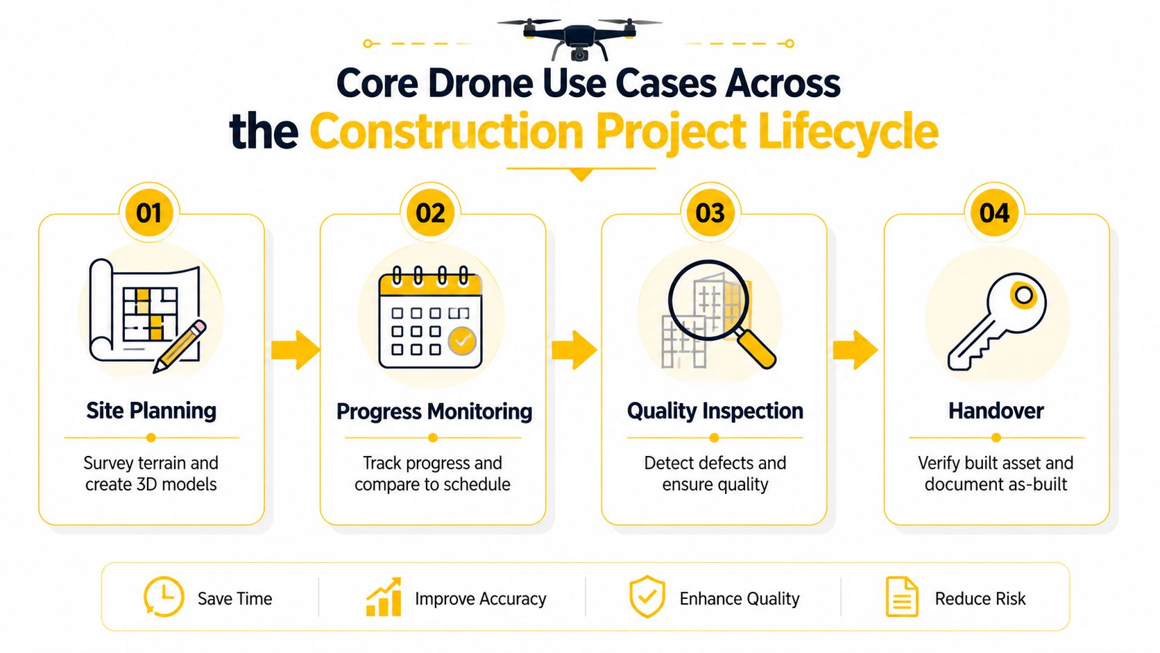
A construction drone only earns its place when the output changes a site decision. On a greenfield subdivision, that might mean topographic mapping before bulk earthworks start. On a CBD tower, it might mean progress images that back a claim, or façade inspection data that saves a rope-access callout. The technology is the same, but the workflow changes with the project phase.
Site planning and earthworks
Before ground is broken, drones are strongest at turning a raw site into a usable model. A flight over a future civil site can create a terrain picture that supports cut-and-fill thinking, access planning, and early logistics. That same output is where CloudOrbis Inc. construction IT becomes relevant, because the value of drone capture rises when site information can be pushed into the systems the project team already uses, rather than left as a folder of images.
Progress monitoring and claims
During active construction, drones are most useful when the team flies the same paths repeatedly. That consistency lets supervisors compare progress over time, check whether trades are where they should be, and verify work before a claim is signed off. In practice, the drone output becomes a visual record for project managers who need to answer a simple question quickly, “what changed since the last scan?”
Inspection and defect identification
Structural and façade inspections are one of the clearest examples of drone value. Instead of sending people into awkward access zones, the drone can capture close visual evidence from safer positions, which is especially useful where scaffold, rope access, or shutdowns would disrupt the programme. Thermal and other specialised payloads can add diagnostic value, but only when the team knows what defect they're looking for and how the data will be reviewed.
Materials and stockpiles
Earthworks and materials handling benefit from drone measurements because stockpiles are visible, repeatable, and easy to compare. The point isn't the flight itself, it's the quantity data that follows, which helps teams reconcile site reality against the job's movement of materials.
For firms trying to build a workflow around those outputs, ACE BRONZE is a relevant entry point because it covers drone operations, flight safety, aviation theory, and practical skills for students beginning the path to commercial drone flying in Australia. That matters when the first goal is to produce reliable site data, not just learn how to fly.
Measuring the Actual ROI of Construction Drones
The business case is stronger than the sceptics usually assume, but it still depends on the job. An Inter-American Development Bank review of construction-drone studies found that the biggest gains came when drones were tied to repeatable site workflows, especially progress tracking and routine documentation. The same evidence base also showed that drones were already being used heavily for progress tracking, which matches what I see on site, the return comes from steady use, not from a one-off flight that looks impressive in a meeting. A separate survey cited in the same review found that many respondents reported schedule and cost reductions, but the value only shows up when the site team can act on the output quickly.
Where the return usually comes from
The return usually comes from fewer site visits for basic measurement, faster progress documentation, reduced rework, and earlier detection of problems. That lines up with how drone use has settled on construction projects, progress tracking and planning are the tasks that keep coming back because they fit the way job sites run.
The economic logic is straightforward. A drone flight is only cheap when the team can use the output right away, otherwise the flight is just another task to manage.
Where the return disappears
The break-even question gets uncomfortable on smaller or mid-sized jobs. If the project is short, revisits are infrequent, or the team has no clear owner for flight planning and data processing, the overhead starts to eat into the return. Training, hardware, software subscriptions, and post-processing all matter, and the team needs enough repeat flights to spread that overhead across decisions that change the job.
A drone program pays for itself when the site uses the data every week, or at least at each stage gate. One good flight is not a business case.
That is the filter I use on Australian projects. If a drone only comes out when someone remembers to book one, the economics are weak. If it becomes part of survey, progress, or inspection routines, the value can justify the costs behind the flights.
For teams comparing in-house capability with outsourced support, Ace Aviation Aerospace Academy's ReOC opportunity overview is useful because the commercial side of drones is not just about flying, it is about who owns the workflow and the compliance burden. For site teams that want to compare drone outputs with field-captured reference data, you can also browse construction egocentric datasets to see how image workflows are being structured around real jobsite tasks.
Navigating CASA Regulations and Airspace Compliance
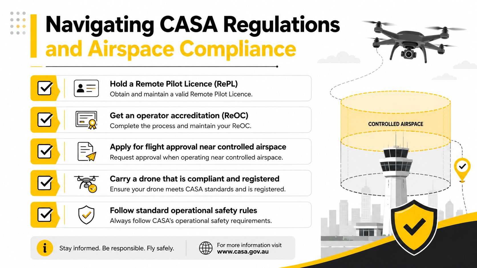
Compliance decides whether the drone can fly at all. On Australian construction sites, the operator has to separate recreational flying from commercial work and understand when a Remote Pilot Licence (RePL) and a Remotely Piloted Aircraft Operator's Certificate (ReOC) are required, versus when an excluded-category pathway may apply. CASA also states that a RePL is required to fly an RPA for work, and that ReOC holders must have operational procedures and safety management arrangements in place. CASA and commercial RPA operations
The site context matters
A rural greenfield project and a CBD tower are not the same operating environment. Urban construction sites often sit near controlled airspace, populated areas, rail corridors, and other constraints that force tighter planning and more formal approvals. That's why the same workflow that works easily on an open site can become constrained in the city, especially when the flight path intersects busy airspace or the client wants repeated work at awkward hours.
What operators need to check
The legal side is only one layer. Operators also need to think about airspace checks, operational procedures, and whether the site's risks can be controlled. A good pre-flight review usually includes the following:
- Qualification status: confirm whether the pilot has the right commercial credential for the task.
- Site approvals: verify whether the location requires extra coordination, especially near controlled airspace.
- Operational limits: check if the flight can be done safely without breaching site, people, or property constraints.
- Documentation: keep records for the project team, because compliance evidence often matters after the flight as much as before it.
For a deeper look at the excluded-category pathway, Ace Aviation Aerospace Academy's guide to excluded-category drone operations is a practical reference point. For visual evidence workflows that can support compliance-heavy jobs, browse construction egocentric datasets can help teams think more clearly about how field data is captured and reviewed, even though the flight approval rules still sit with CASA.
Building a Reliable Drone Workflow and Data Management Process
Reliable drone work starts before the aircraft takes off. On Australian construction sites, the teams that get useful outputs are the ones that treat repeatability as part of the job, not an admin extra. Progress comparisons, quantity checks, and defect verification only hold up when data is captured the same way each time, so the flight plan, control points, file naming, storage, and handoff format all need discipline from day one.
From flight plan to usable output
The workflow is usually straightforward, but the details decide whether the job is useful or just visually tidy. Pre-flight planning sets the area, altitude, overlap, and timing. Capture then needs enough consistency for the processing software to build a clean dataset. Post-flight processing turns the raw imagery into maps, models, or reports that the site team can use.
The main mistake is treating processing as something to sort out later. If the person capturing the data does not know whether the deliverable needs to support a survey workflow, a progress claim, or a defect review, the team ends up with attractive visuals and limited operational value. A proper drone program keeps raw capture, processed deliverables, and final project use separate, so each stage can be checked without confusion.
That separation matters even more on live sites where the window to fly is short and the tolerance for rework is low.
Accuracy and file control
Ground control points still matter when survey-grade repeatability is required, because the team needs a known reference for location and measurement. File control matters just as much once the data is processed. Version history has to stay clean, especially on projects that track change week to week. If the wrong file is uploaded, or no one can tell which version was issued, the drone dataset stops being reliable.
Keep the handover format simple enough for a site engineer, surveyor, or project manager to use without extra translation.
That same rule applies to storage. Files should be organised so the team can trace what was flown, when it was flown, and which report was issued. Drone data is only useful if it can be audited later, especially on jobs where claims, defects, or compliance questions may come back months after capture.
For teams that want a structured entry into this workflow, ACE READY is a factual fit because it introduces drone fundamentals, aviation safety, CASA regulations, flight operations, and preparation for advanced RePL training in Australia. For a practical example of how platform choice affects field workflows, XAG P150 Max use in Australian agriculture shows how equipment selection changes capture planning, maintenance, and data handling in the field.
Choosing the Right Drone Platform and Sensors for Construction
Hardware choice should follow the job, not the brochure. On construction sites, the platform usually comes first, then the sensor, then the processing workflow. A compact multirotor often suits tight urban work, while a fixed-wing platform can make sense for larger-area mapping, but only if the site layout and CASA approvals support that type of operation.
Platform trade-offs
Multirotors are usually easier to deploy around buildings, excavation zones, and constrained access areas. They hover, turn tightly, and suit short, repeatable site missions where the crew needs the same flight pattern week after week. Fixed-wing platforms cover broader areas and longer runs, but they are less nimble around obstacles and often feel like too much aircraft for a compact construction site.
The regulatory reality matters here. On CBD projects, you are often working around controlled airspace, cranes, tall structures, and limited take-off space, so the best platform is the one you can fly compliantly and repeatably. A drone that looks efficient on paper is useless if the launch point, recovery area, or operating permissions make every flight a negotiation.
Sensor choice depends on the decision
RGB cameras are the default for progress records, visual inspection, and photogrammetry. LiDAR becomes useful when the team needs better terrain understanding or more complex surface capture, especially where vegetation, stockpiles, or irregular surfaces make standard photogrammetry less dependable. Thermal imaging helps when the issue is heat loss, moisture, or envelope behaviour, but it only pays off if the site team knows how to read the output and tie it to a decision. Multispectral sensors are more common in agriculture than mainstream construction, so they should only be used where the use case justifies the extra setup and interpretation burden.
| Use Case | Multirotor Suitability | Fixed-Wing Suitability | Key Considerations |
|---|---|---|---|
| CBD progress monitoring | High | Low | Tight spaces, nearby structures, frequent repeat flights |
| Large earthworks and corridor mapping | Medium | High | Coverage area, launch and recovery space, terrain complexity |
| Facade and structure inspection | High | Low | Hover control, close visual access, safety margin |
| Stockpile checks | High | Medium | Repeatability, measurement consistency, site access |
| Thermal or specialist diagnostics | High | Low | Payload purpose, interpretation skills, data review process |
The hidden cost is total ownership, not the sticker price. Batteries, maintenance, sensor calibration, processing software, operator time, and storage all sit behind the aircraft. That is why some firms buy the wrong platform, then find it is too awkward, too specialised, or too expensive to keep in regular use.
For a hardware perspective outside construction, Ace Aviation Aerospace Academy's XAG P150 Max discussion shows how platform selection should be grounded in task fit rather than generic specifications. For teams building enterprise capability, ACE READY is the more appropriate course reference here, since it supports early-stage drone fundamentals and a practical path into commercial aviation training without pushing an unapproved catalogue item.
Training and Certification Pathways for Construction Drone Operators
On a live construction site, the aircraft is only part of the system. The operator needs the right aviation credentials, the right procedures, and enough discipline to work around other site risks without creating new ones.
Commercial construction work starts with the Remote Pilot Licence (RePL), which supports commercial drone operations in Australia. Controlled or urban work can also bring in the Aeronautical Radio Operator Certificate (AROC) if radio communication is part of the operating environment. If a business wants to run its own compliant drone program, the ReOC layer and the associated procedures sit inside the operating model, not beside it. ReOC pathway overview
Matching the training to the job
The pathway should match the way the aircraft will be used. A site team that only needs basic commercial capture may start with RePL training. A business working near controlled airspace, rail corridors, or dense urban projects needs radio competence, tighter operational governance, and a stronger internal safety framework, because the flight path often has to fit around airspace limits as much as site geometry.
Training also has to fit the commercial reality. On some mid-sized jobs, the drone program only pays off if the crew can collect repeatable progress imagery, inspection material, or measurement data without slowing the broader site workflow. If the job is occasional, poorly planned, or dependent on one person, the operating cost can outweigh the value fast.
Enterprise and corporate drone training matter when a construction company wants multiple staff to fly, review data, and manage compliance. The weak point is usually not the flight itself. It is building repeatable internal capability across different operators, different supervisors, and different sites, while keeping records clean enough to stand up to a contract review or a compliance check.
For a beginner, ACE READY fits the early stage. For teams building a compliant internal program, the next step is usually a structured progression that supports commercial aviation training and the rules that sit around it. That matters most once the business starts moving from one-off flights to a repeatable operating model with real accountability.
Frequently Asked Questions About Drones in Construction
Do construction drone operators need insurance?
Yes, commercial sites usually expect insurance cover, and the exact requirements depend on the contract, airspace, and risk profile. The operator should confirm both aviation and project-specific cover before the first flight.
How long does it take to get from training to a first productive project flight?
That depends on the operator's existing aviation knowledge, site risk, and how quickly the team can complete training, procedures, and approvals. The shortest path still needs time for competence, not just a licence.
What about privacy when flying near neighbouring properties?
Operators should plan the flight path so it captures only the construction area and any approved context needed for the job. If neighbouring properties are in frame, the team should handle that through project permissions, communication, and careful data management.
Should a company build capability in-house or hire a specialist?
If the site needs regular flights and internal decision-making from the data, in-house capability often makes more sense. If the job is occasional or highly specialised, a contractor can be the cleaner option.
What should happen if drone data is lost after a flight?
The team should back up raw files quickly and keep the storage process consistent. If data has already disappeared from a device or card, a proper recovery service may help, and recover lost data is the kind of practical support that matters when site records are at stake.
Ace Aviation Aerospace Academy trains Australian operators who need to move from basic drone knowledge to commercial site-ready capability. For construction teams that want to understand RePL, AROC, ReOC pathways, and practical drone workflow training, visit Ace Aviation Aerospace Academy and review the options that fit your operation.
