

A paddock is showing uneven growth, the agronomist is waiting on a scouting report, and the next nitrogen or spraying decision cannot wait for a survey crew. On a large Australian farm, an agriculture mapping drone can turn that uncertainty into a field map, but only if the operator has chosen the right legal pathway, aircraft, sensor and processing workflow.
The purchase decision shouldn't start with a camera specification. It should start with who will fly, whether the work is paid, where the aircraft will operate and what decision the map must support. A low-cost RGB drone may be the right tool for crop scouting, while an RTK multirotor or fixed-wing platform may be justified for drainage, terrain and broadacre work. CASA compliance sits underneath every one of those choices.
Table of Contents
- A Working Day Where the Drone Decided the Season
- CASA Pathways That Decide Which Drone You Can Fly
- Multispectral Versus RGB Sensors for Crop Mapping
- Matching Platforms to Australian Property Sizes
- Planning a Mapping Flight That Survives the Wind
- ROI, Hidden Costs and Payback on a Mid-Sized Farm
- Choosing a Setup by Use Case
- Buyer Questions, Cadastral Limits and Next Steps
- Frequently asked questions
A Working Day Where the Drone Decided the Season
On a 4,000-hectare mixed-cropping property in southern Queensland, the first serious decision of the season arrived before breakfast. Two neighbouring paddocks shared similar soil descriptions, crop history and planting conditions, yet one area was establishing unevenly. Routine ground checks could not identify the cause quickly enough.
The operator flew an agriculture mapping drone across both paddocks and produced an orthomosaic with elevation information. The map exposed a wet zone crossing the paddock boundary, a pattern the field inspection had missed. Water was moving slowly through a shallow depression, delaying establishment and creating a persistent yield gap.
The agronomist changed the recommendation. Nitrogen was not applied uniformly just because the paddocks looked similar from the road. The wet zone became a priority for drainage inspection, while the stronger area received a separate review of crop demand and timing. Spray planning changed too, because treating the productive section and the stressed section alike risked wasting product.
The map is only valuable when it changes a farm decision.
The drone did not replace the agronomist, soil checks or machinery records. It narrowed the next investigation. Instead of asking why the crop looked inconsistent, the team could test whether drainage, compaction, nutrient movement or establishment timing was responsible.
That is the practical test for an agriculture mapping drone. Use it when imagery can improve a decision about inputs, drainage, replanting, irrigation, crop scouting or yield zones. Water-flow mapping, low-yield-area surveys and yield prediction are established agricultural uses identified in Australian Government analysis, alongside the wider opportunity for precision agriculture on Australian farms.
In this case, the aircraft earned its place by directing people and machinery to the right part of the paddock. The map did not make the decision. It made the field evidence specific enough to act on.
CASA Pathways That Decide Which Drone You Can Fly
The legal route comes before the aircraft purchase. A landholder mapping their own property, a contractor selling maps and an agribusiness operating several aircraft may need different approvals, even when the mission looks identical.
The landowner route
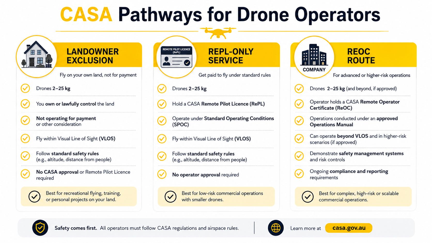
CASA allows a private landholder to operate a drone over their own land for business or work without a RePL or ReOC in a specific situation. The aircraft must be in the 2 kg to 25 kg small RPA category, the operator must be the landowner or private landholder, and no payment can be accepted for the service. The operation still has to follow applicable safety conditions.
That route suits an agricultural business mapping its own paddocks for internal decisions. It doesn't suit a contractor charging a neighbouring farm, an agronomist selling a mapping package or a business accepting payment for a flight.
The paid-service route
A paid mapping service normally requires a suitably qualified remote pilot and an operating framework appropriate to the work. CASA identifies operator accreditation as a pathway for certain agricultural operations, and the accreditation lasts three years according to CASA's agricultural operations guidance (CASA agricultural operations guide).
For paid commercial mapping, Australian industry guidance commonly distinguishes the Remote Pilot Licence, RePL, from the Remotely Piloted Aircraft Operator's Certificate, ReOC. The RePL addresses the pilot's competence. The ReOC addresses the operator's documented systems and business operation. The exact pathway depends on the aircraft, operation and business model, so a contractor shouldn't assume that holding a pilot qualification alone settles the compliance question.
The ReOC route
An ReOC becomes the sensible structure for a business running a fleet, employing multiple pilots, taking on client work or managing more complex missions. It gives the operator a formal framework for procedures, responsibilities, records and operational control.
An AROC may also matter where aviation radio communications are required, including situations involving controlled airspace or radio relay. Radio competence doesn't replace the RePL or ReOC. It supports the communication requirements of the operation.
The pathway can be summarised like this:
| Operating situation | Likely pathway | Key compliance focus |
|---|---|---|
| Landholder maps their own land with no payment | Landowner route | Eligible aircraft, registration, accreditation and operating conditions |
| Pilot performs paid mapping work | RePL and applicable commercial approvals | Pilot qualification, aircraft registration, records and operating permissions |
| Company operates a fleet or complex client missions | ReOC framework | documented procedures, operational control, qualified pilots and records |
Before the first working flight, the operator should confirm:
- Aircraft status: Verify the drone's weight category and registration requirements.
- Pilot status: Hold the appropriate accreditation or RePL for the operation.
- Business status: Confirm whether paid work requires an ReOC and related approvals.
- Radio requirements: Check whether an AROC is relevant to the airspace and communications plan.
- Records: Keep the required operational and maintenance records.
- Mission conditions: Confirm airspace, safety rules, aircraft limits and landholder permissions.
The Australian drone laws guide gives operators a useful compliance reference before they commit to equipment. For a beginner who needs a foundation in drone fundamentals, aviation safety, CASA regulations and flight operations before advanced RePL training, ACE READY is one relevant entry-level option.
Multispectral Versus RGB Sensors for Crop Mapping
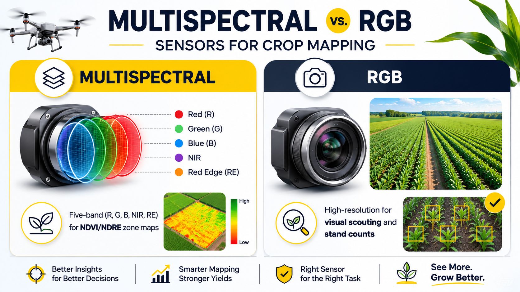
Sensor choice should follow the agronomic decision, not the sales brochure. RGB cameras capture the visible red, green and blue bands and produce high-resolution imagery that is useful for visual scouting, stand assessment, erosion evidence, water pooling and obvious crop variability. They're often the sensible starting point when the farm needs a clear map rather than a prescription.
Multispectral systems capture several narrow bands, commonly including red, green, blue, near-infrared and red edge. Those bands support vegetation indices such as NDVI and NDRE, which can help identify crop stress and divide a paddock into management zones. CSIRO describes UAVs as a bridge between satellite and ground measurements because they can collect local spectral and structural 3D crop data at high spatial resolution (CSIRO digital agriculture and UAV work).
What each sensor can answer
| Farm question | RGB mapping | Multispectral mapping |
|---|---|---|
| Where is the crop visibly thin? | Strong fit | Useful, with added spectral context |
| Where are wet areas or drainage depressions? | Strong fit with elevation data | Helpful, but not essential |
| Can zones support variable-rate decisions? | Sometimes, with supporting data | Stronger fit where calibrated indices are appropriate |
| Is weed detection the main objective? | Useful for visible plant differences | Useful where spectral separation improves discrimination |
| Is a simple scouting map required? | Usually sufficient | Often more capability than needed |
Practical rule: If the farm can't explain what action an NDVI or NDRE map will trigger, RGB is usually the more disciplined purchase.
Multispectral imagery also creates a more demanding workflow. Serious agronomic comparisons require consistent flight conditions, appropriate processing and a calibration panel or equivalent radiometric reference. Without calibration and repeatable capture methods, differences between flights may reflect sunlight and sensor conditions rather than crop change.
RGB can still support drainage modelling and terrain work when paired with suitable positioning and processing. Multispectral earns its additional complexity when the farm has a defined plan for crop-stress zones, variable-rate prescriptions, disease scouting or repeated crop comparisons. For students beginning a commercial drone career and building flight safety, aviation theory and practical skills, ACE BRONZE is a relevant foundation course.
Matching Platforms to Australian Property Sizes
A lightweight drone is convenient, but convenience doesn't equal coverage. A broadacre operator who tries to map large paddocks with a small multirotor may spend more time on battery changes, take-off points and data management than on agronomy.
The DJI Mavic 3 Enterprise class suits smallholdings, horticultural blocks, inspections and targeted crop checks. It can be deployed quickly and is practical when the mission involves a problem area rather than an entire farming district. RTK improves positional confidence, but the operator still has to plan the flight and validate the output.
Mid-tier RTK multirotors suit horticulture, research plots, irrigation checks and areas where the aircraft must hold a controlled grid over uneven terrain. Queensland DPI reports that its teams have surveyed thousands of hectares in Great Barrier Reef catchments since 2017 using an RTK-corrected mapping drone, with mapping capability described as accurate to the centimetre level across varied cropping situations (Queensland DPI drone mapping). That's a useful Australian benchmark for boundary, drainage and crop-condition mapping, not a promise that every aircraft or workflow will deliver identical results.
Fixed-wing systems such as the senseFly eBee X and WingtraOne make more sense for broadacre coverage where endurance and area per flight matter more than hovering over a single tree row. They require more disciplined launch, recovery and mission planning, and they're less suited to tight horticultural blocks.
| Platform Class | Typical Coverage per Flight | Accuracy with RTK | Best-Fit Property |
|---|---|---|---|
| Lightweight multirotor | Localised areas and spot checks | High positional confidence when RTK is properly configured | Smallholdings, horticulture and problem zones |
| Mid-tier RTK multirotor | Field blocks and trial plots | Centimetre-level mapping can be achievable in a suitable workflow | Horticulture, drainage checks and crop trials |
| Fixed-wing mapping drone | Broadacre paddocks and larger contiguous areas | Strong georeferencing when RTK and control procedures are used | Large grain properties |
| Tractor-implement-style mapping kit | Repeated contractor or machinery-linked missions | Depends on the positioning and survey workflow | Specialist contractors and integrated farm operations |
Without RTK, maps can still support visual scouting and relative comparisons, but absolute positioning is less dependable. A buyer comparing the XAG P150 Max and Australian agriculture should separate spraying capability from mapping requirements. A spraying platform isn't automatically the right survey platform, and a survey drone isn't automatically suitable for chemical application.
Planning a Mapping Flight That Survives the Wind
A good map starts with a mission brief. For a 200-hectare paddock, the operator should define whether the output is an RGB orthomosaic, elevation model, crop-health map, drainage review or boundary evidence. That decision controls altitude, overlap, sensor selection, ground control and processing.
Build the mission around the output
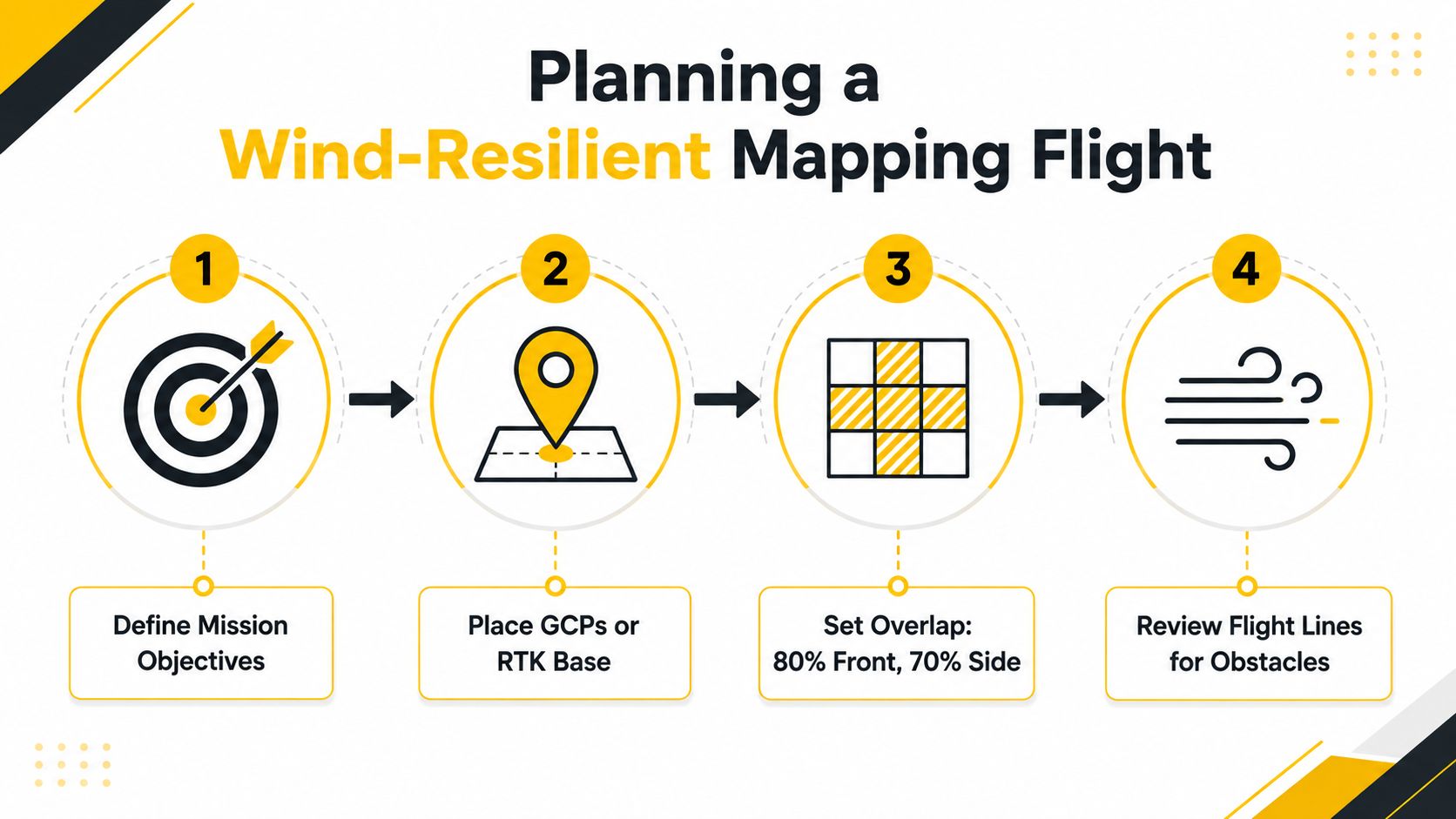
Place ground control points, or establish an RTK base workflow, before the aircraft leaves the vehicle. GCPs help anchor the model to known positions, while RTK can reduce the positioning burden when the aircraft, correction service and workflow are configured correctly.
Flat country allows a more consistent grid. Hilly paddocks need careful terrain following and overlap because changes in ground elevation alter image scale and can weaken the reconstruction. The supplied flight brief uses 80% front overlap and 70% side overlap as a planning reference, but the correct settings still depend on the aircraft, altitude, vegetation and processing platform.
Solar angle matters. Flights should target consistent illumination and avoid the harshest thermal conditions where practical. Midday planning can create turbulence and shifting shadows, while a wind forecast that looks acceptable at ground level may be unsuitable at mapping height. The aircraft's own wind limit remains the controlling figure.
Use a field checklist
- Mission outcome: Name the map and decision required before take-off.
- Control method: Place GCPs or confirm RTK corrections and base-station position.
- Flight grid: Set altitude, overlap, speed and terrain-following parameters.
- Weather window: Check wind, gusts, cloud, shadows and thermal activity.
- Battery plan: Divide the paddock into safe flight blocks with return margins.
- Obstacle review: Inspect trees, towers, powerlines, dams, stockyards and terrain.
- Data validation: Check image coverage, blur, exposure, telemetry and calibration-panel shots.
The operator should review flight lines for obstacles and keep the mission inside the aircraft's operating limits. CASA's guidance for drone operations near airports and other safety-sensitive locations is a useful reference alongside farm-specific risk controls (drone safety around airports and HLS).
ROI, Hidden Costs and Payback on a Mid-Sized Farm
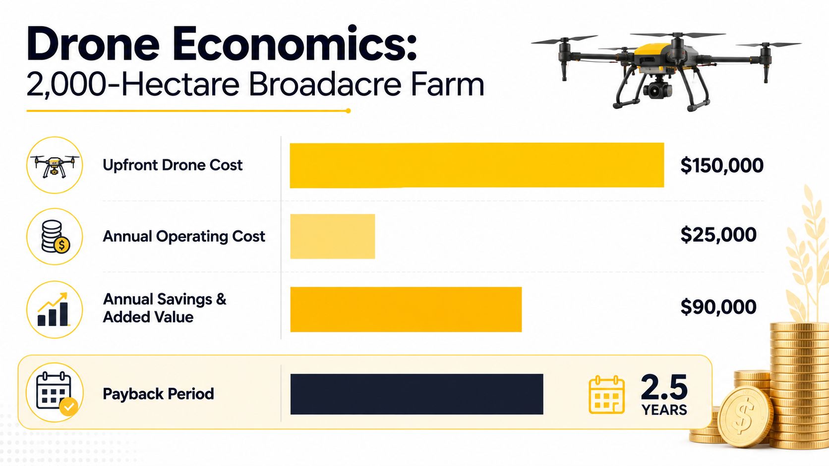
A mapping drone earns its keep only when the resulting map changes a farm decision. On a 2,000-hectare broadacre grain operation, that may mean prioritising drainage work, targeting crop scouting, confirming replant areas, planning variable-rate applications or avoiding unnecessary contractor mobilisation.
Australian Government modelling examined agricultural drone uptake scenarios and valued the medium-scenario impact across agriculture, forestry and fishing at A$3.488 billion (Australian Government economic-benefit analysis). That figure describes sector-wide potential, not the return from one aircraft. Build the business case around the farm's own recurring decisions.
| Cost or value area | What the farm should measure |
|---|---|
| Capital purchase | Aircraft, RTK equipment, payloads, batteries and field accessories |
| Training | Pilot accreditation or RePL pathway, plus any required radio qualification |
| Software | Processing, storage, exports, mapping and prescription workflows |
| Field operation | Staff time, travel, batteries, maintenance and weather delays |
| Agronomic value | Quantify avoided input costs, reduced contractor calls, improved replant decisions or yield changes measured against mapped zones |
Avoid the optimistic spreadsheet
The hidden costs are operational. Orthomosaics and elevation models require storage, consistent file naming, backups and someone who can interpret the results. Batteries wear out, calibration panels need care, and a narrow weather window can force a reschedule. If the crop changes before the replacement flight, the map may no longer answer the original question.
A payback model must record each flight's purpose, the management zone created and the action taken afterward. Compare input use, contractor invoices, replant area, scouting time or yield within mapped zones against comparable untreated or previously managed areas. A map that receives no follow-up action has no demonstrated agronomic value.
Australian Government drone analysis reported a projection of around 38,000 drones deployed for agricultural uses by 2030. Treat that as evidence of a growing operating environment, not as a promise that ownership will pay for a particular farm.
If the team cannot name the decisions that will change each season, use a contractor. Ownership makes more sense when flights are frequent, turnaround matters and staff can manage compliance, processing and maintenance. The 2026 drone business opportunity guide provides useful commercial context, but the final calculation must use local labour, travel, contractor and agronomic figures.
Choosing a Setup by Use Case
The legal pathway comes before the aircraft. Farm geometry and management decisions then determine the platform, pilot arrangement and payload. A citrus block, broadacre grain farm and remote grazing property need different systems.
Horticulture operators
Frequent flights over citrus or other tree crops justify a mid-tier RTK multirotor with a five-band multispectral sensor when irrigation zones, disease scouting and canopy variability drive decisions. Use a RePL-licensed in-house pilot if the team needs information quickly and can manage the associated operating responsibilities.
A multirotor handles tree rows, irrigation infrastructure and isolated problem areas more precisely than a fixed-wing aircraft. RTK improves repeatability between flights, while multispectral imagery can reveal crop-stress patterns that visible imagery may miss. Confirm the operating pathway described in the earlier CASA section before buying, particularly if the proposed work extends beyond routine low-risk flights.
Broadacre grain growers
Beyond 200 hectares, fixed-wing systems paired with a contractor operating under an ReOC framework typically deliver better coverage per dollar. The advantage is practical: the contractor supplies the aircraft, processing workflow, trained personnel and compliance procedures, without leaving the farm to maintain a fleet that may sit idle between campaigns.
For smaller paddocks, irregular boundaries or repeated problem-area work, a multirotor can be easier to deploy. Select the platform around the map required and the decision it must support, not around sensor specifications alone.
Custom airframes, payload integration and specialist commercial UAV manufacturing services make sense only when they solve a defined operating problem. The design still needs to suit the mission, Australian field conditions and the applicable CASA pathway.
Livestock graziers
Start pasture and infrastructure work with RGB mapping. Add selective multispectral flights only where the extra layer will change a grazing, pasture or maintenance decision. RGB is often the more practical first purchase for watering points, access tracks and broad visual checks.
Large remote properties may require a BVLOS-capable operator, subject to the approvals and conditions applying at the time of flight. Refer back to the CASA pathways section before selecting the aircraft or contracting an operator. Confirm the airspace, pilot permissions and operating framework first, then choose a platform that can complete the job without exceeding those limits.
Buyer Questions, Cadastral Limits and Next Steps
An agriculture mapping drone can produce an orthomosaic, elevation model or crop-health layer, but cannot establish legal property boundaries in Australia. Cadastral work must be completed by licensed surveyors using approved methods under relevant state or territory rules, as outlined in Australian surveying guidance (Australian drone surveying guidance).
RTK improves repeatability and positional confidence. It does not make every agricultural map cadastral evidence. Non-RTK imagery remains useful for relative crop comparisons, visual scouting and internal farm planning when its limits are understood.
Drone adoption is growing across Australian agriculture, with mapping among the established use cases discussed in industry and policy material. That growth does not remove the need for competent pilots, safe procedures or correct approvals.
Choose training only after defining the operation. Separate internal work from paid jobs, fleet operations, radio-dependent work and flights requiring more complex approvals. Use the drone licence pathway to compare training options, then find mapping software for sales teams when assessing how field data enters client and commercial workflows.
Define the decision the map must support, confirm the applicable CASA pathway, then shortlist the aircraft and sensor that fit both.
Ace Aviation Aerospace Academy provides CASA-focused drone education for agriculture mapping, including RePL, AROC, ReOC Consulting, Enterprise Drone Training and Corporate Drone Training. Review the options and contact Ace Aviation Aerospace Academy to match the intended work with the appropriate qualification and operating structure.
Frequently asked questions
Can an agriculture mapping drone replace a cadastral surveyor?
No. Drone imagery can support site planning, crop mapping and internal farm decisions, but it cannot establish legal property boundaries. Cadastral work must be performed by a licensed surveyor using approved methods.
Is RTK necessary for farm mapping?
Not always. RGB imagery without RTK can be suitable for visual scouting and relative comparisons. RTK becomes more important when the farm needs repeatable positioning, detailed drainage work or field-scale mapping where positional error would affect the decision.
Does paid mapping work require a RePL?
The requirement depends on the operation, aircraft and business structure. Paid commercial work should be assessed against CASA rules and the operator's intended approvals. A RePL addresses pilot competence, while an ReOC provides an operating framework for businesses undertaking more complex or fleet-based work.
Does a landholder need a RePL to map their own property?
CASA allows a landowner or private landholder to operate a drone in the 2 kg to 25 kg category over their own land for work without a RePL or ReOC when no payment is accepted for the service. Registration, accreditation and operating conditions still apply.
Is multispectral always better than RGB?
No. Multispectral is justified when spectral information will support a defined action, such as crop-stress zoning or variable-rate management. RGB is often the more sensible choice for visual scouting, drainage observation and straightforward field documentation.
Could BVLOS improve large-property mapping?
Potentially. CASA's regional BVLOS consultation work identifies agricultural mapping as an important use case, but operators still need to follow the approvals, airspace rules and operational conditions that apply to the specific mission.
