

Construction site surveying in Australia gets oversold when people treat drones as a total replacement for licensed survey work. They're not. A drone is a fast way to capture site-wide data, but the job still depends on knowing when that data is good enough for progress checks and when it falls short of legally definitive set-out, boundary work, or structural control.
That distinction matters because construction decisions live or die on tolerances. On active sites, survey crews still need to protect line, level, compliance, and chain of responsibility, while drone teams need to understand where photogrammetry adds value without pretending to solve every surveying problem. The best projects use both.
Table of Contents
- Where Drones Actually Fit in Construction Site Surveying
- End-to-End Drone Surveying Workflow for Construction Sites
- Accuracy Standards and Tolerances for Australian Construction Surveys
- Drone Photogrammetry vs Traditional Surveying Methods
- CASA Regulations and Licensing for Commercial Drone Surveying
- Practical Applications for Progress Tracking and BIM Integration
- Building Your Drone Surveying Capability
Where Drones Actually Fit in Construction Site Surveying
The biggest mistake on Australian sites is assuming a drone can stand in for a licensed surveyor. It can't, at least not for cadastral boundaries, structural set-out, or any task that needs sub-centimetre certainty and legal accountability. What drones do well is capture broad, current site information quickly, especially where crews would otherwise spend hours walking unsafe ground or revisiting changing earthworks.
The jobs drones handle well
Drone photogrammetry is practical for open-site progress mapping, stockpile volumes, and earthworks monitoring when the site has good control and independent checkpoints. Australian guidance places a workable planning band at around 20 to 50 mm horizontal and 30 to 100 mm vertical accuracy in suitable conditions, which is enough for many operational decisions on construction sites. That's why drone outputs are often useful for tracking cut and fill movement, checking whether work has advanced as expected, and creating a site-wide visual record before crews move in on the ground construction roof inspection guide.
Practical rule: if the question is, “What changed across the site?”, drones are often a strong fit. If the question is, “What is the legally exact point on the ground?”, a licensed survey method still matters.
That split lines up with how Australian teams are using drone data in practice, including site tracking, design support, and project control workflows rather than just aerial imagery. The drone becomes part of the measurement chain, not a novelty tool. The workflow only holds up when control, checkpoints, and data processing are treated as seriously as the flight itself.
Where drones should stop
Drones are not the right tool for cadastral work or any boundary decision that carries legal consequences. They also don't replace survey methods for structural set-out, where Main Roads Western Australia specifically cautions against using its Construction Surveying Guideline for vertical set-out on sub-base, base-course final level, or structural set-out. That's the sort of warning site teams should take seriously, not creatively.
For people comparing airborne data with field survey capability, AAA's drone ecosystem overview is a useful reference point for how drone operations sit inside a wider aviation workflow. The key takeaway is simple, drones expand coverage, they don't erase survey responsibility.
End-to-End Drone Surveying Workflow for Construction Sites
A reliable drone survey starts before the aircraft leaves the ute. Mission planning should define the area of interest, identify hazards, set flight height and overlap targets, and confirm whether the site can support clean image capture. Good planning matters because processing software can only work with the geometry and ground control it receives.
Plan for control, not just coverage
The strongest construction workflows use well-distributed ground control points and independent checkpoints. That means placing control across the site, not clustering it near one access point or one pad. RTK and PPK workflows can reduce the amount of ground control needed, but they don't remove the need to validate the model against checkpoints before anyone accepts the deliverable.
Good drone work is repeatable. If the same site is flown next week, the team should know whether the differences reflect real change or a weaker setup.
That is why stable control transfer matters more than the aircraft model itself. Camera geometry, checkpoint residuals, and site conditions all influence whether the output is trustworthy. On fast-changing construction sites, repeatability is the key advantage, because the same method can be applied again and again as the surface changes.
Capture, process, validate
During capture, the operator needs sharp images, consistent coverage, and a workflow that copes with changing ground conditions. Open trenches, new plant, stockpiles, and temporary structures can all alter the scene between flights. The point is to collect data that survives processing, not just data that looks complete on the screen.
Processing turns overlapping images into deliverables that crews can use, usually orthomosaics, digital surface models, point clouds, contours, and quantity outputs. Before those products are accepted for progress claims or project decisions, checkpoint validation needs to show that the model behaves within the site's tolerance expectations.
A practical workflow looks like this:
- Mission planning, define the survey area, safety limits, and control strategy.
- Flight capture, collect consistent imagery or sensor data across the site.
- Processing, generate surfaces, maps, and measurement products.
- Validation, check residuals and compare deliverables against checkpoints.
For beginners who need structured training before they touch a construction workflow, ACE READY is an entry-level drone course that covers drone fundamentals, aviation safety, CASA regulations, and flight operations, and it prepares students for later RePL training.
The same discipline shows up in emergency and safety documentation too, which is why this emergency handbook is relevant for operators building a professional habit around planning and risk management. Construction sites reward the teams that treat the drone flight as one step in a controlled survey chain.
Accuracy Standards and Tolerances for Australian Construction Surveys
Drone photogrammetry sounds impressive until it's measured against actual construction tolerances. In suitable conditions, a good workflow can sit in the 20 to 50 mm horizontal and 30 to 100 mm vertical planning range, but that range isn't a universal guarantee. It depends on control transfer, camera geometry, and whether checkpoints confirm the result rather than just the software's internal fit.
What the numbers mean on site
Queensland TMR's MRTS56 Construction Surveying specification requires horizontal survey uncertainty to be less than 0.015 m at the 95% confidence level, unless otherwise specified, and some works require independent checks using alternative measurement techniques to achieve ±25 mm. Those are real project controls, not abstract targets, and they show why drone outputs must be tested against the job's tolerance, not against a marketing claim Queensland TMR MRTS56 specification.
| Specification / Method | Horizontal Accuracy | Vertical Accuracy | Suitable Applications |
|---|---|---|---|
| Drone photogrammetry in good conditions | Around 20 to 50 mm | Around 30 to 100 mm | Progress mapping, earthworks tracking, stockpile volumes |
| Queensland TMR MRTS56 requirement | Less than 0.015 m at 95% confidence | Not stated in the verified data | Construction survey tasks requiring strict control |
| Works needing alternative measurement checks | ±25 mm | ±25 mm where specified | Sensitive set-out and verification tasks |
The table shows the practical gap. Drone data can be operationally useful without being good enough for every construction decision. That's not a weakness, it's a boundary that teams need to respect.
What drives error
The main error sources are usually familiar to working surveyors. Poorly placed GCPs, weak camera geometry, and unvalidated checkpoints can degrade the result faster than most operators expect. On active sites, the surface also changes between capture and processing, which can distort comparisons if the team assumes the site stayed static.
Australian guidance also makes a point that drone outputs are suitable for open-site progress mapping and earthworks surfaces, but not cadastral or legal boundary work, which still requires licensed survey methods and sub-centimetre standards. That distinction is the difference between a useful project tool and an overreach. For construction managers, the key question is not whether a drone can create a model, but whether that model satisfies the task's tolerance and accountability requirements.
Drone Photogrammetry vs Traditional Surveying Methods
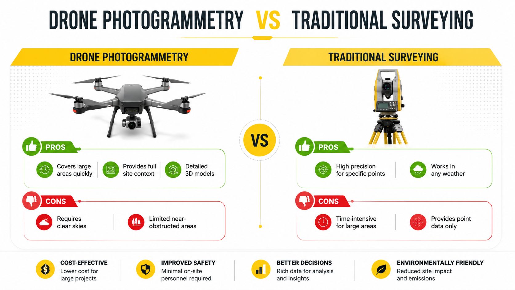
Drone photogrammetry and traditional surveying methods solve different problems on Australian construction sites. Drones cover space quickly and give teams a current view of the whole site. Total stations, GNSS rovers, and terrestrial laser scanners still do the better job when the task needs high precision at specific points, tight vertical control, or work in obstructed conditions.
Choosing the right tool for the task
A total station remains the clean choice for structural set-out and detailed point work. GNSS rovers suit fast point collection when crews have open sky and a stable satellite fix. Terrestrial laser scanners help where dense geometry or as-built detail matters, but they still depend on line of sight and the practical realities of plant, trade crews, and access barriers.
Drone photogrammetry works best on large, open sites where the team needs a fresh surface model or a clear progress picture. It also reduces exposure on incomplete, unstable, or hazardous ground. The trade-off is straightforward. The drone gives broad coverage, but the result still depends on control, visibility, and the quality of the imagery captured on site.
How LiDAR fits in
LiDAR-equipped drones are useful where terrain sits under vegetation or where photogrammetry struggles to define the ground surface cleanly. They sit alongside photogrammetry rather than replacing it. The right choice comes down to site conditions, the deliverable, and whether the team needs surface texture, bare-earth information, or both.
A simple comparison helps:
- Drone photogrammetry: best for open areas, progress tracking, orthomosaics, and volumetrics.
- Total stations: best for precise set-out, control points, and verification.
- GNSS rovers: best for flexible point capture where satellite visibility is strong.
- Terrestrial laser scanners: best for detailed as-built capture and complex geometry.
- Drone LiDAR: best for terrain modelling where vegetation blocks a clean optical surface.
For teams weighing method, timing matters too. The 2026 year-end drone business opportunity at the 2026 year-end drone business opportunity may sharpen the commercial case, but the technical decision stays the same. Use the method that suits the task, not the one that sounds newer.
Construction teams get the best results when they match the method to the deliverable. Drones are strong for progress mapping and volumetrics. Total stations, GNSS, and scanners still carry the load where legal set-out, tight tolerances, and accountable control are on the line.
CASA Regulations and Licensing for Commercial Drone Surveying
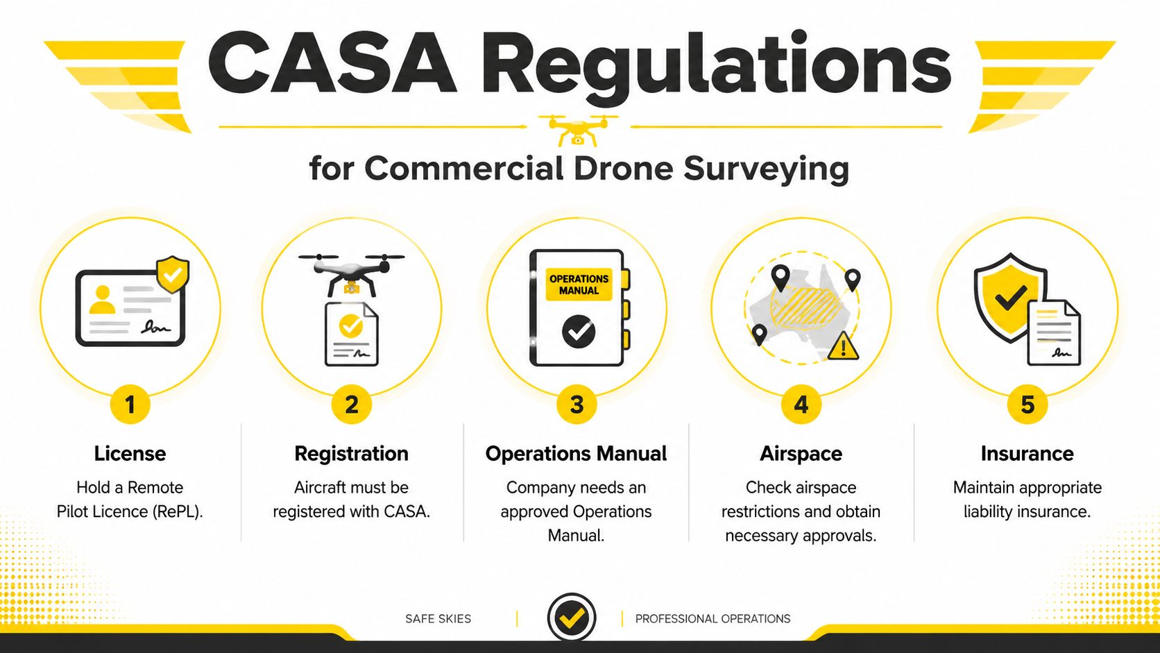
Commercial drone surveying on Australian construction sites sits inside CASA's operating rules, and those rules are not optional. A commercial drone must stay within the general operating limit of 120 m above ground level and at least 30 m from people not involved in the operation, and commercial drones must be registered with CASA for 12 months CASA registration and operating limits overview.
What operators need to have in place
For many commercial jobs, the operator pathway starts with the Remote Pilot Licence (RePL), which supports lawful commercial RPAS operations. Where work approaches controlled airspace or other radio-dependent environments, the Aeronautical Radio Operator Certificate (AROC) becomes relevant. Organisations operating drones commercially may also need a Remote Operator Certificate (ReOC) so the business has the right approvals and systems in place.
That regulatory stack matters because construction sites often sit near roads, infrastructure corridors, or active airspace constraints. A drone team that understands set-up, airspace, and operational limits reduces the chance of failed flights and compliance problems. The point is not paperwork for its own sake, it's keeping the operation lawful and defensible.
Training and compliance support
Ace Aviation Aerospace Academy offers training and advisory pathways that line up with those needs, including RePL, AROC, Enterprise Drone Training, and ReOC Consulting. Those options are relevant where construction teams need both operator competence and a compliance system that can survive real work, not just classroom theory.
For teams that want a broader overview of the Australian drone rule set, this 2026 drone laws guide is a practical companion reference. It helps place survey operations inside the wider operating environment rather than treating them as isolated flights.
Practical Applications for Progress Tracking and BIM Integration
Drone surveying earns its keep when the data feeds real construction decisions. On Australian projects, orthomosaics and digital surface models are often used for pre-construction design checks, ongoing progress comparison, cut and fill monitoring, and stockpile measurement. That's where a repeatable workflow matters, because the same control framework can show whether a site is moving as designed or drifting away from the model.
What this looks like in practice
A project team can fly a site before bulk earthworks begin, then repeat the same capture path later to compare surface changes against the design. That comparison helps project managers see whether a pad is forming correctly, whether material has been moved where it should have been, and whether stockpiles line up with the quantities expected for payment or haulage planning. The outputs are useful because they are visual, measurable, and easy to share with engineers, supervisors, and clients.
BIM integration sharpens that value. When a drone-generated surface is aligned with design models, the project team can spot deviations early instead of discovering them after a concrete pour or a drainage setback. That matters most on fast projects, where a missed level or misplaced edge can turn into rework, delay, or compliance trouble.
A few applications stand out:
- Design verification, checking whether the site is being prepared to the intended geometry.
- Progress reporting, showing what has changed since the last capture.
- Earthworks control, comparing cut and fill volumes against plan.
- Stockpile validation, supporting contractor claims with measurable surface data.
- Safety support, reducing the need to send crews onto incomplete or unstable ground.
Why workforce constraints matter
Australia's surveying and geospatial profession was estimated at around 19,000 workers in 2021/22, including about 6,300 surveyors, 8,500 spatial scientists and survey technicians, and 4,200 allied professionals. Queensland alone accounted for 71.9% of that total workforce, and the same study said the number of surveyors had increased by 42.3% while registered/licensed surveyors had fallen to just under 2,400, down 7.7% national surveying workforce study. That shortage is one reason drone workflows are being used more deliberately on active sites.
The broader market also matters. Australia's surveying and mapping services industry was valued at $3.9 billion in 2026 and contained 3,611 businesses, with business count growth of 0.3% between 2021 and 2026 industry analysis. Those figures reflect a mature support sector that keeps construction, infrastructure, and land development moving.
For teams looking at how digital delivery fits into real engineering work, this engineering case example is a useful reminder that controlled workflows and good data management matter more than flashy capture tools. Drone surveying works best when it feeds an organised project system, not a pile of loose files.
Building Your Drone Surveying Capability
The practical formula is straightforward. Use drones for what they're good at, broad coverage, repeatable progress tracking, and volumetrics. Keep licensed survey methods for boundaries, structural set-out, and any task that needs definitive control or strict compliance.
That means capability building should focus on three things, control, validation, and regulatory discipline. Teams that learn how to place GCPs properly, check residuals, and work within CASA rules get much more from drone data than teams that just buy aircraft and hope the output is precise enough. The same applies to people entering the field, basic flight skill is not enough without survey thinking.
For operators and businesses that want training aligned to Australian commercial work, Ace Aviation Aerospace Academy offers pathways that include course options such as Remote Pilot Licence (RePL), Aeronautical Radio Operator Certificate (AROC), Certificate III in Aviation, and Enterprise Drone Training. Those programs are most useful when the goal is to build survey-ready drone operations rather than casual flying.
If construction teams want drone data they can rely on, Ace Aviation Aerospace Academy can help build the operating discipline behind it, from flight training to radio and compliance capability. Visit Ace Aviation Aerospace Academy to explore training that supports commercial drone work on Australian construction sites and helps operators move from capture to confident project use.
FAQ
Can drones replace a surveyor on a construction site?
No. Drones are useful for progress mapping, volumetrics, and site monitoring, but legally definitive boundary work and structural set-out still need licensed survey methods.
What accuracy can drone photogrammetry achieve on construction sites?
In suitable Australian conditions, planning accuracy is typically around 20 to 50 mm horizontal and 30 to 100 mm vertical, provided the workflow uses good control and checkpoint validation.
Do commercial construction drones need CASA registration?
Yes. Commercial drones must be registered with CASA, and registration is valid for 12 months.
When is a total station still the better choice?
A total station is usually the better choice for structural set-out, detailed point control, and any work that needs very tight precision.
Can drone data be used for boundary definition?
No. Boundary and cadastral work still requires licensed survey methods, not drone photogrammetry alone.
Why does checkpoint validation matter so much?
Because the processing software's internal fit isn't enough on its own. Checkpoints show whether the final deliverable is accurate enough for the construction decision being made.
