

A council has asked for a habitat survey after a bushfire. A land manager wants a defensible map before the next rehabilitation stage. A commercial pilot has the aircraft, but the harder question remains: what must be captured, how should it be captured, and what makes the result useful to an ecologist?
Drone environmental monitoring is more than flying over trees and delivering photographs. It combines aviation planning, sensor selection, repeatable data capture, geospatial processing, ecological knowledge and Australian regulatory compliance. The aircraft is only one part of the system.
Table of Contents
- What Drone Environmental Monitoring Actually Means
- Sensors and Platforms Used in Environmental Work
- How a Monitoring Mission Is Planned and Flown
- Where Drones Are Used Across Australian Environments
- Turning Raw Drone Data into Meaningful Insights
- CASA Rules and Licensing for Monitoring Operations
- Training Pathways for Aspiring Environmental Drone Pilots
- Key Takeaways and Frequently Asked Questions
What Drone Environmental Monitoring Actually Means
A fixed-wing aircraft moves along a dry eucalypt ridge after a bushfire, following a planned corridor above surviving canopy patches. Its camera records overlapping images that later become a map of burn severity and regeneration. On another job, a multirotor follows slow transects over koala habitat in New South Wales, while a thermal payload helps locate animals that are difficult to see from the ground.
That is drone environmental monitoring in practical terms. An unmanned aircraft carries imaging or other sensors to gather repeatable, georeferenced information about ecosystems, habitats, water bodies, vegetation condition and environmental damage. The output isn't only aerial photography. It may be an orthomosaic, a vegetation index layer, a three-dimensional habitat model, a thermal anomaly map or a wildlife count.
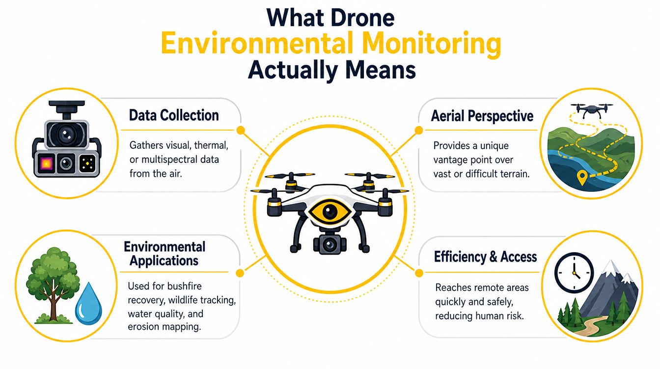
The three working pillars
Data collection comes first. The operator captures imagery or measurements with enough overlap, positional accuracy and consistency to support later comparison. A single attractive image rarely answers an environmental question. A repeatable flight does.
Sensor choice follows the question. A standard RGB camera may suit weed mapping or photogrammetry. A multispectral payload can help assess vegetation reflectance. Thermal imaging may support wildlife detection or hotspot surveys. The sensor must measure something relevant to the decision being made.
Workflow and interpretation turn raw files into evidence. TERN describes its drone remote sensing program as a standardised, nationwide ecological data collection program, demonstrating that UAVs can form part of a formal ecological data pipeline rather than being used only for ad hoc photography (TERN's drone remote sensing program).
Australian programs show that this work is already operational. The NSW Wildlife Drone Hub recorded 4,957 drone flights across 21,452 kilometres and identified 12,054 animals, including 1,276 koalas, by November 2023 (NSW Wildlife Drone Hub). A later NSW summary reported 4,369 flights over 19,038 kilometres and 16,368 animals found, including 981 koalas, showing an established government workflow rather than a one-off experiment.
Sensors and Platforms Used in Environmental Work
The right payload depends on the environmental signal being measured. A camera that works well for mapping a cleared site may be unsuitable for identifying animal heat signatures or assessing subtle vegetation stress.
Matching sensors to the question
RGB cameras capture the visible colour spectrum. They support photogrammetry, orthomosaics, basic land-cover classification, erosion mapping and weed surveys. A properly planned series of overlapping RGB photographs can create a scaled map that shows tracks, bare ground, canopy gaps and rehabilitation boundaries.
Multispectral cameras record selected bands beyond ordinary visible imagery. Reflectance differences can be converted into indicators such as NDVI or NDRE, which help operators compare vegetation condition across a site. Queensland's Department of Primary Industries reports drone use for monitoring vegetation stress, nutrient deficiency, pests, disease and crop variability with multispectral cameras, thermal sensors and NDVI imaging (Queensland DPI drone applications).
Thermal cameras measure emitted heat rather than visible colour. They can support nocturnal wildlife surveys, hotspot detection and investigation of temperature differences in vegetation or water. Results depend heavily on canopy cover, ambient conditions, timing and the animal's visibility.
LiDAR produces three-dimensional measurements that can reveal terrain shape, canopy structure and tree height. It can be useful where the question concerns vertical structure, although dense vegetation and payload weight affect platform selection.
Hyperspectral systems collect much narrower spectral information than common multispectral cameras. They can support detailed research into vegetation chemistry and material differences, but the data requires specialist calibration and analysis.
| Sensor | Measurement | Best Australian application | Platform fit |
|---|---|---|---|
| RGB | Visible imagery and image geometry | Orthomosaics, erosion and weed mapping | Multirotor or fixed-wing |
| Multispectral | Reflectance across selected bands | Vegetation stress and habitat condition | Multirotor for targeted sites |
| Thermal | Surface temperature differences | Wildlife surveys and hotspot checks | Multirotor for controlled transects |
| LiDAR | Three-dimensional structure | Terrain and canopy modelling | Aircraft with suitable payload capacity |
| Hyperspectral | Detailed spectral response | Vegetation and material research | Specialist platform and workflow |
Choosing between multirotor and fixed-wing aircraft
A multirotor can hover, launch from a compact area and fly slowly over a defined target. That makes it suitable for small habitat patches, vertical inspections, detailed transects and missions that need precise positioning.
A fixed-wing platform generally suits larger corridors and broad-area surveys where endurance and efficient forward flight matter more than hovering. The operator still needs a suitable launch and recovery plan, and the aircraft can be less convenient in confined or obstructed locations.
Agricultural operators comparing drone platforms can also review the XAG P150 Max and Australian agriculture context, although environmental monitoring requirements may differ from spraying or spreading operations. For a beginner building foundational knowledge before advanced RePL training, ACE READY covers drone fundamentals, aviation safety, CASA regulations and flight operations.
How a Monitoring Mission Is Planned and Flown
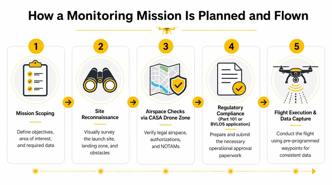
A competent environmental pilot starts with the question, not the aircraft. The project brief should identify the area of interest, the environmental feature being measured, the required accuracy, the timing window and the final format expected by the client.
From site assessment to flight plan
The operator then checks the launch location, landing area, obstacles, terrain, powerlines, people, wildlife sensitivities and access arrangements. Airspace and operational information must be checked through CASA's Drone Zone, alongside the applicable Part 101 requirements, permissions and any relevant operational approvals.
Ground control points may be placed across the survey area when the project requires stronger geospatial control. Multispectral flights also need attention to weather, illumination and solar angle. Changing cloud, glare and shadow can make repeated datasets harder to compare.
Flight planning software such as DJI Pilot, Pix4D or UgCS can define altitude, overlap, grid orientation and waypoints. The settings should reflect the terrain and sensor, not just a default template.
Execution and data quality
Before launch, the pilot checks the aircraft, batteries, payload, control link, navigation information, storage, return settings and emergency procedures. During the grid flight, the operator monitors wind, glare, changing light, unexpected people or animals and any loss of data quality.
Practical rule: A complete flight log and clear site notes can be as valuable as the imagery when another analyst needs to understand how the dataset was produced.
Processing may take place in Pix4D, Agisoft or ArcGIS. Typical deliverables include orthomosaics, digital surface models, NDVI maps, thermal layers and change-detection outputs. The client may be an ecologist, council, land manager, researcher, government agency or Traditional Owner organisation, so the report must explain findings in operational language rather than leaving stakeholders with a folder of image files.
For long coastlines, river corridors or remote post-fire work, the operator may need a different approval pathway. CASA announced new BVLOS trial approval pathways in September 2025 to support environmental monitoring, agriculture, emergency services and infrastructure inspection (CSIRO GISERA discussion of drones, satellites and biodiversity). Operators considering that pathway can review BVLOS operational information. A package such as ACE PLATINUM includes RePL, AROC, Aviation English, Express ReOC, Certificate III in Aviation, advanced operations training and preparation to operate and manage a commercial drone business.
Where Drones Are Used Across Australian Environments
Environmental missions look different on the ground. A wildlife survey may require quiet, slow transects at a carefully selected time. A post-fire assessment may prioritise rapid coverage and clear change mapping. A vegetation project may need consistent illumination, while a shoreline survey depends on tide, wind and water conditions.
| Mission type | Primary sensor | Australian example | Flight profile |
|---|---|---|---|
| Wildlife and biodiversity surveys | Thermal and RGB | NSW Wildlife Drone Hub koala and animal surveys | Slow transects, often timed for detectability |
| Vegetation and habitat mapping | RGB and multispectral | Habitat condition, forestry and rehabilitation mapping | Grid flights with repeatable overlap |
| Water and aquatic monitoring | RGB, thermal or specialist payloads | Coastal, river, reservoir and reef assessments | Shoreline or transect-based coverage |
| Pollution and contamination events | RGB, thermal or multispectral | Bushfire, flood and spill response mapping | Rapid deployment over defined impact areas |
Wildlife and biodiversity
Thermal drones can help locate animals against cooler surroundings, while RGB imagery provides habitat context. In Victoria, University of Melbourne research found thermal drones surveyed up to 10 times more forest area than traditional spotlighting and recorded more than 1,000 observations of native mammals and other fauna (University of Melbourne research reference). That result doesn't remove the need for field validation. Canopy density, animal behaviour, night conditions and species detectability still influence the outcome.
Vegetation and habitat mapping
A multispectral grid over koala feed trees, pasture or a mine rehabilitation plot can reveal patterns that aren't obvious in ordinary photographs. The operator must maintain consistent altitude, overlap and lighting so later flights can be compared.
Water and aquatic monitoring
Operators may map shorelines, sediment movement, algal indicators or thermal differences across a reservoir, river or coastal area. The aircraft captures the spatial picture, while water sampling and field observations may be needed to explain what the image shows.
Pollution and disaster response
After a bushfire, flood or chemical spill, a drone can provide a current map of affected areas while keeping personnel away from unsafe ground. Remote-area work is also becoming relevant to Indigenous ranger groups. In June 2025, the Department of Agriculture, Fisheries and Forestry reported workshops for Indigenous ranger groups in Queensland and the Northern Territory focused on detecting ghost nets and marine debris in remote coastal regions (reported Indigenous ranger workshops).
Turning Raw Drone Data into Meaningful Insights
A drone returns files, not conclusions. The useful question is whether those files support a defined environmental decision, such as locating erosion, checking rehabilitation progress or prioritising a field inspection.
The processing chain
Photogrammetry software aligns overlapping photographs and uses shared features to create an orthomosaic, a geometrically corrected image that can be measured. The same flight may produce a digital surface model and dense point cloud, allowing analysts to examine terrain, canopy height, stockpiles or erosion.
Multispectral imagery needs calibration and band checks before an operator calculates an index such as NDVI or NDRE. A rehabilitation manager can compare stronger and weaker vegetation responses, select areas for inspection and decide where further treatment or watering deserves attention. These indices indicate patterns. They do not diagnose the cause by themselves.
Thermal processing displays temperature differences. In a Victorian wildlife survey, University of Melbourne research found thermal drones surveyed up to 10 times more forest area than traditional spotlighting and recorded more than 1,000 observations of native mammals and other fauna (University of Melbourne research). Field validation still matters because canopy density, animal behaviour, night conditions and species detectability can affect results. Rocks, exposed soil, sun-warmed surfaces and other heat sources can also create false positives.
Analysis and reporting
Wildlife and weed projects may require manual annotation, object counting or machine-learning classifiers. Local training data matters. A model developed for one species, habitat or lighting condition may perform poorly elsewhere.
Data quality starts before take-off. Poor overlap, changing light, weak positioning or missing metadata can limit every map produced later.
A useful report states what was measured, how it was captured, which limitations apply and what action the stakeholder can take. Operators building these processing and specialist workflows can explore specialised drone training.
CASA Rules and Licensing for Monitoring Operations
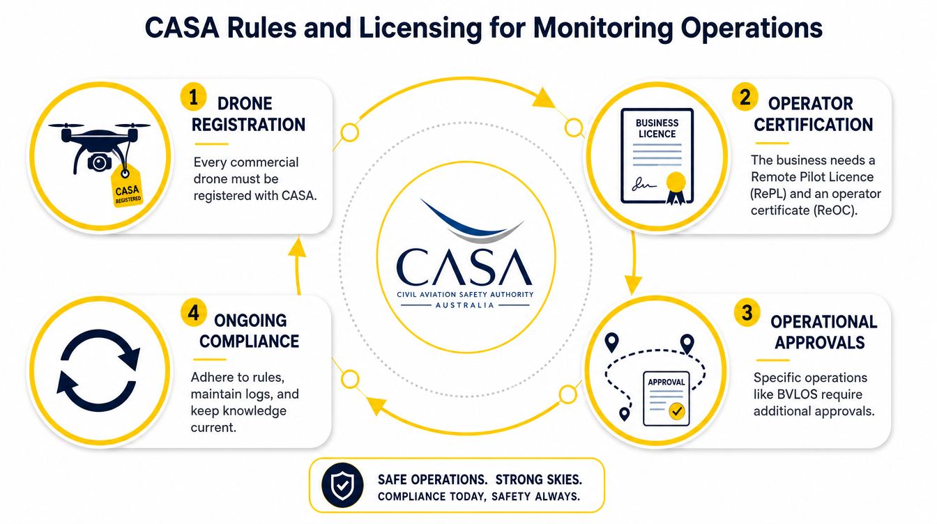
Environmental monitoring flights undertaken for business or as part of a job fall within CASA's commercial drone requirements. CASA states that any drone used for business purposes or as part of a job must be registered, regardless of its weight, and lists monitoring, surveillance, research and development, aerial photography and infrastructure inspection among covered activities (CASA registration requirements).
The operating baseline sits under Part 101 of the Civil Aviation Safety Regulations. CASA's published drone safety rules should be treated as the controlling reference for current operations, rather than informal industry habits.
The operator and organisation
An individual undertaking commercial remote piloting generally needs the appropriate Remote Pilot Licence, while an organisation conducting commercial operations generally needs a Remotely Piloted Aircraft Operator's Certificate. The exact operational setup, aircraft category and approvals determine what a particular business can accept and conduct.
Common operating constraints affect environmental work directly. These include the standard 400-foot height limit, separation from people, daylight operation requirements and the need to manage visual line of sight unless an approval permits otherwise. CASA's detailed rules and any operation-specific conditions must be checked before each mission.
Land access, privacy and BVLOS
CASA approval doesn't replace landowner or land manager consent. Parks, reserves and Indigenous land may have their own access, cultural heritage, wildlife and research conditions. Environmental operators should secure permission early and document who authorised the work.
Imagery can also create privacy issues when identifiable people, homes or private property are captured. The operator should consider the Privacy Act and applicable state or territory requirements, limit unnecessary collection and handle files securely.
BVLOS operations create another layer. CASA's September 2025 environmental monitoring trial pathway indicates that the regulatory system is developing around longer-range missions, but operators still need the relevant approval and risk controls. A practical overview of Australian drone laws in 2026 can help identify issues that require confirmation before a job is accepted.
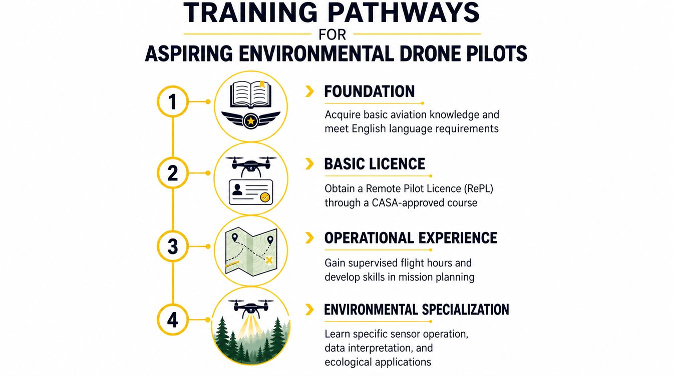
Training Pathways for Aspiring Environmental Drone Pilots
A new operator usually starts with aviation fundamentals rather than a specialist sensor. The early stage includes understanding airspace, weather, human factors, aircraft limitations and aeronautical English. These foundations help a pilot interpret procedures and communicate safely before environmental complexity is added.
From basic flying to commercial work
A Remote Pilot Licence provides the core credential for the relevant operation and aircraft category. Training also develops practical control, emergency responses, pre-flight planning and operational decision-making. A multirotor endorsement may suit many habitat and vegetation missions, while fixed-wing or advanced operations may require additional competency.
The next stage is supervised operational experience. A pilot learns to manage launch sites, observers, payloads, batteries, data storage and changing field conditions while working within an organisation's procedures. Environmental work adds another layer because the ideal ecological window may conflict with wind, light, access or wildlife sensitivity.
Building environmental capability
A capable specialist can connect the flight to the scientific question. That includes sensor calibration, photogrammetry, multispectral processing, thermal interpretation, ground control, field validation and clear reporting. Work around koala breeding periods, turtle nesting areas or prescribed-burn recovery also requires coordination with ecologists and land managers.
The Aeronautical Radio Operator Certificate can be relevant where operational communications require aviation radio competency. A Certificate III in Aviation may support a broader aviation foundation, while ReOC Consulting is relevant to organisations developing commercial operating systems. Enterprise Drone Training and Corporate Drone Training can suit businesses or government teams that need capability across multiple personnel.
ACE's drone training courses provide a place to compare pathways such as RePL and related aviation training. Advanced operations, including BVLOS trials, should be approached only after the operator has the appropriate foundation, documented procedures and approval pathway.
Key Takeaways and Frequently Asked Questions
The essential points are straightforward:
- Match the sensor to the question: RGB, multispectral, thermal, LiDAR and hyperspectral payloads produce different kinds of evidence.
- Design a repeatable workflow: Mission scope, site checks, flight settings, metadata and processing all affect the result.
- Treat CASA compliance as part of the job: Commercial drones must be registered, and operations must follow Part 101 and any additional approval conditions.
- Develop more than flying skill: Processing, ecological interpretation, field validation and reporting determine whether the dataset supports a sound decision.
- Plan for scale carefully: Drones provide detailed local information, while satellite integration can help extend monitoring across larger regions, as discussed by CSIRO's GISERA (drones, satellites and biodiversity).
Frequently asked questions
Is a standard RePL enough for environmental monitoring?
A RePL is a baseline credential for the applicable operation, but it doesn't by itself teach every sensor, processing workflow or ecological method. Operators still need practical competence in mission planning, data capture and interpretation.
How are CASA BVLOS rules changing?
CASA introduced BVLOS trial approval pathways in September 2025 for areas including environmental monitoring. The pathway is approval-based, so operators must confirm current requirements rather than assume ordinary visual-line-of-sight privileges extend to BVLOS work.
What software is used for NDVI and orthomosaics?
Common workflows use Pix4D, Agisoft and ArcGIS, with flight planning often handled through DJI Pilot, Pix4D or UgCS. The correct software depends on the sensor, required output and client's existing GIS workflow.
How long does a survey take per hectare?
There isn't a universal time. Survey duration changes with aircraft type, terrain, sensor, overlap, weather, access, battery management and whether ground control or repeat passes are required.
Where should a beginner start?
A beginner should build aviation and drone fundamentals first, then progress into the relevant RePL pathway and supervised commercial experience. Environmental specialisation should follow once safe, compliant flight operations are established.
The next practical step is to define one environmental question and identify the training, sensor, and approval pathway it requires.
Ace Aviation Aerospace Academy provides training pathways relevant to environmental drone work, including RePL, AROC, Certificate III in Aviation, ReOC Consulting and enterprise or corporate drone training. Review the available options at Ace Aviation Aerospace Academy and match the pathway to the intended operation.
