

Why a paddock template fails on a building site. A risk assessment that reads well on paper can fail the moment a drone leaves the vehicle. A paddock with a creek boundary, a live crane on a construction site, a flood-affected road and a city bridge with overhead power lines each need different hazard identification and controls. The six sectors below show how Australian operators in urban inspection, construction, agriculture, emergency response, media production and surveying build and adapt their risk assessments, with the CASA considerations, mitigations and template fields that matter in each case.
Table of Contents
- 1. Urban Building and Infrastructure Inspection
- 2. Construction Site Drone Operations
- 3. Agricultural Drone Operations and Crop Monitoring
- 4. Emergency Response and Disaster Assessment
- 5. Aerial Photography and Media Production
- 6. Infrastructure Survey and Mapping Operations
- 6-Point Drone Risk Assessment Comparison, Australia
- Adapting a Template to Your Own Operation
1. Urban Building and Infrastructure Inspection
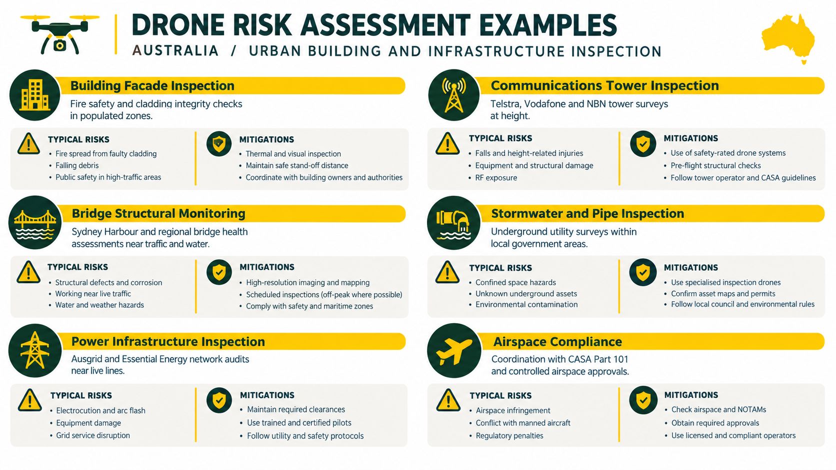
A CBD facade job can fail before take-off if the site contact has not confirmed the launch point, the airspace, and the recovery area. The same applies to a bridge survey over traffic or a tower inspection beside live communications gear. In urban work, the first question is where the aircraft can legally and safely fly, because CASA's standard operating conditions and airspace rules shape that answer, and city jobs often run into controlled airspace, public access, or both (CASA drone rules).
What the register needs to capture
The hazard register for urban inspection work should name the structure, nearby pedestrians, the nearest aerodrome or helipad, and the exact launch and recovery point. It should also record the maximum operating height, visual observer position, emergency landing areas, contact with building management or site security, and the stop-work trigger if people enter the area. A facade in a quiet industrial estate and a bridge near road or rail traffic are not the same job, and the controls should show that difference.
The practical trade-off is simple. Tight urban access often gives better image quality, but it leaves less room for error, less room for recovery, and more people who can interrupt the flight.
Practical rule: if the aircraft can stay within the approved area only because everyone else is expected to “just stay clear”, the plan is too weak.
A useful template also needs fields for GPS coordinates, flight path notes, observer names, and any approvals or access permits from councils or asset owners. When handing the assessment to an asset owner, structure it the way a source inspection guide organises evidence and sign-off, so the reviewer can trace each hazard to a control. That format helps when the asset owner wants to see who approved access, which area was closed, and what evidence supports the go, no-go call.
That is where generic templates fail. They leave out the stakeholder handover and the airspace check, which are the first things that matter when the site sits near controlled airspace or active public use.
A good starting point for new crews is ACE READY, a beginner course that covers drone fundamentals, aviation safety, CASA regulations, and flight operations before RePL training. It suits early-stage operators who need the basics clear before they sign off work around occupied buildings or infrastructure.
Before quoting a CBD facade job, re-read the drone laws overview for Australian operators and confirm whether controlled airspace approval changes your launch point. For operators building their own reference set, the most useful checks are still direct. Confirm the airspace, brief the site contact, and write down who can call the job off.
2. Construction Site Drone Operations
Construction sites change by the hour, so a static risk assessment usually ages badly. A drone that was safe at dawn can be unsafe after a tower crane arrives, a delivery truck parks in the recovery zone, or a subcontractor opens a new work area. The hazard register has to be live, not archived.
Site control matters more than the camera task
Progress documentation, volumetric checks and site mapping all depend on coordination with the site safety officer and the project manager. The controls need to reflect moving plant, temporary structures, workers on different levels, and dust that can affect visibility and equipment. Dust and debris also belong in the pre-flight check, especially around vents and sensors.
A construction template should include daily walkabout notes, current machinery positions, exclusion zones, and the exact project stage being flown. It should also identify the buffer around active plant and work platforms at height, along with the person responsible for clearing the landing area before take-off. A generic “site is safe” checkbox is not enough when the site is changing every shift.
A drone job on a building site fails most often because the operator planned for the drawing, not the live site.
The most useful controls are procedural. That means briefing ground crews, wearing high-visibility clothing where required, setting flight windows around lower-activity periods, and stopping when unexpected activity starts near the operating area. If the site team cannot support those controls, the flight should move or wait, not push through.
For teams managing mixed aviation and ground risk, Ace Aviation's airport and helicopter landing site safety guide is a useful related read because the same discipline, airspace separation, observer roles and stop-work thresholds, applies when cranes, roofs and heavy plant are in play.
3. Agricultural Drone Operations and Crop Monitoring
Farm work looks open and simple until the drone meets wind, fences, spray drift or a low aircraft transit. Agricultural risk assessments need to account for terrain, boundary lines, water, livestock, and the fact that the operating area can be very large but still tightly constrained by airspace and weather. A paddock map alone does not tell the whole story.
Field hazards need field-specific controls
Crop monitoring, irrigation planning, spraying and seed spreading each carry different consequences if the aircraft drifts off line. A monitoring flight near a dam, vineyard edge or irrigation channel needs different controls from a broad crop-health survey over flat cereal country. The assessment should spell out wind direction, terrain features, nearby farm machinery, and who owns the land being flown over.
For spraying work, the risk register should also include chemical handling, drift limits, people and property on neighbouring land, and the expected stop condition if wind strength shifts. The old habit of using one template for every farm job breaks down as soon as the operation changes from observation to application. The same aircraft can carry a very different risk profile depending on payload and task.
Use a checklist that includes:
- Boundary control: confirm property edges, roads, houses, and water bodies before take-off.
- Wind control: record the wind window that suits the mission, then stop if the pattern changes.
- Equipment control: inspect payload release systems, batteries, and sensors before each repeat route.
- Landowner coordination: confirm access, livestock movement, and any farm machinery that may enter the area.
A practical agriculture resource for operators is XAG P150 Max Australian agriculture guidance, which sits naturally alongside farm planning because agricultural missions often depend on predictable routes, repeatable coverage and strict boundary discipline.
The best agriculture assessments are the ones that tie flight records to the season, the paddock, and the task. That makes it easier to compare a crop health run in one week with another run later, and it also gives the operator a clearer view of what changed when the result changed.
4. Emergency Response and Disaster Assessment
Emergency work punishes slow thinking. Flood edges move, smoke thickens, roads close, and manned aircraft may already be in the same area. A disaster-risk assessment has to be short, clear and ready before the call comes in, because the flight window often opens and closes fast.
Speed doesn't remove the need for structure
Bushfire perimeter checks, flood mapping, search and rescue, and structural damage assessment all need pre-event coordination with incident managers and emergency services. The question is not whether the drone can help. The question is whether the crew can deploy without stepping into airspace conflict, active suppression activity or a dangerous landing area. CASA's Australian risk framework places air and ground risk at the centre of that decision, which matters in emergency scenes where people and aircraft are already moving in multiple directions (CASA assessment framework).
Emergency templates need fields that many ordinary job sheets ignore. They should name the incident controller, the emergency channel, the aircraft lost-link response, the alternate landing site, and the triggers for an immediate stand-down. They should also identify whether a spotter or observer is positioned to watch for helicopters, fixed-wing aircraft or aircraft operating at low level over the scene.
If the incident commander can't tell the drone crew what the priority target is, the mission isn't ready.
One of the strongest controls in this sector is pre-agreed coordination. That means the drone crew knows who asks for imagery, who receives it, and who can change the task on the spot. It also means the crew can stop if conditions deteriorate without having to negotiate that decision in the air.
For operators who work alongside emergency agencies, Drone Pilot Emergency Handbook is a relevant internal resource because it sits close to the practical aviation and incident-management issues that matter on fast-moving sites.
5. Aerial Photography and Media Production
Media work often looks low risk because the task is creative, but a camera goal doesn't remove the need for operational discipline. A wedding, a tourism shoot, a property promotion or a documentary sequence can place the aircraft near guests, talent, vehicles, buildings, water or public access points. The flight plan has to serve the story without treating the crowd as background.
Creative intent needs a safety spine
The best media risk assessments separate the shot list from the safety controls. That means the production team knows the camera angles it wants, but the drone crew still controls the launch area, the exclusion zone and the abort criteria. If weather changes or the crowd flow shifts, the director can adjust the shot list, not the safety plan.
A media template should include crew briefing notes, location manager contact details, public access points, weather limits, and the approved filming window. It should also identify spotters or safety officers and the person who has authority to stop the aircraft when people move into the frame or into the operating space. Without those fields, the assessment becomes a production note rather than a risk document.
The practical trade-off in media is simple. Chasing the perfect angle can tempt crews to compress margins around people and structures. Good crews resist that pressure. They build contingency shots into the plan so the production keeps moving when the first option becomes unsafe.
For teams producing corporate or event content, corporate event video guide is a useful adjacent reference because event environments share the same moving-crowd pressure that can turn a simple flight into a control problem.
6. Infrastructure Survey and Mapping Operations
Surveying and mapping demand accuracy, but accuracy depends on consistency first. A poorly controlled flight line can produce tidy-looking imagery that fails engineering use because the altitude drifted, overlap changed or the coordinate system was never aligned with the workflow. That is why survey risk assessment has to cover data quality and flight safety together.
The survey register must protect data and people
Topographic work, stockpile volumes, utility corridor mapping and environmental baseline surveys all depend on repeatable parameters. The register should record ground control points, survey datums, altitude, camera angle, battery endurance, wind conditions and GPS accuracy. It should also note power line detection, utility coordination, and whether the flight has to be split into multiple passes because one battery cycle won't cover the area safely.
A survey template that only asks about weather and people is too thin. Survey crews need fields for flight geometry, image overlap, and the map deliverable the client needs. If those details are missing, the data may be unusable even when the flight itself was incident-free.
What often fails in this sector
The most common failure is assuming a site is clear because the drone can see open ground. Utility corridors, mining stockpiles and coastal edges often hide risks that are obvious only when the crew checks the full route. Another failure is changing altitude or angle partway through a mission, which can break consistency and force the processing team to compensate later.
A useful development reference for survey crews is Beyond the Bitumen, especially where mapping intersects with remote access, transport constraints and repeatable flight planning. The same discipline also supports better handover between the pilot and the person turning imagery into deliverables.
6-Point Drone Risk Assessment Comparison, Australia
| Operation | Implementation complexity 🔄 | Resource requirements ⚡ | Expected outcomes ⭐📊 | Ideal use cases 💡 | Key advantages ⭐ |
|---|---|---|---|---|---|
| Urban Building and Infrastructure Inspection | High, multi-stakeholder approvals, controlled airspace coordination, close‑proximity risk management | High, high‑res sensors, experienced pilots, RePL/AROC, multiple permissions, frequent battery swaps | ⭐ High‑quality imagery; 📊 detailed structural and compliance records | Building facades, bridges, powerlines, comms towers in populated areas | Safer and cheaper than scaffolding/helicopter; faster inspections |
| Construction Site Drone Operations | Medium–high, daily changing hazards, WHS coordination and site inductions | Medium, survey cameras, spotters, site safety briefings, RePL, routine flight plan updates | ⭐ Reliable progress documentation; 📊 volumetrics and schedule tracking | High‑rise progress, civil works, earthworks, demolition monitoring | Timestamped evidence for disputes; rapid volumetrics; improved stakeholder communication |
| Agricultural Drone Operations and Crop Monitoring | Medium, large areas, variable terrain and seasonal windows, drift/eco risks | Medium, multispectral sensors or spray payloads, extended endurance or multiple sorties, farm coordination | ⭐ Early stress/disease detection; 📊 precision application and yield insights | Crop health monitoring, precision spraying, irrigation and vineyard management | Reduced inputs and labour; better yield prediction; targeted treatments |
| Emergency Response and Disaster Assessment | Very high, time‑critical decisions, integration with manned aircraft and multiple agencies | High, rapid‑deploy kits, redundant comms, experienced pilots, MOUs with services | ⭐ Real‑time situational awareness; 📊 fast damage and rescue assessment | Bushfires, floods, cyclones, search & rescue and hazmat incidents | Rapid deployment; keeps responders safe; accelerates decision‑making |
| Aerial Photography and Media Production | Medium, creative flight paths must be balanced with safety and permits | Medium, cine cameras/gimbals, skilled cinematography pilots, location permits, insurance | ⭐ Compelling high‑quality imagery; 📊 flexible shot capture for production needs | Real estate, tourism, commercials, events and documentary filming | Cost‑effective alternative to helicopters; fast repositioning and dynamic shots |
| Infrastructure Survey and Mapping Operations | High, accuracy demands, ground control points, careful flight planning | High, RTK/PPK or LiDAR, calibrated sensors, processing software, surveying expertise | ⭐ Engineering‑grade datasets; 📊 precise topographic, volumetric and GIS outputs | Topographic surveys, utility corridor mapping, stockpile volume calc., coastal monitoring | High‑accuracy data for CAD/GIS; faster and often cheaper than conventional surveying |
Adapting a Template to Your Own Operation
Start from the sector closest to your work, then rewrite the hazard register against your own site, aircraft, crew and airspace before the first flight. Confirm the current CASA requirements that apply to your operation, check whether a Remote Pilot Licence or other authorisation is needed, and keep each signed assessment with your flight logs. The right template is the one that names the actual landing area, the actual people at risk and the actual approval path, not the one that looks neat in a folder.
A generic form often fails because it treats risk as static. Australian drone work is not static. A construction site changes by the hour, an emergency scene changes by the minute, and even a farm paddock can change with wind, stock movement or an aircraft overhead. The assessment has to track those changes, then show what the operator did about them.
That is where training and internal systems matter. Ace Aviation Aerospace Academy provides Remote Pilot Licence training, and for organisations that need their own procedures developed and defended, its Enterprise Drone Training and ReOC Consulting can fit into the broader compliance process. The value is not in a glossy template, it's in a crew that knows when the template no longer matches the job.
For teams building a standard operating pack, free document template can sit alongside internal forms, but it shouldn't replace site-specific judgement. The safest operations use a template as a starting point, then incorporate the specific site, specific airspace and specific controls into the final version.
Ace Aviation Aerospace Academy supports Australian operators who need to move from basic drone knowledge into workable compliance and safer planning. If this topic sits close to current duties, visit Ace Aviation Aerospace Academy to review training and consulting options that can support risk assessment, RePL pathways and ReOC preparation.
