

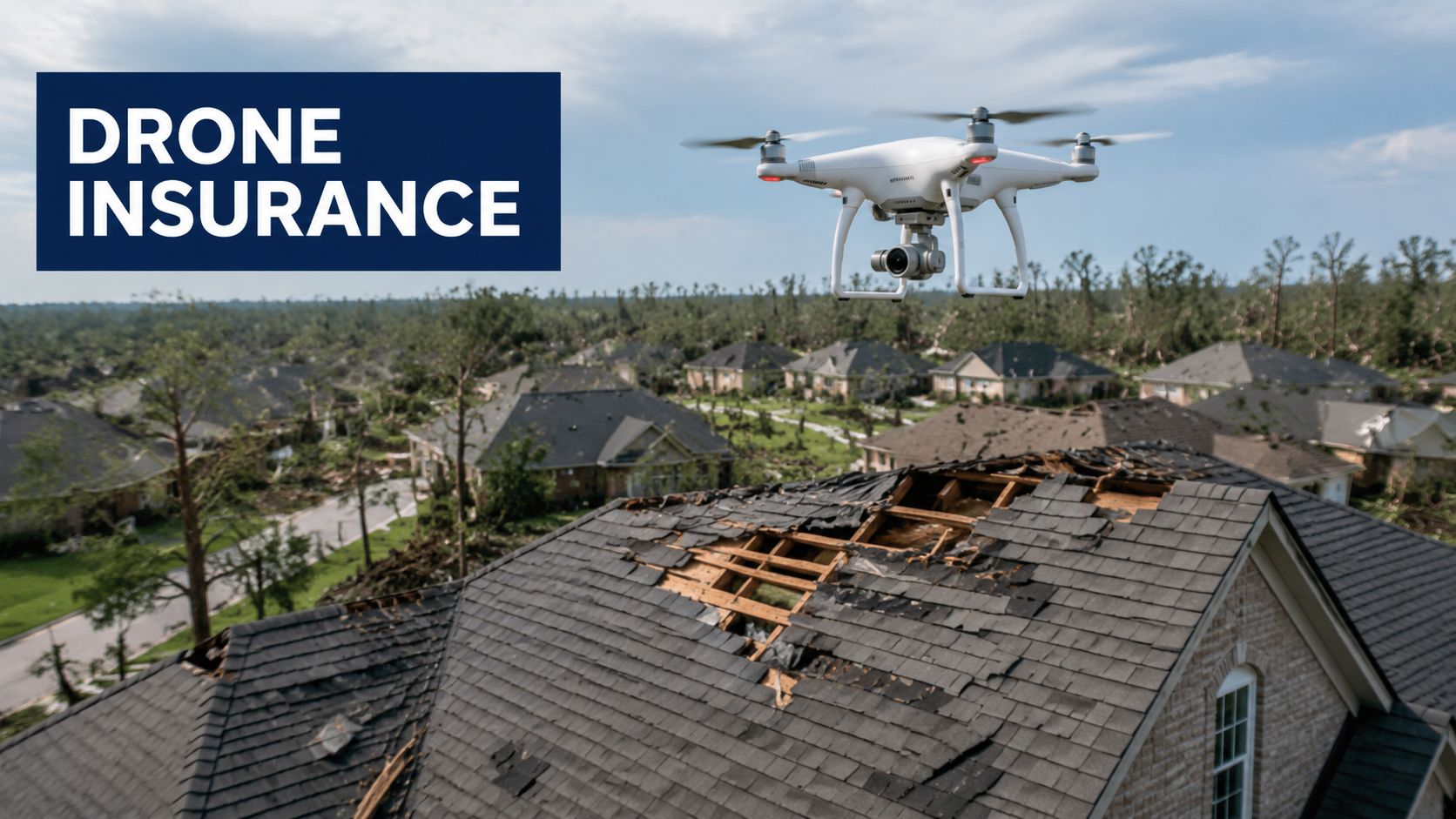
A storm has just pushed through regional Australia, and an insurer needs eyes on damaged roofs, fences, sheds, and access roads before the next wave of claims arrives. A drone can get airborne quickly, capture usable evidence from a safe distance, and give the claims team a clearer first look than a ground inspection can usually provide.
That is why drones in insurance have moved into ordinary commercial practice. They support claims triage, underwriting, catastrophe response, and site documentation, while also creating new questions about compliance, liability, and who carries the risk when the aircraft itself causes a problem. In Australia, those questions matter because the operating environment is shaped by CASA oversight, licensing, and insurance expectations that sit around the flight, not just the claim outcome.
Table of Contents
- Introduction and core concepts
- Key use cases for drones in insurance
- Pilot qualifications and compliance requirements
- Recommended equipment and data collection methods
- Workflow design and data management best practices
- ROI cost benefits and addressing risk
- Implementation roadmap case studies and conclusion
- FAQ
Introduction and core concepts
Why drones fit insurance workflows
A claim lands after a storm, and the first decision is about triage. The insurer needs to know what can be assessed remotely, what needs a site visit, and what needs urgent escalation because the property is unsafe or inaccessible.
A drone changes that first look. In insurance, it is more than a flying camera. It is a field data tool that can support live aerial imagery, mapping, and post-processing into structured evidence. Australian commentary has already treated drone deployment as practical in claim workflows because a drone can be sent to inspect a loss site soon after notification, which shortens the gap between claim intake and first-look assessment. Insurance Business Australia reported that this use was being discussed alongside global estimates that drones could save the insurance industry nearly US$7 billion per year, cut settlement time from days to hours, and improve inspection efficiency by up to 85% in some contexts (Insurance Business Australia).
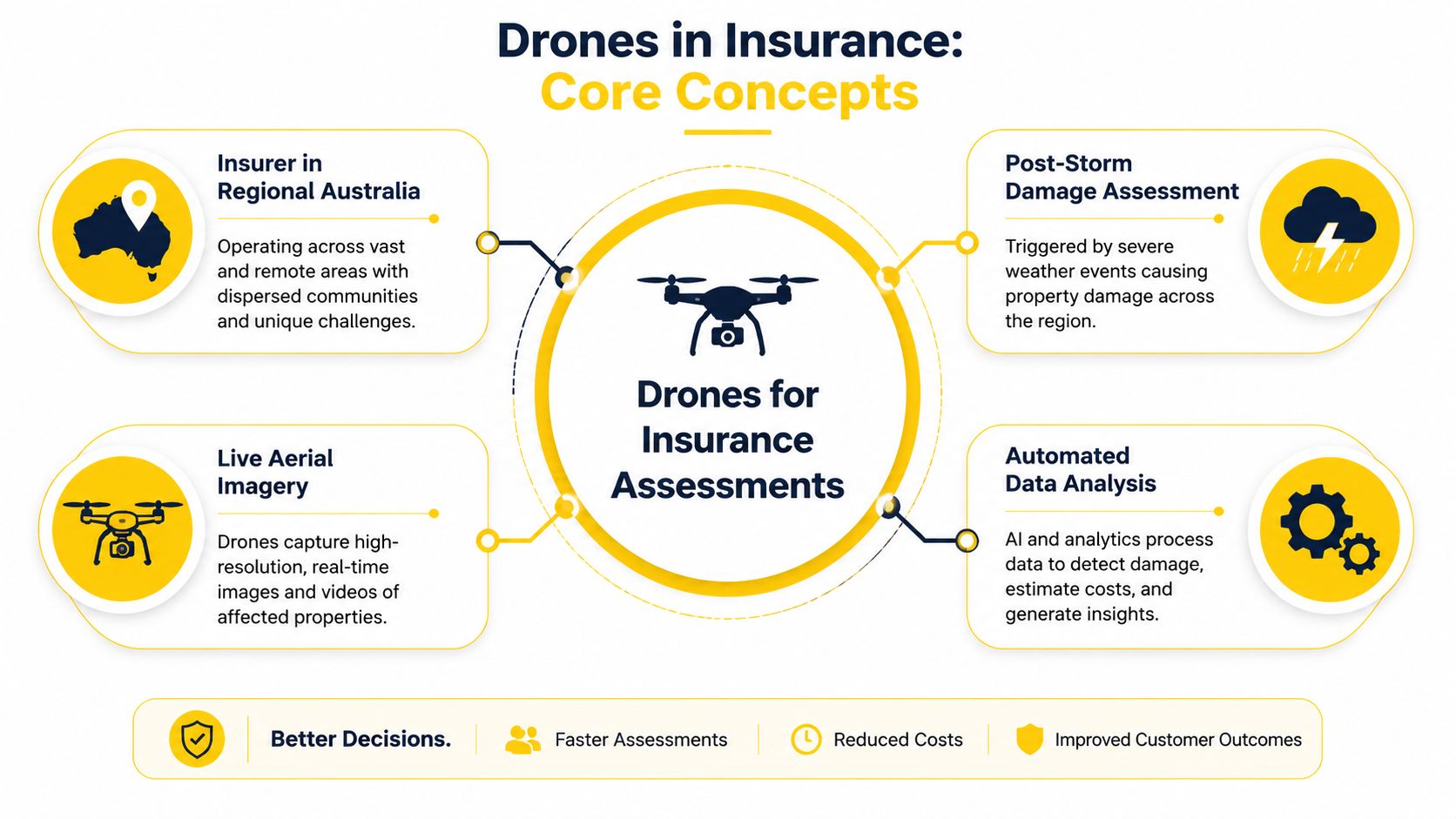
In Australia, the appeal is practical. Long travel distances, remote assets, and weather-exposed property portfolios make aerial assessment especially useful after storms, bushfires, and floods. A claim that would otherwise wait for a field visit can often begin with a remote look at the roofline, the access route, the surrounding hazard environment, and any immediate safety issues.
The wider market context matters too. For a useful overview of how drones sit inside the local commercial ecosystem, the drone work and Australian drone ecosystem overview explains the sector in practical terms. For agencies and risk teams, the main lesson is simple. Drones reduce the distance between event and evidence. A good guide to drone insurance for agencies can help frame the liability questions.
Core terms used in drone-assisted claims
The insurance side of drone work uses a few terms that often get mixed together. RPAS means remotely piloted aircraft system. Photogrammetry is the process of turning overlapping images into measurable maps or models. Aerial inspection is the broader task of using the aircraft to document damage, risk, or site conditions.
That difference matters because a drone flight can be used in more than one way. A claims team might only need high-resolution photos of a roof. An underwriting team might need a wider site survey showing vegetation, slopes, drainage paths, nearby structures, or access constraints. Gen Re notes that drones let insurers factor in contextual variables such as neighbouring facilities, bodies of water, slopes, vegetation, excavations, and access routes, which supports faster claims processing and safer assessment of fire and natural-hazard losses without sending adjusters into hazardous areas (Gen Re).
Practical rule: the aircraft is only part of the job. The value comes from matching the flight purpose to the question the insurer needs answered.
A professional workflow usually starts with one of three questions. What was damaged? What caused the damage? What can be safely verified from above? Once those questions are clear, the drone task becomes easier to design, document, and defend.
Key use cases for drones in insurance
Claims, underwriting, catastrophe response and fraud checks
A drone in an insurance workflow usually answers one of four questions. What is damaged? What risk sits around the asset? Where do urgent claims need attention first? Does the imagery support the story being presented? Claims inspection is the most obvious use, because a drone can document visible damage without asking an adjuster to climb onto a roof or walk through a flood-affected site. Underwriting uses the same imagery to understand risk before a policy is written or renewed. Catastrophe response focuses on speed, especially after severe weather when many properties need attention at once. Fraud and anomaly checks rely on image consistency, site context, and repeatability rather than guesswork.
Australian conditions shape each of those uses in different ways. A wildfire-affected property in Victoria may need perimeter images, roof condition, and surrounding vegetation context. A Queensland flood claim may depend on access routes, debris fields, and how water has interacted with the site. A New South Wales roof inspection may be straightforward from above but still reveal clues about hail impact, broken flashing, or maintenance issues that existed before the event. That is why a good drone program starts with the question the insurer needs answered, not with the aircraft itself.
Aerial capture also has a commercial side. Insurers that build repeatable drone services often find new work across claims, underwriting, and risk review, which is why many operators watch the business case closely, including the growth angle discussed in this drone business opportunity overview. The practical point is simple. A drone program is easier to justify when it reduces site delays, shortens decision time, and gives the insurer a clearer record of what was seen.
The economic case has already been described by Insurance Business Australia through Deloitte's estimate. It said drones could save the insurance industry nearly US$7 billion per year, cut settlement time from days to hours, and improve inspection efficiency by up to 85%. The exact result for an Australian insurer will still depend on claim mix, geography, and compliance overhead, but the direction is clear. Faster capture usually means faster triage, and faster triage usually means fewer files sitting idle.
A good way to sort the use cases is by decision type.
| Use case | What the drone helps answer | Typical Australian scenario |
|---|---|---|
| Claims inspection | What is visibly damaged? | Roof or storm damage in suburban or regional property claims |
| Underwriting | What does the surrounding risk look like? | Vegetation, access, drainage, or site exposure |
| Catastrophe response | Where should adjusters go first? | Post-storm surge in Queensland or bushfire response in Victoria |
| Fraud checks | Does the imagery match the story? | Claims where timing, access, or damage pattern needs review |
The value is not only speed. It is consistency. Two adjusters can disagree about a site visit. A flight record creates a repeatable reference point that can be reviewed later, compared with earlier imagery, and explained to a claims manager or underwriter.
Where teams first see the benefit is usually triage. Claims teams get a fast first look, so they can separate urgent files from routine ones. That reduces unnecessary travel, which matters in Australia where one claim site can sit a long way from the nearest office or contractor.
Underwriting is the next obvious gain. Aerial imagery lets an insurer see what surrounds the insured asset instead of looking only at the building envelope. That makes it easier to understand access risk, hazard exposure, and maintenance issues that may be missed in a desk review. For teams comparing training pathways, TruTec's Part 107 study guide is one example of the kind of structured preparation that helps pilots understand how disciplined aerial work is built, even though Australian commercial operations still need to be framed around CASA requirements.
A drone program works best when the insurer knows which decisions it wants to speed up, not when it buys aircraft alone and hopes the process improves.
Pilot qualifications and compliance requirements
RePL, ReOC and AROC in plain English
Commercial drone work in insurance sits inside CASA's regulatory framework, so the first question is who is flying and under what authority. For an individual pilot, the main credential is the Remote Pilot Licence (RePL). For the organisation, the key approval is the Remote Operator Certificate (ReOC). Finder's Australia-focused guide says commercial operators must hold a RePL and, where relevant, an ReOC to show competence, and it also notes that public liability cover for drone operations can reach $20 million (Finder).
That licensing structure matters because insurers are not just buying imagery. They are buying a process that can stand up to review after a loss event. CASA's commercial-drone guidance, as summarised in legal insurance commentary, recommends third-party public liability insurance and first-party property insurance, also described as UAV insurance, for commercial operators (Conventus Law).
An AROC, or Aeronautical Radio Operator Certificate, becomes relevant where radio communication is needed, especially in controlled airspace or more complex operational environments. It is not a generic box-tick. It supports safer coordination when the mission intersects with other aircraft traffic or formal airspace procedures.
For readers comparing Australian and overseas training references, a useful non-local study aid is TruTec's Part 107 study guide, which helps frame the broader idea of commercial drone compliance, even though Australian rules come from CASA rather than the FAA.
What insurers want to see before authorising a flight
Compliance is not only about holding the right licence. It is about showing that the flight was planned properly. CASA guidance, as summarised in an Australian insurance review, expects operators to stay within permitted altitudes and locations, and it strongly recommends public liability and UAV hull insurance as part of documented operational controls (Ensure Recruitment).
That matters for insurer and operator risk sharing. A claim inspection flight often happens after a damaging event, so the operator is exposed to both operational risk and claims-related liability. A well-run workflow usually includes pilot qualification checks, organisational authority checks, airspace and site checks, insurance checks, and mission records that show who flew, what was captured, and how the files were stored.
The Australian market also expects proof of competence before access is granted. One industry guide notes that many clients require public liability proof before allowing drone operations on site, with commercial cover often set at AUD $10 million to $20 million (mmoww). That is a practical reminder that a compliant flight plan often starts with the paperwork, not the aircraft.
For organisations building a formal program, Ace Aviation Aerospace Academy's guide to ReOC in Australia is a useful internal reference for understanding how organisational approval fits into commercial drone operations.
Recommended equipment and data collection methods
Choosing the right platform and sensor
A storm-damaged roof and a spread-out rural property call for different aircraft. A multirotor suits rooflines, façades, and short inspection runs because it can hover, turn tightly, and work in confined spaces. A fixed-wing aircraft suits longer routes and broader area coverage, especially for large rural blocks, linear assets, or wide catastrophe mapping.
Sensor choice shapes the quality of the record. High-resolution RGB imaging is the main tool for most claims work because it shows visible damage clearly. LiDAR adds terrain and structural depth, which helps when the insurer needs three-dimensional surface detail or ground context. Thermal imaging has a narrower role, since it is useful where heat signatures matter, but it still needs careful interpretation and a clear reason for use.
Stable, repeatable imagery is easier to assess later. A good inspection setup normally includes a stabilised gimbal, careful flight planning, and, where conditions require it, ND filters to control glare and shutter speed. Redundant navigation and sensor checks also matter, because insurance missions often happen under time pressure after weather events or during busy operational windows.
Equipment choice should match the job, not the other way around. A specialised platform such as the XAG P150 Max Australian agriculture application guide is a useful example of how purpose-built drones can be configured for demanding field work, even when the end use sits outside insurance. The lesson transfers directly to claims and underwriting teams, which need a platform that fits the inspection task, the site conditions, and the reporting standard.
For operators comparing training pathways against operational needs, Ace Aviation Aerospace Academy's enterprise drone business and operations package is one route that combines pilot certification and organisational preparation in a single structure. It is relevant where a team needs both flight skill and the compliance architecture around it.
| Platform or sensor | Best fit | Main limitation |
|---|---|---|
| Multirotor | Roofs, façades, tight sites | Shorter range |
| Fixed-wing | Large-area coverage | Less suited to hovering |
| RGB camera | Visible damage and documentation | Limited depth information |
| LiDAR | Terrain and 3D measurement | More specialised processing |
What counts as insurance-grade evidence
Drones give insurers high-resolution aerial data that expands the view from the damaged asset to the surrounding hazard environment. Factors like slopes, vegetation, and access routes help analysts judge causation and severity more accurately, so the evidence package should support more than a visual check. The file set needs to be structured enough to support a later decision, not just a first look at the scene.
Three things matter most.
- Resolution, because the image must be sharp enough to show condition, not just shape.
- Positioning, because the asset and its surroundings need to be located accurately.
- Consistency, because repeated inspections should be comparable over time.
If the drone captures only the damage and not the context, the claim file can still be incomplete.
Insurance teams often work with file types such as GeoTIFF for mapped imagery and LAS for point cloud data because those formats preserve spatial value. The format alone does not make a file defensible, but it does make review and handover easier. The operator should think about the evidence trail before take-off, not after the upload.
The file handling side matters too. For teams trying to streamline approvals, streamlining document management can help keep imagery, logs, and supporting records organised in one workflow.
Workflow design and data management best practices
A repeatable mission process
A drone claim workflow should be run like a controlled inspection sequence, not a one-off flight. Each mission follows the same steps, and only the site details change. That consistency matters because insurers need to compare files across claims, operators, and regions without wondering whether the process changed halfway through.
A practical workflow usually moves through five stages.
- Pre-flight planning and risk assessment. Confirm the site, hazard conditions, airspace, and the purpose of the flight.
- Mission execution. Capture the images or video needed for the claim or underwriting task.
- Data upload and processing. Transfer the files into the insurer's workflow or mapping platform.
- Flight logs and metadata tagging. Record who flew, where, when, and under what authority.
- Datum settings and secure cloud storage. Keep the geospatial settings consistent and the files protected.
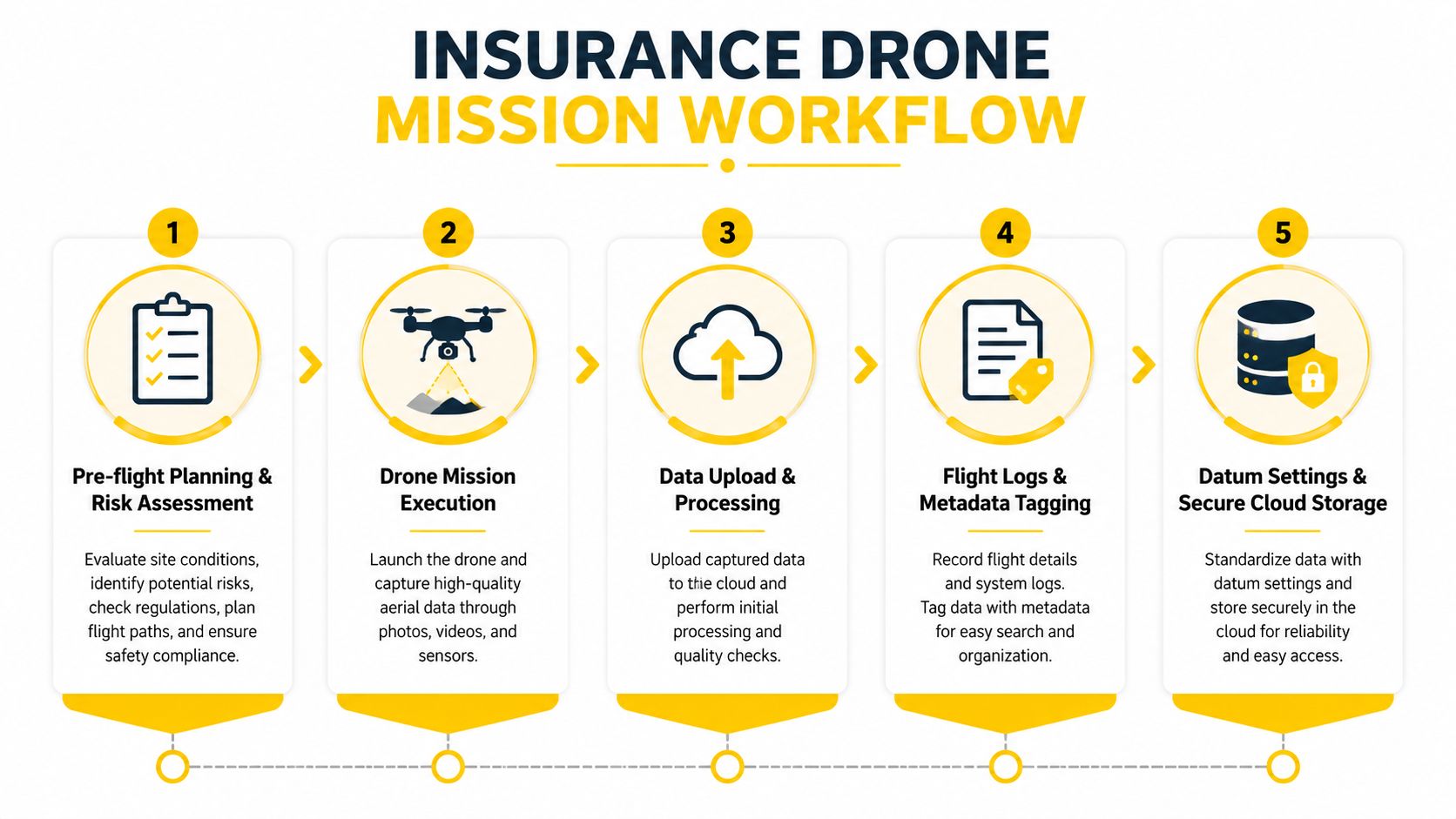
The same sequence also helps when drone outputs feed claims systems or GIS tools. If one operator labels files by suburb, another by claim number, and a third by date only, the evidence trail becomes hard to follow. A standard workflow reduces that confusion before it reaches the claims desk.
For teams trying to streamline files and approvals, streamlining document management is a useful reference for intake, tagging, and retention. The insurance use case has its own operational requirements, but the basic idea is the same. Information should move through one clear path, with every handoff visible.
Keeping data defensible and secure
Recordkeeping is part of the evidence, not an admin task after the fact. CASA expectations, including flying within permitted altitudes and locations, sit beside the insurer's need for documented controls and appropriate insurance cover. A workflow that ignores either side creates avoidable risk. If the flight is lawful but the file cannot be traced, the claim support weakens. If the file is neat but the flight was not properly authorised, the insurer still has a problem.
A strong data process usually includes:
- Flight logs, with time, location, and operator recorded clearly.
- Metadata tagging, so files can be linked to the correct claim or property.
- Datum settings, so every map or model uses the same spatial reference.
- Access controls, so only authorised staff can edit or move files.
- Retention rules, so records are kept long enough for dispute handling and audit.
Chain of custody matters because an image set that cannot be traced back to a flight is weaker in a dispute. For operators who want a practical guide to what can go wrong in field operations, the drone pilot emergency handbook for ANCA, CANCA, and ATSB requirements is a useful reminder that flight planning, incident response, and documentation need to work together. A well-run process does not need to be complicated, but it does need to be consistent. That consistency is what turns a drone recording into insurance evidence.
ROI cost benefits and addressing risk
Where savings come from
A drone program usually makes the most sense where travel, time, and safety exposure already sit high. A claims team can inspect from above instead of sending staff onto unstable roofs, into floodwater, or across long rural distances. That can reduce labour spent on low-value site visits and speed up the first decision on a file.
The commercial case is supported by the broader industry estimate noted earlier. Drones have been described as having the potential to save the insurance industry nearly US$7 billion per year and improve inspection efficiency by up to 85%. Even so, Australian insurers still need to budget for compliance, training, equipment, software, and post-processing. A drone program is not free merely because the aircraft is small.
The value is uneven across claim types. Drones are strongest when the task is hard to access, time-sensitive, or repetitive. They may be less useful for dense urban claims where launch and privacy constraints are harder to manage, or in severe weather where the aircraft cannot safely complete the mission.
Commercial rule: if the site is too risky for a person to access quickly, ask whether a drone can safely do the first assessment.
For operators building their own safety procedures, Ace Aviation Aerospace Academy's emergency-handbook resource is a practical reminder that flight planning, incident response, and documentation need to work together.
The risk-transfer gap operators still miss
A major unresolved issue is who pays when a drone is used in an insurance workflow and something goes wrong. Australian government research identified that as an underserved question, especially around public liability, hull and professional indemnity exposure (Australian Government drone uptake report). That gap matters because a drone used to help process a claim can still create a separate loss if it crashes, damages property, or triggers privacy complaints.
Insurance teams should separate three exposures.
- Public liability, for third-party injury or property damage.
- Hull insurance, for damage to the drone itself.
- Professional indemnity, where advice, reporting, or workflow errors create financial loss.
A simple way to review the gap is to ask who is responsible at each stage. The pilot may be compliant with CASA requirements, the insurer may still carry workflow risk, and a contractor may need different cover again if the arrangement changes the duty of care. That is why drone programs need to be checked like any other operational control, not treated as a generic technology purchase.
Australian commentary also shows the market moving towards purpose-built cover, with dedicated drone products emerging as commercial demand grows. The key point is not that every program needs the same policy. It is that the policy structure should match the mission profile, especially when the operator is flying on behalf of an insurer or a client.
Implementation roadmap case studies and conclusion
Regional catastrophe response
A regional insurer in northern Queensland faces a post-storm surge. Roads are patched, some properties are still inaccessible, and the claims team needs to separate urgent files from routine ones. The first move is not to send everyone out. It is to build a small drone workflow that can triage the worst-affected sites.
The team starts with training. One pilot completes RePL training, and the organisation builds its operating structure around ReOC requirements. The reason is practical, not ceremonial. A trained pilot can conduct repeatable flights, and the organisational approval gives the insurer a way to document control, oversight, and responsibility.
A trial flight is then used to test roof capture, access, and file naming. The claims team checks whether the imagery is clear enough for first-look assessment and whether the captured context helps identify safety issues. Once the process works, the drone is deployed after future events to document the site quickly, while adjusters decide whether a physical visit is necessary.
Urban property underwriting
A metropolitan insurer wants better visibility on properties that are harder to assess from the street. The use case is not catastrophe response. It is routine underwriting and renewal review. The team needs to understand roof condition, site access, nearby hazards, and whether the current file matches what is visible on the ground.
The workflow begins with small-scale pilot flights, then moves to regular use once the data quality is stable. The team learns very quickly that aerial imagery alone is not enough. It must be paired with records, site notes, and decision rules so that the imagery informs the underwriter rather than replacing judgement.
For some teams, a structured training path helps more than ad hoc learning. Ace Aviation Aerospace Academy offers RePL, AROC, and ReOC consulting services, which fit organisations that need both pilot capability and the governance layer around it. That is relevant where drone use is moving from experiment to normal operating procedure.
A practical rollout timeline
A workable rollout does not start with buying drones. It starts with defining the need, the site types, and the claims or underwriting decisions the imagery will support.
| Phase | What happens |
|---|---|
| Needs analysis | Define the claim types, sites, and risk problems that drone data should solve |
| Pilot recruitment | Identify who will fly and who will oversee the process |
| Compliance setup | Align operating procedures with CASA and insurance requirements |
| Pilot training | Complete RePL, AROC, and any organisational training needed |
| Equipment procurement | Choose aircraft, sensors, batteries, and storage tools |
| Pilot operations | Run limited flights on real files and test the workflow |
| Data review | Check image quality, metadata, and file handling |
| Scale-up | Expand to more sites, more claims, or broader underwriting use |
The important lesson is that implementation works when the insurer treats drones as part of an evidence system. The aircraft, the pilot, the insurer, and the claim file all need to fit together.
FAQ
When is a drone inspection inadvisable?
A drone inspection is inadvisable when weather, access, privacy, or site restrictions make the flight unsafe or non-compliant. It is also a poor choice when the claim needs close physical testing rather than aerial documentation.
What insurance certificates do land managers usually want to see?
Land managers commonly want proof of public liability insurance before they grant operating permission. In commercial settings, they may also ask for evidence that the operator's insurance matches the task and the site risk.
How long does it take to get a RePL and AROC?
The timing depends on training provider scheduling, learner readiness, and assessment completion. A structured provider can help a pilot prepare for both qualifications in a planned sequence.
What data security measures protect client privacy?
Strong privacy controls usually include access permissions, encrypted storage, metadata discipline, and clear retention rules. Files should be stored so that only authorised staff can view or edit them.
Where can a business get help setting up a compliant drone program?
Australian operators often start with RePL training, AROC support, and ReOC consulting so the workflow is built around CASA compliance from the outset. That approach suits businesses that want the flight process, records, and governance to work together.
A CTA for Ace Aviation Aerospace Academy.
