

A commercial drone job can look straightforward at briefing time, then fall apart at the map check. A pilot may be lining up a roof inspection, a farm survey, or a transport corridor flight, only to find the site sits inside restricted airspace, near a runway approach, or under a local access rule that wasn't obvious from the street. That's why drone no fly areas matter so much in Australia, they sit at the point where safety, legality, and commercial planning all collide.
Australian drone no-fly areas are shaped by state and national security restrictions and CASA's geo-awareness framework, supporting hundreds of thousands of registered operators across regulated controlled and prohibited airspace. If a business treats the map as the only check, it can miss the full compliance picture. For a broader legal overview, readers often start with Ace Aviation Aerospace Academy's guide to drone laws in Australia 2026, then work down into the airspace details that affect every commercial flight.
Table of Contents
- Introduction to Drone No Fly Areas
- Understanding CASA No Fly Regulations
- Identifying No Fly Areas with Official Tools
- Obtaining Permits and Exemptions for Restricted Zones
- Penalties and Enforcement for Breaching No Fly Areas
- Best Practice Compliance Guidance for Commercial Operators
- Conclusion and Key Takeaways
- Frequently Asked Questions
- How can a pilot check temporary flight restrictions before a job?
- When should a business seek a CASA-related exemption or authorisation?
- What's the difference between public land and private land permissions?
- Do recreational drone rules still matter near restricted zones?
- Is a visible geofence enough to prove a site is safe to fly?
Introduction to Drone No Fly Areas
A survey pilot can arrive early, unpack the drone, and still have to cancel the flight. The reason might be a nearby aerodrome buffer, a controlled airspace boundary, or a site rule that blocks launch and landing even though the sky overhead looks open. That's the everyday reality behind drone no fly areas, the safest jobs are the ones that are cleared before the propellers ever spin.
CASA's framework matters because airport-adjacent airspace is one of the strictest parts of the operating environment. The general exclusion around aerodromes, plus controlled and prohibited spaces, means a commercial operator can't rely on guesswork or “common sense” alone.
Practical rule: if the flight plan hasn't been checked against the airspace map and the site permissions, it hasn't really been planned.
Commercial teams also get caught by the difference between what's allowed in the air and what's allowed on the ground. A site can be outside a marked flight restriction and still be off-limits because of landholder consent, privacy, or a temporary local condition.
That's why competent operators check the airspace, then check the site, then check the mission. Those three layers keep a simple job from turning into an enforcement issue.
Understanding CASA No Fly Regulations
A drone job can look straightforward on the ground and still fall apart the moment a pilot checks the rules. The strip of air above a site may be open, while the ground below is tied up by privacy concerns, landholder consent, or a local condition that blocks take-off and landing. CASA's rules make more sense when you separate those layers, because each one protects something different.
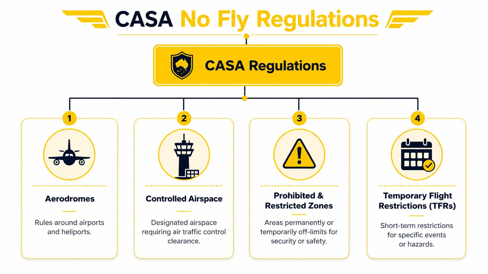
The main CASA categories
- Aerodromes: CASA applies a general 5.5 km exclusion around aerodromes. From 5.5 km to 3 nautical miles from a runway threshold, drones may only fly up to 400 ft and not above aerodrome traffic circuit height. Within 3 nautical miles of a runway threshold, they must stay below 400 ft and not over runway approach or departure paths. This keeps small aircraft and drones from sharing the same space at the wrong time, which is why the boundaries deserve careful checking. CASA aerodrome buffer reference
- Controlled airspace: Drones must not fly there without authorisation. Urban jobs and work near transport corridors often run into this category first, even when the site itself appears ordinary.
- Prohibited and restricted zones: These areas can be permanent or temporary, and they are often tied to security or safety needs.
- Temporary flight restrictions: These short-term limits can appear for incidents, events, or hazards. They change the picture quickly, so a clearance that worked yesterday may no longer apply today.
Comparison of Restricted Airspace Categories
| Airspace Type | Definition | Flight Rules |
|---|---|---|
| Aerodromes | Airport and heliport protection areas | Follow the 5.5 km exclusion, stay below 400 ft, and avoid runway approach and departure paths. |
| Controlled Airspace | Designated airspace managed for aircraft separation | Drone flight needs prior authorisation. |
| Prohibited & Restricted Zones | Security or safety areas that are off-limits permanently or conditionally | Do not enter unless the relevant authority has authorised the operation. |
| Temporary Flight Restrictions | Time-limited restrictions for specific events or hazards | Check immediately before flight, because the status can change quickly. |
For pilots who work in property, inspections, or marketing, a useful parallel is the way real estate drone laws treat the space above a site differently from the rights to launch, land, and capture imagery on the ground. The airspace question is only one layer of the legal review, and site access rules can matter just as much.
For operators building their skills from scratch, ACE READY is an entry-level drone training course for beginners that covers drone fundamentals, aviation safety, CASA regulations, flight operations, and preparation for advanced RePL training in Australia. It fits naturally for students who need the basics before handling more complex airspace decisions. If the operation involves excluded category work, the next checkpoint is Ace Aviation Aerospace Academy's guidance on excluded category drone operations.
Identifying No Fly Areas with Official Tools
A pilot can have a clean map and still be wrong at the gate. Drone no fly areas need a layered check, because the airspace rules, the app data, and the site access rules each answer a different question. The map tells you where flight is restricted. The landholder tells you whether you may launch or land. Privacy and image use sit alongside both, especially for commercial work over homes, worksites, or public-facing locations.
A simple pre-flight workflow
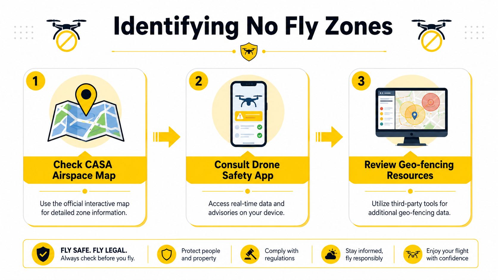
- Check the CASA airspace map. Enter the planned coordinates and read the zone overlays before any flight brief starts. The map shows controlled airspace, aerodrome buffers, and other published restrictions to the operator.
- Use the official approved drone safety app list. CASA provides the current app guidance, and the pilot still needs to treat the app as a live check, not a one-time download. The app helps confirm controlled airspace and temporary restrictions before every flight. Drone Safety App guidance
- Review extra geo-fencing resources. Third-party tools can support the official check, but they should never replace it. A backup layer is useful, yet the final call still rests on the official source and the current mission details.
That sequence matters because a screenshot can age quickly. A tile that looked clear earlier in the day may miss a temporary restriction, a local event zone, or a ground-level condition that stops a lawful take-off or landing.
A good pre-flight habit is simple, repeatable, and a little repetitive. Check the map, check the app, then compare the result with the site plan before the aircraft leaves the case.
Common pitfalls that catch experienced crews
- Outdated device data: A cached map can lag behind live restrictions.
- Missed temporary alerts: A flight that was legal in the morning may not be legal later in the day.
- Overreliance on one platform: Automated overlays are useful, but they are not a substitute for a documented pre-flight check.
- Confusing airspace with site access: A clear flight path does not automatically mean the landholder has approved take-off or landing.
Crews who are still learning the process need structure before they start repeatable commercial workflows. General training is the right place to build that base, because it helps pilots read airspace, understand flight safety, and recognise the difference between permission to fly and permission to use the site.
For airport or heliport work, Ace Aviation Aerospace Academy's safety guide for airports and heliports is a useful companion to the map check. It keeps attention on where aircraft move, not only on where the icons sit on the screen.
Obtaining Permits and Exemptions for Restricted Zones
A flight plan can reach a point where the answer is still possible, but only after the right approvals are in place. That usually means stopping to identify whether the problem is airspace, operational control, or simple site access before a drone leaves the ground.
For commercial operations, individual pilots need a Remote Pilot Licence (RePL), and organisations must hold a Remote Operator's Certificate (ReOC) before they can authorise work in controlled or prohibited areas. The relevant CASA guidance on licence and authorisation requirements should be checked against the specific job, because a capable pilot still needs the right organisational setup. A pilot cannot fix a missing approval by promising careful flying.
Permit and exemption pathways
| Permit type | Who handles it | Who usually needs it | What it does |
|---|---|---|---|
| RePL | Individual pilot pathway | Commercial pilots | Supports commercial flying within the specified weight categories. |
| ReOC | Organisation approval | Businesses and operators | Lets a company authorise flights, manage procedures, and control compliance systems. |
| Airspace authorisation | Relevant aviation authority process | Operators near controlled or restricted areas | Allows a flight that would otherwise be off-limits. |
| Site-specific exemption or approval | Relevant authority or landholder, depending on the issue | Operators facing ground or mission constraints | Deals with access, permission, or special operational conditions. |
The first question is usually plain enough, even if the paperwork is not. Is the restriction coming from controlled airspace, from the operator's internal compliance setup, or from the property itself. A ReOC helps with the company side of commercial RPAS work, but it does not cancel every ground rule at the launch point. A farm, a warehouse, or a council asset may still require separate consent before take-off or landing can begin, and that same issue can show up in privacy rules or landholder permission even when the map looks clear.
For teams that need the next training or licensing step set out clearly, Ace Aviation Aerospace Academy's licence finder can help identify the right pathway before an application file starts to grow. In more complex cases, a ReOC consultant or enterprise training provider can be useful because the approval burden often sits in procedures, not just in forms.
Penalties and Enforcement for Breaching No Fly Areas
A breach near a runway buffer is not treated like a casual planning mistake. The closer the flight is to aerodrome protection space, the more likely it is to trigger scrutiny, because the risk to manned aircraft is immediate and obvious. Even a small height exceedance can create an incident report if it happens in the wrong place.
CASA's enforcement options can include notices, licence consequences, and court action where the breach justifies it. The practical impact is bigger than the paperwork itself, because an operator may lose time, contract confidence, and access to future work even before the legal process finishes.
What enforcement can look like
- Infringement action: Used when the breach is clear and the evidence is straightforward.
- Licence impact: A RePL holder can face consequences that affect future flying.
- Operational disruption: A business can lose a job, a client, or an approval pathway.
- Further investigation: Sites near aerodromes or in controlled airspace often receive extra attention because the safety margin is thin.
The lesson is simple. If the flight plan depends on “probably fine”, it isn't ready. Commercial operators need a documented reason to believe the airspace is clear and the site is lawful.
Best Practice Compliance Guidance for Commercial Operators
A flight can look clean on the map and still fail on the ground. Commercial operators need to check three separate layers before launch, the airspace, the site permissions, and the mission risk. That is the part many crews miss, because geofences only show part of the picture. They do not tell you whether you have landholder consent, whether the take-off point is allowed, or whether the flight could expose people's privacy.
A job can be lawful in the air and still be unlawful at the site. That happens when an operator treats the airspace check as the whole compliance check, then discovers the property owner, manager, or client has different access rules. Operational risk guidance is not the right reference for Australian operations, so a better habit is to rely on local guidance, including CASA's operational rules and safety guidance, and to verify the site requirements before wheels-up. For operators doing drone aerial mapping, that step matters even more because a mapping run often needs repeated passes, a clear launch area, and permission to capture data across more than one part of a property.
A practical compliance roadmap
- Check the airspace first. Confirm controlled areas, aerodrome buffers, and temporary restrictions before mobilisation.
- Confirm site permission separately. Private land, public land, and managed assets can all carry different access rules.
- Brief the client or landholder. The launch point, capture area, and recovery area should all be understood in advance.
- Document the risk controls. Keep records of the airspace check, operational plan, and any special conditions.
- Refresh skills regularly. Rules, apps, and operating habits change, so refresher training matters.
For teams building a more formal system, Ace Aviation Aerospace Academy's ReOC consulting guide is a practical resource alongside structured training such as Remote Pilot Licence (RePL), Aeronautical Radio Operator Certificate (AROC), Certificate III in Aviation, Enterprise Drone Training, and Corporate Drone Training. Those options help a business build staff who can read the rules, use radio procedures correctly, and follow a repeatable compliance process.
A good operating culture does not assume that clear weather means clear approval. It checks the airspace, confirms the site, and keeps the paperwork in a condition that can stand up to review.
Conclusion and Key Takeaways
Drone no fly areas in Australia are not just airport circles on a map. They include aerodrome buffers, controlled airspace, prohibited and restricted zones, and temporary restrictions, and they're only part of the picture because land access, privacy, and mission risk still matter.
The safest commercial workflow is consistent. Check the official tools, confirm the right authorisation path, and keep written proof of the planning decisions. For operators serious about professional work, structured training such as RePL and Certificate III in Aviation helps turn compliance from guesswork into habit.
Frequently Asked Questions
How can a pilot check temporary flight restrictions before a job?
The flight should be checked immediately before launch using the official airspace and app-based tools, not from an old planning note. Temporary restrictions can appear quickly and change the legality of a flight after the site has already been briefed.
When should a business seek a CASA-related exemption or authorisation?
A business should seek approval when the flight falls inside controlled or otherwise restricted airspace, or when the operation needs a formal pathway that ordinary planning cannot cover. If the job involves repeat work in a sensitive area, the approval should be planned well before the first booking.
What's the difference between public land and private land permissions?
Public land usually involves rules from the managing authority, while private land depends on the landholder's consent. A pilot can have airspace clearance and still be unable to lawfully launch or land.
Do recreational drone rules still matter near restricted zones?
Yes, because the airspace restriction applies to the location, not just the type of flyer. Recreational operators still need to avoid restricted areas and follow the same basic checks that keep the flight legal.
Is a visible geofence enough to prove a site is safe to fly?
No, because a geofence only shows part of the compliance picture. A commercial operator still needs to check ground access, privacy, and the specific risk profile of the task.
Ace Aviation Aerospace Academy helps pilots and organisations build those checks into real operating practice through drone training, RePL pathways, AROC, and ReOC support. If this topic affects your next job, visit Ace Aviation Aerospace Academy to review the training and compliance options that fit your operation.
