

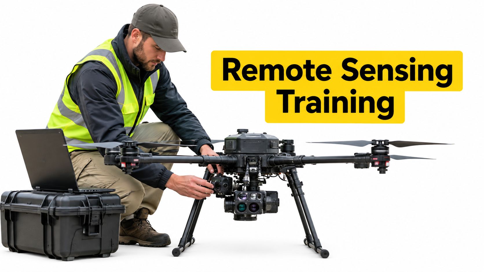
Remote sensing training in Australia covers both drone piloting and geospatial analysis, so imagery becomes a defensible, decision-ready output rather than a collection of attractive photographs. The nationally recognised CPP50221 Diploma of Spatial Information Services requires competency in 15 units, including 7 core units and 8 electives, and explicitly includes remotely sensed imagery, geospatial software, 3-D digital modelling and global navigation satellite systems (training.gov.au).
A commercial operator may return from a site with clear RGB images, full batteries and a neatly labelled project folder, only to discover that the client can't measure a boundary, compare crop conditions or defend an engineering decision from the data. The aircraft flew successfully, but the mission still failed to deliver operational value.
That gap defines professional remote sensing training. It connects CASA-compliant flight operations, sensor selection, calibration, photogrammetry, spatial data management, quality assurance and interpretation. The objective isn't just to capture more imagery. It's to produce information that surveyors, farmers, engineers, regulators and managers can understand and use.
Table of Contents
- What Remote Sensing Training Covers
- Sensor Types in Remote Sensing Training
- Course Structure and Skill Development
- Industry Applications and Career Pathways
- CASA Regulations and Safety Requirements
- Building Your Remote Sensing Career
What Remote Sensing Training Covers
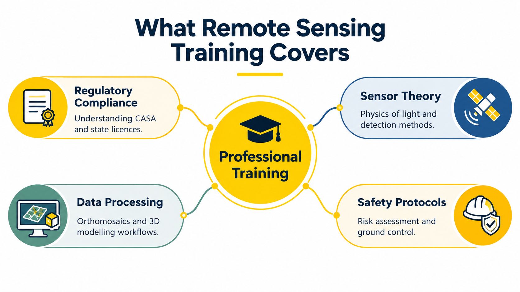
A crew can finish a clean, legal flight and still come back with data that does not support the job. That usually happens when training stops at image capture. Professional remote sensing training closes the gap between a successful sortie and a product a client can measure, compare, defend and use.
The starting point is the decision on the ground. An operator works backwards from that decision, much like an instructor planning a flight exercise from the required standard, not from the aircraft alone. If the task is asset recording, a visible-light camera may do the job. If the task is heat loss, plant stress or another condition that cannot be seen in ordinary colour, the sensor choice changes. CASA compliance sits inside that process, because legal airspace access, site assessment and safe operating limits shape what can be captured in the first place.
Training also shows how one choice affects the next. Flight height, ground speed, image overlap, illumination, wind and camera settings all influence whether the final output is reliable. A mission is therefore taught as a connected workflow. Sensor capability, operating conditions, processing method and reporting standard all have to line up.
From capture to a defensible product
Students need to learn what makes a result repeatable. In practice, that means recording the conditions and settings that explain why a map, model or index can be trusted, or where its limits sit. A sound field record can include:
- Mission settings: altitude, ground speed, camera settings and overlap.
- Environmental conditions: wind, illumination and irradiance conditions.
- Calibration evidence: calibration targets and sensor preparation.
- Positioning information: the georeferencing method and any ground control.
- Quality checks: checkpoints, known ground measurements and processing results.
A good training example uses real agricultural imagery rather than a perfect classroom dataset. The CSIRO agricultural dataset collection includes UAV RGB, thermal and multispectral captures, along with raw imagery and orthomosaics. It helps students see a practical trade-off. Lower flight heights can improve detail, but they also increase image volume and make the mission more sensitive to wind, illumination changes and motion blur.
One useful exercise is to fly or analyse the same plot at two altitudes. Students then compare ground sampling distance, orthomosaic completeness, classification outputs and the downstream effect on an agronomic decision. That is where the difference becomes clear. A map can look sharp and still be weak evidence.
The geospatial skills behind the aircraft
Remote sensing training also covers coordinate systems, metadata, GIS integration, uncertainty reporting and the habits needed to move from field capture to analysis. The CPP50221 Diploma of Spatial Information Services reflects that wider skill set, with competencies in remotely sensed imagery, geospatial software, modelling and positioning technologies (training.gov.au).
For many learners, aviation and geospatial skills need to develop together. A practical way to compare that mix is to review the Ace Aviation Aerospace Academy course catalogue alongside the diploma profile described above, especially where commercial drone operations must meet both flight and data standards.
Practical rule: A flight is complete only when the data has passed a documented quality check and can answer the client's operational question.
Sensor Types in Remote Sensing Training
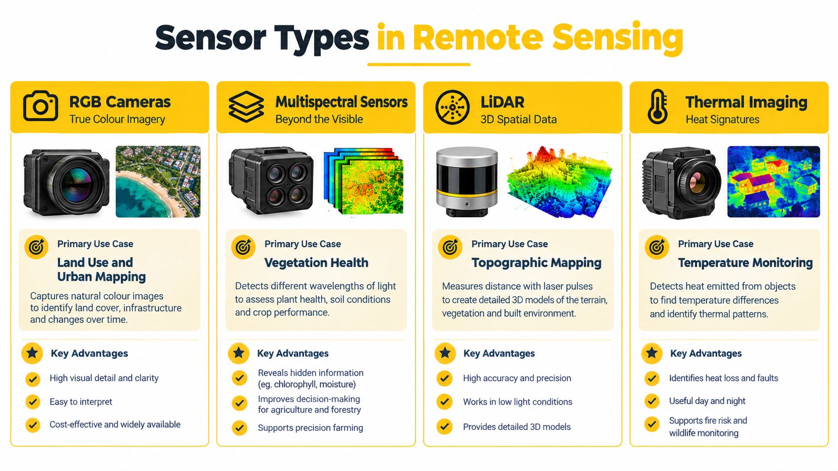
Sensor choice determines what a mission can reveal. A camera that records visible colour is useful for inspection and mapping, but it can't substitute for a sensor that measures thermal radiation or narrow spectral bands. Training should therefore compare each sensor's physical measurement, processing burden and appropriate use before discussing aircraft selection.
Matching the sensor to the question
RGB cameras record visible light. They support visual inspection, orthomosaic production, site documentation and photogrammetric modelling. Their outputs are familiar and often efficient to interpret, but they generally provide limited analytical information beyond visible appearance.
Multispectral sensors measure reflected energy across several discrete bands. Training commonly connects these data to vegetation health, crop stress, emergence, biomass and breeding-trial assessment. The operator must understand calibration, irradiance and the difference between a spectral index and a direct measurement of plant condition.
Hyperspectral systems capture hundreds of narrow spectral bands. That detail can help reveal chemical composition relevant to mineral exploration and environmental monitoring, but it increases data volume, calibration demands and analytical complexity. A hyperspectral mission needs a clear question and an appropriate processing workflow, not just a more advanced camera.
LiDAR uses laser pulses to generate three-dimensional point clouds. It can support terrain modelling, infrastructure analysis and work in areas where vegetation makes photogrammetric reconstruction difficult. Operators still need to understand point-cloud classification, positioning quality and the distinction between surface, terrain and structure.
Thermal sensors detect infrared radiation and can support search and rescue, building diagnostics and industrial inspections. Thermal interpretation depends on emissivity, environmental conditions, viewing geometry and the temperature contrast relevant to the task.
| Sensor Type | Data Captured | Primary Applications | Processing Complexity | Typical Flight Altitude |
|---|---|---|---|---|
| RGB camera | Visible-light images | Inspection, mapping and photogrammetry | Moderate | Mission-dependent |
| Multispectral sensor | Reflected energy across discrete bands | Vegetation health, crop stress and agronomy | Moderate to high | Mission-dependent |
| Hyperspectral sensor | Hundreds of narrow spectral bands | Mineral exploration and environmental monitoring | High | Mission-dependent |
| LiDAR | Laser-derived three-dimensional point clouds | Terrain, vegetation and infrastructure analysis | High | Mission-dependent |
| Thermal sensor | Infrared radiation and temperature patterns | Search and rescue, building and industrial inspection | Moderate to high | Mission-dependent |
The table deliberately avoids a universal altitude recommendation. Ground sampling distance, sensor optics, terrain, airspace, target size, required accuracy and aircraft limitations all influence the flight plan. A course focused on a particular platform, such as the XAG P150 course, should still teach the operator to justify mission parameters rather than copy a setting from another project.
For beginners, ACE READY is described as an entry-level drone training course covering drone fundamentals, aviation safety, CASA regulations, flight operations and preparation for advanced RePL training in Australia. It can establish aviation foundations, but sensor interpretation and spatial product validation require further development.
Course Structure and Skill Development
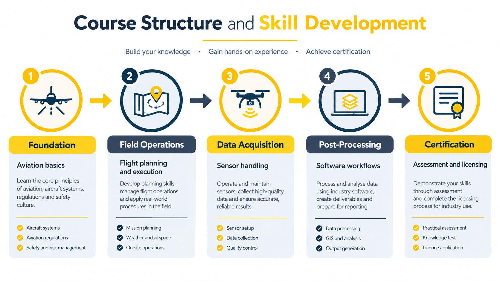
A good remote sensing course closes the gap between collecting images and producing something a client can use. For Australian commercial operators, that means learning two systems at once. One is the aircraft and its sensor. The other is the operational framework around CASA rules, risk controls, records, and proof that the final output is fit for purpose.
A progression from aviation to analysis
The sequence should start with aviation foundations, then build toward sensor-specific decision making. Students first learn airspace, weather, human factors, pre-flight planning, and safe aircraft handling. That base matters because a remote sensing mission can fail long before processing starts. If the aircraft is not flown predictably, overlap, height control, sensor angle, and timing all drift, and the dataset becomes harder to trust.
From there, training should connect the RePL-style flying syllabus to the actual stages of a sensing mission. Pre-flight work covers airspace checks, site hazards, battery planning, and emergency actions. In flight, the operator holds track, altitude, speed, and orientation tightly enough for the chosen sensor to do its job. After landing, the task shifts to data handling, because a well-flown mission still loses value if files, calibration records, or site notes are incomplete.
Students then move into acquisition and processing as one continuous workflow, not two separate subjects. They set sensor parameters, prepare calibration targets where needed, record environmental conditions, and organise field data so it can be traced later. Processing turns raw captures into orthomosaics, elevation models, point clouds, thermal outputs, or spectral products. The lesson is simple. The map or model is only as reliable as the planning and capture steps behind it.
Quality assurance is where many learners begin to understand professional remote sensing. Ground control, check points, coordinate systems, metadata, and error tracking are not paperwork added at the end. They are part of the measurement system itself. A course should also show how to explain limits clearly to a non-technical client, especially when weather, site access, lighting, or positioning quality affects confidence in the result.
A useful reference for shaping that learning sequence is this course curriculum development guide. It aligns well with practical assessment, where students are judged on whether they can complete an end-to-end mission and explain their choices.
What assessment should reveal
Assessment should make the student show how the whole chain fits together:
- A mission plan: the objective, selected sensor, airspace review, safety controls, and why the capture settings suit the job.
- A field record: flight parameters, calibration evidence, weather observations, and georeferencing method.
- A processed product: an orthomosaic, model, point cloud, or other mission output.
- A quality report: checkpoints, known measurements, limitations, and uncertainty.
- A client explanation: a plain-language summary of what the result supports, and where caution is needed.
The SmartSat CRC market study discussed earlier supports this broader approach. Employers need people who can process, analyse, communicate, and work within project requirements, not just fly the aircraft or click through software.
A pathway that supports those foundations may include the Certificate III in Aviation, especially for learners who need stronger operational discipline before moving into higher-value sensing work.
Industry Applications and Career Pathways
A farm manager, surveyor, and infrastructure inspector may all fly the same aircraft on the same day, yet they are not buying the same result. What matters in remote sensing training is the gap between image capture and operational value. Students need to learn how a sensor choice becomes a usable product, and how the job must still fit the operating rules that apply to commercial drone work in Australia.
Agriculture and land management
In agriculture, the aircraft is only the delivery platform. The key question is what the sensor can show, and whether the capture method makes that result comparable across time. RGB, thermal, and multispectral payloads can all support land management tasks, but each answers a different question about crop condition, variation, or change.
Training should therefore go beyond producing attractive maps. A capable operator records flight settings, calibration steps, environmental conditions, and georeferencing so the next mission can be matched properly. That is how imagery starts to support agronomic decisions rather than sitting in a folder as an isolated snapshot.
Surveying, construction and mining
Surveying and construction work make this distinction even clearer. A client may ask for a map, volume figure, or three-dimensional model, but the operator has to understand what makes that output defensible. Accuracy comes from the whole chain: control, positioning, image quality, processing choices, and validation. Missing one link weakens the result, much like a well-flown circuit still ends in a poor landing if the approach was unstable.
LiDAR may suit terrain or vegetation that limits image-based reconstruction. Photogrammetry may suit site mapping, progress records, as-built documentation, and earthworks measurement. In mining and environmental projects, multispectral or hyperspectral sensing may be more useful when material differences or environmental conditions matter. Training should help students recognise those fit-for-purpose choices early, before they promise a deliverable the sensor cannot support.
Infrastructure and emergency work
Thermal imaging can support building diagnostics, industrial inspection, and search and rescue. RGB mapping can contribute to asset records. Emergency tasks such as flood mapping or bushfire observation add another layer. Operators need disciplined records, clear task limits, and an understanding that some jobs also bring tighter operational approvals and competency expectations.
These application areas also point to different careers. Some roles focus on capture in the field. Others centre on processing, QA, GIS, surveying support, engineering interpretation, or client reporting. For a closer look at where that progression can lead, see this overview of drone pilot careers and the Certificate III in Aviation.
CASA Regulations and Safety Requirements
A remote sensing job can fail long before anyone opens the mapping software. The aircraft may capture sharp images, but if the flight was outside the correct approval pathway, in the wrong airspace, or without the required records, that dataset may have little operational value. Good training closes that gap by teaching operators to match sensor work with CASA rules from the first planning step.
Choosing the correct operating pathway
For commercial operators, the first question is not which camera to fly. It is which authorisation path fits the job. CASA RePL training covers aeronautical knowledge and practical competency, including a theory examination and flight testing. CASA guidance specifies a minimum of 5 hours of logged flying for the licence pathway, and RePL holders must be licensed for the relevant drone type and category (CASA licensing and regulatory requirements).
Operator accreditation is different. It applies to certain small-drone business or work operations using drones weighing 250 g or less, and drones weighing more than 250 g but no more than 2 kg, unless the operator already holds a RePL or operates under a ReOC. CASA states that the process is free and online, and applicants must be at least 16 years old (CASA operator accreditation).
A ReOC sits at the business level. It is an operator certificate, not a pilot licence. A business holding one must maintain procedures and manuals consistent with the Part 101 Manual of Standards 2019, train employed remote pilots in those procedures, comply with aviation law and certificate conditions, and keep operational records. Pilots flying under a ReOC must hold the relevant RePL, and a business providing drone services for hire or reward may need a ReOC (CASA ReOC requirements).
Controls that affect the data mission
These rules shape the data mission itself. Visual line of sight remains the default requirement. Where applicable, an aeronautical-radio qualification and radio use are required when operating an RPA over 2 kg in controlled airspace, under the same CASA licensing guidance.
Night operations add another layer. CASA requires a ReOC holder, a RePL holder or appropriately licensed employed remote pilot, documented training and testing records, and a pre-flight risk assessment with mitigation. The operator must also document suitable practices and procedures or use an approval pathway (CASA night operations).
Operational principle: The safest sensor mission is the one that remains lawful, repeatable and traceable from airspace assessment through post-flight records.
Strong training checks more than aircraft handling. It should assess mission planning, site and airspace assessment, emergency procedures, battery and weather limits, radio phraseology where applicable, crew roles, data-chain integrity, and post-flight documentation. For learners who want a broader plain-English summary, this guide to drone laws in Australia in 2026 helps frame the regulatory questions that need to be confirmed before launch.
Building Your Remote Sensing Career
A pilot can fly a clean mission, bring the aircraft home safely, and still fail the job if the client cannot use the data. That gap between image capture and operational value is where a remote sensing career is built. In Australia, the people who progress are usually the ones who can connect three parts of the work at the same time: lawful flight, suitable sensors, and outputs that stand up in a business or technical decision.
A RePL helps establish the aviation base for commercial operations. Career growth comes from adding sensor knowledge, geospatial processing, quality control, and clear reporting. The point is not just to collect images. The point is to produce evidence that a grower, engineer, planner, insurer, or asset manager can trust and act on.
That broader career picture also shows up in how geospatial work is classified. The Australian Bureau of Statistics places geospatial specialist roles at Skill Level 1, typically associated with degree-level preparation or substantial experience, while geospatial technician roles sit at Skill Level 2 and include practical GIS, field collection, and data-quality tasks (Australian Bureau of Statistics occupation classification). For drone operators, that distinction is useful. It shows why flying skill alone does not define the job. The work can range from careful data capture through to interpretation, modelling, and advice.
A practical progression
A sensible pathway usually develops in stages, much like building flight competence before carrying passengers or operating in tighter airspace.
- Aviation foundation: Learn aircraft control, aviation theory, airspace, weather, safety, and the CASA rules that apply to the operation.
- Licensed operation: Complete the relevant RePL pathway and become competent on the aircraft category and type used for work.
- Sensor specialisation: Choose RGB, multispectral, thermal, LiDAR, or hyperspectral systems based on the problem being solved, not on what happens to be popular.
- Spatial production: Practise calibration, photogrammetry, point-cloud processing, GIS integration, metadata, and accuracy checks.
- Operational responsibility: Build mission portfolios, contribute to procedures, support operator systems where relevant, and keep records that are accurate and traceable.
- Professional growth: Develop project planning, client communication, solution design, and data-governance habits that show you can carry a job from request to deliverable.
The order matters. A learner who jumps straight to processing software without understanding airspace and mission control often produces inconsistent field data. A learner who can fly well but cannot explain resolution limits, georeferencing errors, or processing choices will also struggle. Remote sensing work joins both sides together.
This is why a portfolio matters so much.
A strong portfolio does more than display attractive orthomosaics or thermal images. It should show the mission question, why a particular sensor was selected, what flight controls or compliance constraints shaped the operation, how the data was processed, what quality checks were applied, and what decision the final product supported. In practical terms, that means your portfolio can demonstrate project management and stakeholder communication without repeating a checklist of generic workplace skills. It gives an employer or client something they can inspect.
Australian policy and industry discussions have also pointed to a wider issue. Sensing capability only creates value when organisations can keep access to tools and data, maintain continuity in workflows, and avoid weak points in software or platform dependence. For a remote sensing operator, that has direct career implications. You should understand cloud dependencies, vendor lock-in, sensitive location data, interoperability between systems, and how to make your processing repeatable so another analyst can follow the same method and reach the same outcome.
In other words, good operators do not just know how to press "capture". They know how the whole chain holds together.
Career advice: Build a portfolio that shows the operational question, the flight controls, the processed product, the quality evidence, and the decision the data supports.
Ace Aviation Aerospace Academy provides aviation training relevant to this pathway, including the Remote Pilot Licence, Aeronautical Radio Operator Certificate, Certificate III in Aviation, ReOC consulting, Enterprise Drone Training, and Corporate Drone Training. Learners and organisations can review Ace Aviation Aerospace Academy if they want aviation training that connects CASA compliance with safe drone operations.
Frequently asked questions
What does remote sensing training teach?
It covers more than aircraft handling. A sound pathway includes mission planning, sensor selection, calibration, image capture, sensor-specific or photogrammetric processing, quality assurance, spatial analysis, metadata, and interpretation.
Is a RePL the same as remote sensing training?
No. A RePL covers the remote pilot licensing pathway, including aeronautical knowledge and practical competency. Remote sensing training adds the geospatial and sensor skills needed to turn captured data into a defensible product.
Which sensor should a beginner learn first?
RGB is often the most practical starting point because visible-light imagery supports inspection, mapping, and photogrammetry. The right sensor still depends on the operational question. Multispectral, thermal, LiDAR, or hyperspectral systems may be the better choice for specialised work.
Does a commercial drone business need a ReOC?
A business that provides drone services for hire or reward may need a ReOC, depending on the operation and the applicable rules. Where a ReOC applies, the business also needs procedures, training records, and operational records, and pilots operating under that system must hold the relevant RePL.
Can accredited operators conduct all remote sensing work?
No. Operator accreditation applies to some small-RPA operations, but it does not replace the RePL or ReOC pathway where those are required. The aircraft weight, operating category, business structure, and proposed operation determine what applies.
What makes remote sensing data defensible?
Defensible data starts with a documented purpose and a suitable sensor. It also needs controlled acquisition, calibration evidence, reliable georeferencing, quality checks, metadata, and clear limits on use. The final report should explain what the data supports and how the client should use it.
